Strong Storms Likely This Weekend Around WNC, Wintry Precip Cant Be Ruled Out On Backside Into Monday

Strong Storms Likely This Weekend Around WNC, Wintry Precip Cant Be Ruled Out On Backside Into Monday

After several rounds of light rainfall intermittently through the week Wednesday through Friday, a strong frontal passage looks to occur Saturday & into Sunday around WNC. Models have a lot to hammer out with this system, but there is a chance for severe storms on Saturday, and snowfall sometime Sunday or Monday morning. The greatest chance for snowfall will be in the highest elevations of WNC above 3500’, but some models indicate that level could drop. Below I will detail out what the most recent models show.

Contact my local trusted roofing source Matt at RedWolf Contracting Services to take care of all of your roof replacements. From shingles, to metal roofing, and even commercial rubber membrane, Matt has the resources and solutions to take care of your job in a professional and cost effective manner. Call (828) 772-9778 or visit nc-roofers.com to set up your free roof inspection.

GFS Model

GFS Provided By Pivotalweather.com

Notice how the strong frontal passage occurs on Saturday & Into Sunday bringing with it the chance for extremely heavy rainfall. I am expecting somewhere between 1.5” & 3” of rainfall for all of WNC on Saturday & into Sunday. This could cause flash flooding around the area. Then the backside will push through as the low pressure clears and that will bring the chance for wintry precipitation. The European model also shows this system occurring, but of course this far out there are several differences. Check out The European Model below.

The trusted local accounting firm for WNC, let the team of Adrianne & Caroyl take care of all of your tax needs. Whether you need payroll/business accounting help or assistance filing your personal taxes, these ladies are the experts to put your trust with. Give them a call (828) 684-7374 or visit their website http://www.kruseaccounting.com to set up your appointment today!

European Model

European Model Courtesy of Pivotalweather.com

As you can see on the European model, it also shows the very strong frontal passage. There is a slight chance for severe on Saturday & into Sunday and that will include the chance for a low end tornado.

Lots To Unpack

There is a tremendous amount of information to unpack here with this system. Flash flooding will be possible with the chance for high winds and even hail on Saturday & into Sunday. A low end tornado threat also exists for WNC. Then moving into Sunday night & Monday I am watching for the threat of wintry weather around WNC. Subscribe to my youtube page below to get the most up to date information!

Mid Week Front To Bring Cold & A Chance For Wintry Precipitation To WNC

Varying Model Solutions Paint Unclear Picture About Mid Week Frontal Passage

I have my focus on a front that will move through WNC beginning late Tuesday night and persisting through Wednesday evening. Some models show this precipitation falling on Wednesday morning as frozen, but others show the atmosphere being to warm for frozen precipitation to reach the surface. There are still many details to be nailed down with this system, but below I will detail out what the most recent weather models show.

Contact my local trusted roofing source Matt at RedWolf Contracting Services to take care of all of your roof replacements. From shingles, to metal roofing, and even commercial rubber membrane, Matt has the resources and solutions to take care of your job in a professional and cost effective manner. Call (828) 772-9778 or visit nc-roofers.com to set up your free roof inspection.

Much Needed Rainfall On Its Way

Dry conditions around the area have really raised fire concerns, and a Burn Ban is still in effect for all of WNC. We have seen several wide fires around the area, with dry conditions aiding the spread. With that said, a much needed couple of tenths of inches of rain are on the way. Two frontal passages will occur this week, and most locations will as least get some rainfall. On Monday models show a weak front coming through with a couple of tenths of inches of rainfall, and then another front early Wednesday morning. The Wednesday frontal passage is of most interest to me regarding wintry precipitation. Below I will show what the most recent models show, and give my reasoning of why I think isolated wintry precipitation could be possible in WNC Wednesday morning.

GFS Showing Rainfall, No Wintry Precipitation Except For High Elevations Above 4500’

Below is a gif of the most recent GFS model run (Sunday 6z) and what it details out for the week. Notice the double shot of rainfall, which is much needed! Below check out the sounding for Wednesday AM, I will compare this to the European and NAM models as well to show why some models show slight wintry precipitation.

GFS Provided by Pivotalweather.com

Check out the sounding below from Wednesday morning. Lets dive into this a bit. The GFS shows a much more moist environment on Wednesday morning and this will play key. Dry air will naturally cause a wet air parcel to cool, so with dry air in place, frozen precipitation melts slower as it falls through the atmosphere. The key here is that the GFS does now show the dry air. Other models do though and ill discuss that below.

GFS Courtesy of Pivotalweather.com

European Model A Bit Colder

Current runs of the European model are 2-3 degrees cooler, and this will things very interesting, especially for those who live above 3500’ in elevation. Let’s take a look at the European model below, and ill also detail out a sounding for the atmosphere Wednesday morning.

6Z European Model Run Courtesy of Pivotalweather.com

Now like above, I have pulled a sounding from the European model on Wednesday morning as well. Notice how this model is significantly drier. That is going to be key with the threat for wintry precipitation. The Euro is 5 degrees cooler at this time frame compared to the Euro, with the GFS showing a strong system with a more pronounced warm nose.

European Sounding Courtesy of Pivotalweather.com

NAM Short Range Model

The NAM is showing a similar solution the European model with drier air in place, but it is still a bit far out to rely too much on this model. It is significant when the NAM shows a similar solution to the Euro so keep that in mind, but know that nothing currently is nailed down with this forecast.

Notice on the NAM sounding below for Wednesday AM that we see similar dry air like we saw on the European model. Will this be what comes to fruition? That remains to be seen, but the chance for snow flurries/sleet will be much higher if the dry air is indeed in place. Also notice how this sounding is indicating freezing precipitation in the lower right hand corner.

Wednesday Morning NAM Sounding Courtesy of Pivotalweather.com

Video Update Coming

I will be putting together a YouTube video here in the next day or so and ill be releasing that giving my thoughts on the upcoming system. Be sure to subscribe to my page by clicking the play button below!

First Arctic Cold Blast Of Season Arrives Early Next Week To WNC, Snow Possible For Some

First Cold Shot To Affect WNC Early Next Week

Models are continuing to show a strong system that will drop in from the Arctic early next week and many around WNC will see lows on Tuesday morning in the upper teens. This will certainly kill off any lingering bugs, but will also be a shock to our systems here in the area! It’s been 8 months since we have experienced temperatures this cold, so be mindful of this as you prepare for early next week. Below I will detail out snowfall chances, and also show the various models and how cold they show WNC.

Contact my local trusted roofing source Matt at RedWolf Contracting Services to take care of all of your roof replacements. From shingles, to metal roofing, and even commercial rubber membrane, Matt has the resources and solutions to take care of your job in a professional and cost effective manner. Call (828) 772-9778 or visit nc-roofers.com to set up your free roof inspection.

Northwest Flow Snow Possible Monday Night

A chance for another round of snow showers in high elevation areas(NC/TN Border Above 3500’) will come into play with this system moving through. With these bone chilling cold temperatures, there is a chance that the Northwest flow snow showers could break out of the higher elevations and reach valley locations. For right now I will focus above 3500’, because that is where accumulation will be likely. Early projections appear to show 1”-3” of snowfall possible for higher elevation locations above 3500’. Like I said above, some of these snow showers have the chance to break containment for higher elevations with the very cold temperatures in place. The wind will also aid this. I will continue to watch this. Look for a live update sometime late Sunday.

Cold Returns To WNC

Euro Temperature Spread Courtesy of Weathermodels.com

Above you can see the current temperature projection for the next several days from the European Model. Notice how cold the average drops next Tuesday and Wednesday around WNC. This is showing a bitter cold arctic front pushing through. There is good consensus that this front will occur, what remains to be seen is how much moisture is available for Northwest Flow. Check out the GFS below to see the temperatures fluctuation over the next week. The good news is that Thanksgiving Day it appears we recover into the mid 50’s and low 60’s around WNC!

GFS Temperatures 7 Day Courtesy of Pivotalweather.com

GFS Precipitation 7-Day Forecast Courtesy of Pivotalweather.com

Warm Thanksgiving Day Projected

After a few days of some bitter cold, the winds will subside by Thursday of next week and temperatures on Thanksgiving day will push into the mid 50’s and low 60’s around WNC. Below you can see the most recent GFS and what it projects temperature-wise for late next week.

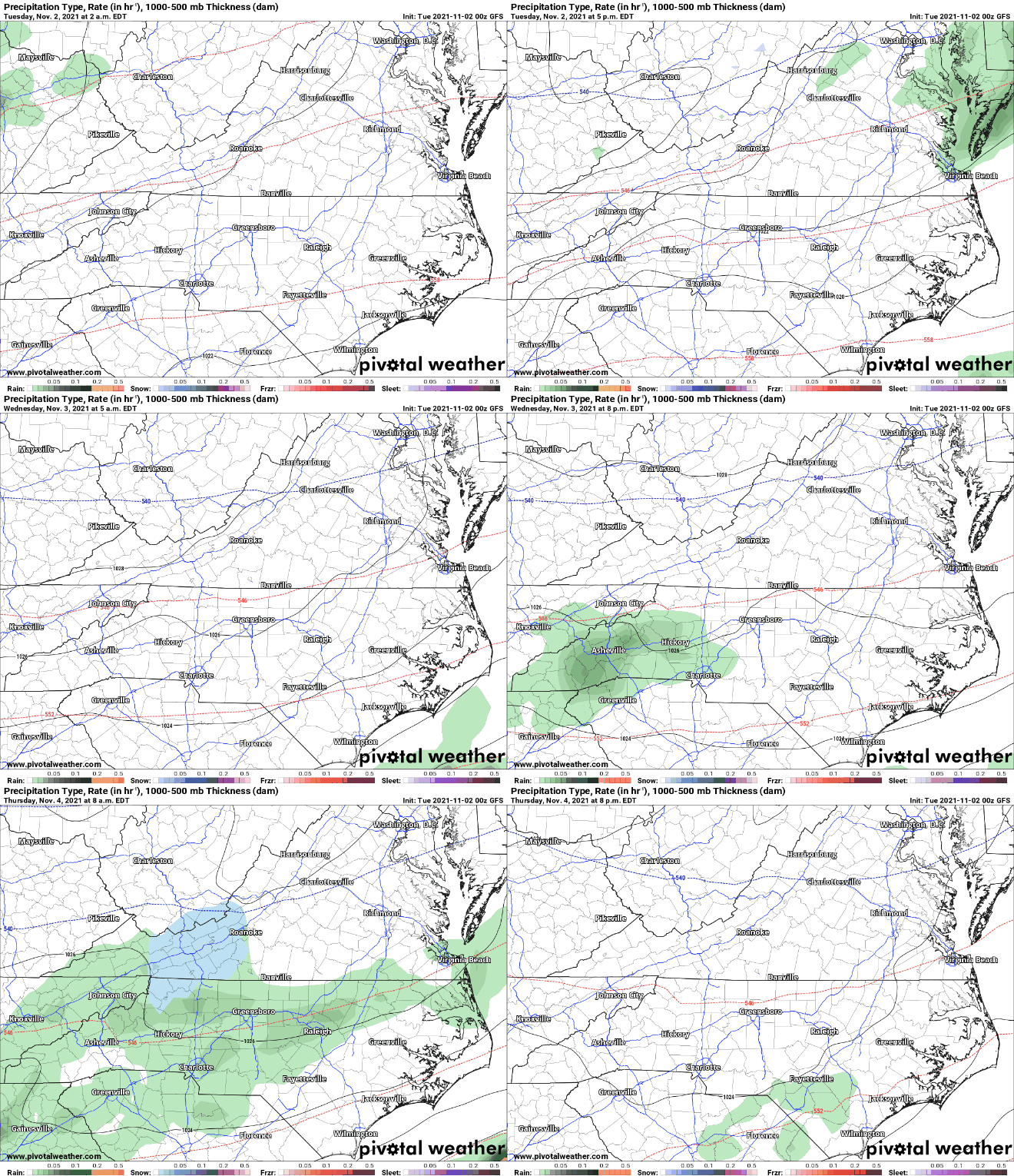
Scattered Snow Showers Possible Around Portions of WNC Thursday AM

Some models have been hinting at the chance for scattered snow showers early Thursday morning. The atmosphere will warm over the day on Thursday, but around day break I believe that some around WNC will be seeing their first snowflakes of the season.

Which Models Show Winter Weather

At this point in time the European model along with the Canadian model and the short range NAM 3km all show some form of scattered snow showers from overrunning precipitation moving in from the South. As the day progresses, the warm nose will erode away any cold layer that was present and we will switch to just rainfall. Comparing those models with the GFS, and one will find that the GFS is the wettest solution, but is also the warmest. One of the main difference I am finding among models that will determine snowfall is the amount of dry air present in the atmosphere. I’ll explain below.

Contact my local trusted roofing source Matt at RedWolf Contracting Services to take care of all of your roof replacements. From shingles, to metal roofing, and even commercial rubber membrane, Matt has the resources and solutions to take care of your job in a professional and cost effective manner. Call (828) 772-9778 or visit nc-roofers.com to set up your free roof inspection.

Dry Air & Snowfall

When dry air is in place in an atmosphere, dynamic cooling can occur. Dynamic cooling is a process where an air parcel cools until the parcel is fully saturated with water. It is a natural phenomenon that occurs in nature. The European model is hinting at significantly drier air compared to what the GFS shows and that is creating some forecast conflict. The question on Thursday morning won’t be a matter of if there is precipitation, snow will fall around WNC if enough dry air is in place a loft. Below check out the most recent European model run compared to the most recent GFS model run.

European Model Courtesy of Pivotalweather.com

GFS Model Courtesy of Pivotalweather.com

Short Range Models

Checking in on the short range models, which are what we begin to focus on as the system approaches.. you’ll see that the NAM3km is also showing some snowfall early Thursday morning. While this doesn’t look to be impactful on roadways, many around the area could see their first snowflakes of the season. Look at the NAM 3km below. It also shows the dry air that causes the snowfall to occur.

NAM 3km Courtesy of Pivotalweather.com

High Elevation Accumulation Likely

No significant accumulation is expected, but the NAM 3km is showing a dusting to 1” being possible above 4500’ around WNC. These totals could go up if more dry air is present, but as of now it looks like the column get saturated and everyone switches to rainfall by 10-11am. Check out the Nam 3km below.

Snowfall Accumulation Courtesy of Pivotalweather.com

Live Update Coming

I’ll be doing a live update here in the next day or so to update you on where models have progressed to and what the most likely scenario will occur. Check back on my Facebook page for that soon!

2021 AshevilleWX Fall Forecast For Peak Color Dates

Each year Evan Fisher and I put together our thoughts as to when leaves will reach peak color at various locations around WNC. Though these dates are not exact. Below are the dates that we now think peak color will arrive in WNC. For many locations in the high country above 5000’ peak color is almost past, but for locations below 3500’ peak color is just around the corner!

Contact my local trusted roofing source Matt at RedWolf Contracting Services to take care of all of your roof replacements. From shingles, to metal roofing, and even commercial rubber membrane, Matt has the resources and solutions to take care of your job in a professional and cost effective manner. Call (828) 772-9778 or visit nc-roofers.com to set up your free roof inspection.

Map Produce by Evan Fisher In Coordination With Meteorologist Hunter Ward

Mild Temps Expected Through The Week With A Cold Front Arriving Next Weekend For WNC

We will finally begin to dry out around WNC following upwards of 4” of rainfall that fell on most locations. Luckily next week appears to be relatively dry around the area. Temperatures though during the week could push into the 80’s on Wednesday and Thursday around WNC so still a little bit of weather to sweat in, but nothing to major.

Contact my local trusted roofing source Matt at RedWolf Contracting Services to take care of all of your roof replacements. From shingles, to metal roofing, and even commercial rubber membrane, Matt has the resources and solutions to take care of your job in a professional and cost effective manner. Call (828) 772-9778 or visit nc-roofers.com to set up your free roof inspection.

Euro Temps Sunday AM Courtesy of Weathermodels.com

Just above I posted the image of the most recent European Model run. It drops many areas around WNC into the low 40’s next Sunday morning. It will certainly feel like fall around WNC as this cold front arrives. Check out the progression of the front below.

Euro 10 Day Courtesy of Weathermodels.com

Dry Period Begins NOW!

The next 10 days look to be somewhat dry around WNC, with only the chance for a few showers along the NC/TN border as we progress. This could all change, but currently it is a great sign that the European model doesn’t show measurable precipitin over the next 10 days. We need to dry out here in WNC! Below you can see the Euro and what it shows regarding precipitation over the next 10 days.

Fall Leaf Color Update

Color is beginning to peak in the highest elevations of WNC, but a soggy and warm week this past week have stalled the color change. Look for that to pick back up here over the next week and then kick into hyperdrive to end October. Winds from the frontal passage late next Saturday night could blow some foliage off of the trees, but it remains to be seen how high those winds actually gusts. Models show gusts between 20-30mph, which could blow some leaves off… but it won’t be devastating to the leaf crop imo. So to recap, next weekend appears to be a nice weekend for leaf peeping and next Sunday will likely turn out to be the choice day during the afternoon hours to ride the Blue Ridge Parkway.

Fall Feel Comes to WNC Thursday Morning, Continues Through Weekend

Pumpkin Spice Alert

Thats right! Fall like weather appears hear to stay for the time being, and the sweat of summer finally appears to be moving farther South. Thus you will begin to see Pumpkin Spice Alerts abound. In jest, I refer to this initial cold spells as Pumpkin Spice Alerts when the temperatures are projected to dip below 50 degrees in the mornings. It appears the first is upon us now, and its going to feel very nice to end next week, and next weekend.

Contact my local trusted roofing source Matt at RedWolf Contracting Services to take care of all of your roof replacements. From shingles, to metal roofing, and even commercial rubber membrane, Matt has the resources and solutions to take care of your job in a professional and cost effective manner. Call (828) 772-9778 or visit nc-roofers.com to set up your free roof inspection.

GFS Projected Thursday Morning Temps Courtesy of Weathermodels.com

Above you can see the most recent run of the GFS model. Notice how it shows a significant cold front moving through the area on Wednesday. This will likely bring heavy rain to many across the area as we progress through the day Wednesday. Below you can see the GFS model projection rainfall totals for Wednesday afternoon.

GFS Rainfall Totals Through Wednesday Evening

Soggy Beginning To Next Week Likely

The GFS model is showing persistent showers each day of next week up until Wednesday night when the frontal passage occurs. Most locations will only see between 1”-2” so flash flooding though it can’t be ruled out, is not very likely to become a problem. I have added the GFS Precipitation Depiction below so you can see how intermediate showers arrive and move through the area quickly to begin the week.

GFS 50-STATES USA North Carolina Precipitation Type.gif

Ida To Bring Heavy Rainfall To Far SW WNC & Also Northern Escarpment, Lighter Totals Closer To Asheville

Rain is back in the forecast for WNC Tuesday into Wednesday as the affects from former Hurricane Ida, which devastated the LA coast, moves through. Isolated locations around WNC will see heavy rainfall as the event progresses. Notice on the map below where I have highlighted the areas of concern for flooding. Notice that most areas who received significant flooding from Fred will be spared by Ida.

NAM 3km Rainfall Totals Courtesy of Weathermodels.com

Contact my local trusted roofing source Matt at RedWolf Contracting Services to take care of all of your roof replacements. From shingles, to metal roofing, and even commercial rubber membrane, Matt has the resources and solutions to take care of your job in a professional and cost effective manner. Call (828) 772-9778 or visit nc-roofers.com to set up your free roof inspection.

When Will Rainfall Begin

Below you can see the most recent run of the Nam 3km which shows the rainfall moving in early Tuesday morning, with several rounds to follow. Rainfall looks to move out of the area by mid day on Wednesday but it appears that gusty winds will stick around.

Nam 3km Courtesy of Weathermodels.com

Gusty Winds Possible

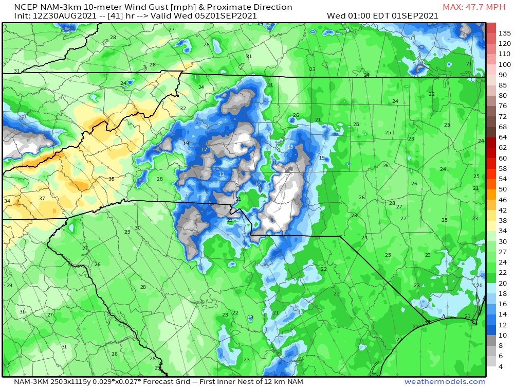
Winds will gust to 35mph Tuesday evening and into Wednesday morning as the Post Tropical Low passes by. Higher elevations will likely see gusts over 50mph, especially when the winds shift to a NW flow on Wednesday afternoon. Below you can see the Nam 3km as the bulk of the wind moves in.

Wind Gusts As Ida Moves Through Courtesy of Weathermodels.com

Wind Gusts As Ida Moves Through Courtesy of Weathermodels.com

Overall Impact Summery

I believe that there will be some flooding around WNC that is directly linked to Ida, however many ditches could overflow around WNC just simply because they have not properly been cleaned out form Fred’s rainfall. As you can see from the models above, rainfall will be limited around the immediate Asheville area, but a heavy downpour can still cause flooding. I had a home that I am remodeling flood near Asheville County Club last week due to a heavy rainfall and storm drains that had yet to be properly cleared. This is my biggest concern around the Buncombe County and Haywood County areas. Transylvania County could see 2”+ of rainfall from this storm and flooding will be possible again. That is the area I am most concerned about. I am also concerned about the Northern Escarpment area that include Blowing Rock & Boone. This area looks to get hammered by heavy rainfall that redevelops as the front comes of the Escarpment. This motion will cause upscoping into the Boone area and significant rainfall will be wrung out of this system. Areas like Lenoir & Boone are going to get hammered with up to 6” of rainfall. Please be mindful of this and be careful traveling around those areas north of I-40 tomorrow and into Wednesday! Turn around, don’t drown!

Flooding Rain Expected Over WNC Through Next 7 Days as Fred Pushes Through

Tropical moisture is on the horizon for WNC as we progress into Hurricane Season. A large push of moisture that will be associated with Tropical Depression Fred as we move into next week could cause flash flooding in many areas. There are varying solutions as to how strong Fred will become in the Gulf, but the heavy rainfall appears imminent. Below you can see the most recent European Model tracks for the 6z Spaghetti Model run.

Fred Projected Tracks From European Model Courtesy of Weathermodels.com

How Much Rainfall is Possible?

There is a wide range of totals showing up on current model projections for WNC. Currently the GFS(seen below) shows only 2”-3” of rainfall for most, whereas the European models shows much higher totals of 4”-6” of rainfall with spots over 8”. These tropical systems can be very hard to model, but one thing is becoming more and more clear and that is the fact that heavy moisture is on the way for early next week.

GFS Rainfall Totals Courtesy of Weathermodels.com

Contact my local trusted roofing source Matt at RedWolf Contracting Services to take care of all of your roof replacements. From shingles, to metal roofing, and even commercial rubber membrane, Matt has the resources and solutions to take care of yo…

Contact my local trusted roofing source Matt at RedWolf Contracting Services to take care of all of your roof replacements. From shingles, to metal roofing, and even commercial rubber membrane, Matt has the resources and solutions to take care of your job in a professional and cost effective manner. Call (828) 772-9778 or visit nc-roofers.com to set up your free roof inspection.

Euro Rainfall Totals Through Next Week Courtesy of Weathermodels.com

How Strong Will Fred Get?

Most models show Fred being a big time rain maker and a limited wind threat. That could change, but check out this chart from Tropicaltidbits.com that shows each models peak intensity. This could change, but I am not expecting a high impact wind event for WNC from this system. The main threat will be flooding.

Intensity forecast courtesy of Tropicaltidbits.com

More Data To Come

Ill have more articles and even a live update if necessary to get you prepared for this rainfall. Timing for the heaviest rainfall appears to be on Tuesday and into Wednesday so it would be wise now to begin to prepare around that time frame. Check back soon for more information!

Tropical Storm Claudette To Bring Excessive Rain To WNC Tonight/Tomorrow AM

An active evening of weather is in store for WNC as Tropical Storm Claudette has its sights set on the area. Models indicated that upwards of 2” of rainfall will be possible for many over the evening hours of tonight and early tomorrow morning. High winds will also be possible as the system pushes through. Below ill detail out the various tracks and which one will bring the most impacts to WNC.

Contact my local trusted roofing source Matt at RedWolf Contracting Services to take care of all of your roof replacements. From shingles, to metal roofing, and even commercial rubber membrane, Matt has the resources and solutions to take care of your job in a professional and cost effective manner. Call (828) 772-9778 or visit nc-roofers.com to set up your free roof inspection.

How Much Rainfall With Claudette Bring?

Below you can see the most recent NAM 3km and from the looks of it, locations along the Blue Ridge Escarpment are set to get hammered with rainfall. Many locations could see over 3” of rainfall, especially in Transylvania and Henderson Counties. Even around Buncombe County I expect to see a widespread 2”+ of rainfall. Flash flooding will be likely late tonight & early tomorrow morning, with ponding on roadways making travel hazardous.

Nam 3km Precipitation Total Courtesy of Weathermodels.com

Storm Track

I have added the NAM 3km progression of the storm so that you can see how the rainfall will approach.

NAM 3km Storm Track Courtesy of Weathermodels.com

Will There Be High Wind Gusts?

A few gusts over 30mph could be possible, but I believe the main story from this system will be the excessive rainfall. For your reference though I have added the animated depiction of wind gusts over the next 60 hours from the Nam 3km. Locations along the Blue Ridge Escarpment will be where the highest winds gusts are felt. Timing for that will be around sunset this evening.

Nam 3km Wind Gusts

Hot On Monday, But Mild Rest of Next Week

The 10 day forecast shows a very hot day on Monday, but then temperatures that do not get out of the 70s for the next week! So its does appear that we will escape the extended sweltering heat for the foreseeable future. Enjoy the cool down!!

Euro Courtesy of Weathermodels.com