Strong Storms Likely This Afternoon Around WNC

Storms will move into WNC later this afternoon and all forms of severe weather will be possible including isolated hail. Scattered showers will begin this morning, and as the afternoon progresses another line will develop and move through the area between 5-8pm. A good bit of lightning will be possible with these storms as well depending on how much daytime heating occurs. As these storms progress into the Piedmont of NC they will enhance and larger hail could be found. So, a day to watch the weather and move indoors when thunder roars! Below check out the most recent model data that shows the systems progression.

The trusted local accounting firm for WNC, let the team of Adrianne, Caroyl, & Naomi take care of all of your tax needs. Whether you need payroll/business accounting help or assistance filing your personal taxes, these ladies are the experts to …

The trusted local accounting firm for WNC, let the team of Adrianne, Caroyl, & Naomi take care of all of your tax needs. Whether you need payroll/business accounting help or assistance filing your personal taxes, these ladies are the experts to put your trust with. Give them a call (828) 684-7374 or visit their website http://www.kruseaccounting.com to set up your appointment today!

HRRR Courtesy of Weathermodels.com

Contact my local trusted roofing source Matt at RedWolf Contracting Services to take care of all of your roof replacements. From shingles, to metal roofing, and even commercial rubber membrane, Matt has the resources and solutions to take care of yo…

Contact my local trusted roofing source Matt at RedWolf Contracting Services to take care of all of your roof replacements. From shingles, to metal roofing, and even commercial rubber membrane, Matt has the resources and solutions to take care of your job in a professional and cost effective manner. Call (828) 772-9778 or visit nc-roofers.com to set up your free roof inspection.

Timing

Scattered showers are likely during the morning hours with some clearing to follow. The sun will destabilized the atmosphere and another round of showers/storms will move through around 4-8pm. Below you get see the projected precipitation data and timing from the HRRR model. Strong winds, lightning, and even hail will be possible around WNC. An isolated tornado threat exists as these storms exit the mountains, and a higher risk for a tornado will exist in the Piedmont of WNC later tonight.

HRRR Courtesy of Weathermodels.com

We're here to help reduce the use of single-use plastics by offering bulk refills of household needs. Come refill your empty containers (shampoo bottles, hand soap dispensers, laundry detergent containers, jars etc) with our more natural products an…

We're here to help reduce the use of single-use plastics by offering bulk refills of household needs. Come refill your empty containers (shampoo bottles, hand soap dispensers, laundry detergent containers, jars etc) with our more natural products and pay by the ounce! To The Brim Click Here

Beautiful Week In Store Next Week

Euro Courtesy of Weathermodels.com

Above you can see the European models 10 day forecast and notice how it doesn’t have Asheville dropping below freezing. There is still a chance for a freeze near the end of the month, but planting a few chance seeds may not be a bad idea in your garden if you don’t mind losing a few to a possible late frost. All and all the next 10 days will shape up to be rather nice with limited chances at rainfall and only scattered showers on the days where it rains. Enjoy it! I am sure we will turn rainy again soon lol.

Severe Weather Moves Back Into Forecast For WNC Sunday Afternoon

Another frontal passage will occur during the afternoon on Sunday, and with it could be a strong line of storms. Below you can see the most recent NAM 3km depiction of the system as it pushes through later in the afternoon on Sunday. High winds, lightning, and even isolated hail are possible with this system as well as flash flooding across the area. Watch below at the end of the run and you can see the line of storms enter WNC.

The trusted local accounting firm for WNC, let the team of Adrianne, Caroyl, & Naomi take care of all of your tax needs. Whether you need payroll/business accounting help or assistance filing your personal taxes, these ladies are the experts to …

The trusted local accounting firm for WNC, let the team of Adrianne, Caroyl, & Naomi take care of all of your tax needs. Whether you need payroll/business accounting help or assistance filing your personal taxes, these ladies are the experts to put your trust with. Give them a call (828) 684-7374 or visit their website http://www.kruseaccounting.com to set up your appointment today!

Simulated Radar Courtesy of Weathermodels.com

High Winds Likely Sunday

Winds will blow out of the South on Sunday before the frontal passage, and gusts will reach over 40 mph in some locations. Below you can see the NAM 3km in the early afternoon. Notice how most stations in WNC are showing +40mph peak gusts during those times. Also notice how the wind barbs are positioned out of the South.

Wind Gust Map Courtesy of Weathermodels.com

Contact my local trusted roofing source Matt at RedWolf Contracting Services to take care of all of your roof replacements. From shingles, to metal roofing, and even commercial rubber membrane, Matt has the resources and solutions to take care of yo…

Contact my local trusted roofing source Matt at RedWolf Contracting Services to take care of all of your roof replacements. From shingles, to metal roofing, and even commercial rubber membrane, Matt has the resources and solutions to take care of your job in a professional and cost effective manner. Call (828) 772-9778 or visit nc-roofers.com to set up your free roof inspection.

Another Freeze Likely To End Next Week

Do not plant your tender veggies just yet in WNC, another frost is likely on the way to end the week next week. Models indicate that temperatures in the upper 20’s will be possible both Thursday and Friday of next week. Prepare to bring in or cover sensitive vegetation that you have planted ahead of this frost to protect your plant investment. Below you can see the GFS projected temperatures for early Friday morning in WNC. BRRRRR… hopefully this will be our last frost but they are possible through early to mid May.

FrostApril220201GFS.png
We're here to help reduce the use of single-use plastics by offering bulk refills of household needs. Come refill your empty containers (shampoo bottles, hand soap dispensers, laundry detergent containers, jars etc) with our more natural products an…

We're here to help reduce the use of single-use plastics by offering bulk refills of household needs. Come refill your empty containers (shampoo bottles, hand soap dispensers, laundry detergent containers, jars etc) with our more natural products and pay by the ounce! To The Brim Click Here

Chance For Snow Showers Around WNC Late Next Week

Models are indicating that there is a chance for some snow showers late next week around WNC as a cold front moves through. There is still great uncertainty, but it does appear as though at least for the higher elevations that wintry weather is not done for the season. Heavy snow will be possible above 3500’ with this system and even several inches of snow could accumulate in isolated areas. I’ll have more info on this later next week, but here is what the GFS shows for Thursday morning of next week.

images courtesy of www.weathermodels.com

images courtesy of www.weathermodels.com

Strong Line Of Storm To Move Through WNC Thursday Morning

NC_swody2.png

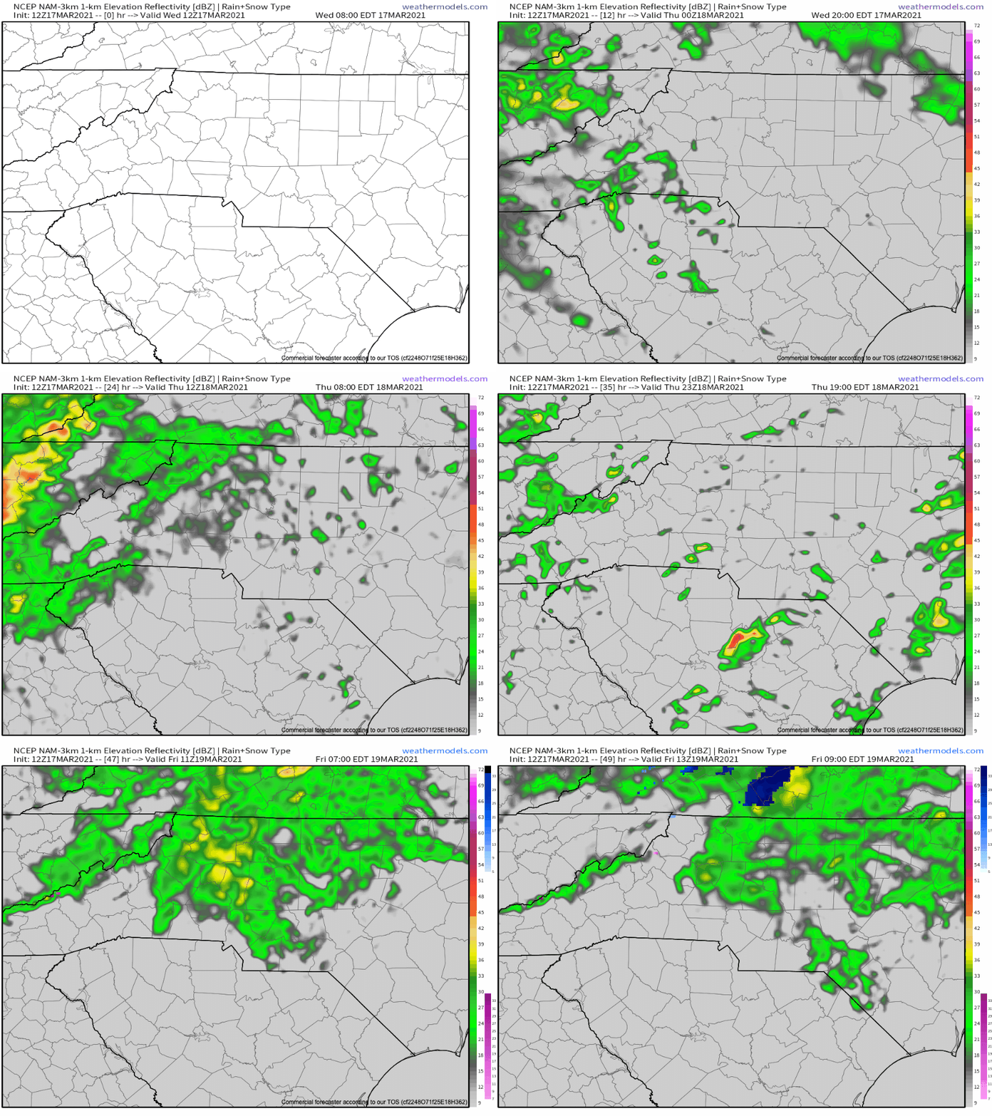
A stout line of storms will move through the mountains of WNC Thursday morning around 8-11am. This will bring with it the chance for damaging wind gusts, and isolated hail throughout the area. While many others around the Southeast will experience a heightened tornado threat, timing and terrain here in the mountains of WNC will limit the immediate threat for tornados in our area. Though a spin-up cannot be ruled out from this system, they are unlikely. Below you can see the progression from the most recent NAM 3km.

Contact my local trusted roofing source Matt at RedWolf Contracting Services to take care of all of your roof replacements. From shingles, to metal roofing, and even commercial rubber membrane, Matt has the resources and solutions to take care of yo…

Contact my local trusted roofing source Matt at RedWolf Contracting Services to take care of all of your roof replacements. From shingles, to metal roofing, and even commercial rubber membrane, Matt has the resources and solutions to take care of your job in a professional and cost effective manner. Call (828) 772-9778 or visit nc-roofers.com to set up your free roof inspection.

NAM-CONUS 3-km Metro Regions Charlotte Simulated Radar (1).gif
We're here to help reduce the use of single-use plastics by offering bulk refills of household needs. Come refill your empty containers (shampoo bottles, hand soap dispensers, laundry detergent containers, jars etc) with our more natural products an…

We're here to help reduce the use of single-use plastics by offering bulk refills of household needs. Come refill your empty containers (shampoo bottles, hand soap dispensers, laundry detergent containers, jars etc) with our more natural products and pay by the ounce! To The Brim Click Here

Timing For WNC?

Looking below at the most recent overview chart from the HRRR model run and you can see that scattered storms are expected to move in late this evening, but the main line of storms will move through between 8am-11am tomorrow for WNC. Storm development during this time frame will be less explosive compared to if this line was moving through during the afternoon hours, so that will likely keep some of damaging wind threat at bay.

HRRR Courtesy of Weathermodels.com

The trusted local accounting firm for WNC, let the team of Adrianne, Caroyl, & Naomi take care of all of your tax needs. Whether you need payroll/business accounting help or assistance filing your personal taxes, these ladies are the experts to …

The trusted local accounting firm for WNC, let the team of Adrianne, Caroyl, & Naomi take care of all of your tax needs. Whether you need payroll/business accounting help or assistance filing your personal taxes, these ladies are the experts to put your trust with. Give them a call (828) 684-7374 or visit their website http://www.kruseaccounting.com to set up your appointment today!

Increased Threat For Tornados Across South Today & Tomorrow

As you can see on the first image in this article, there is a severe weather threat for the majority of NC, SC, & GA tomorrow… but today a high risk for tornados and severe weather exists across Mississippi. This threat will also extend to Alabama, Arkansas, & Tennessee, as well as Louisiana. It could be a day that goes down in history. Check out the SPC forecast for today below. Please keep these people in your thoughts and prayers.

MS_swody1.png

Live Update Tonight at 5pm

Join me live on Facebook tonight as I discuss the severe weather that is impending for WNC. I will also cover the ongoing tornado threat across the Southeast! See you then!

Snow Showers & Freezing Rain Possible Along Blue Ridge Escarpment Early Monday AM

A chance for a few scattered snow showers and isolated freezing rain will be possible early tomorrow morning along the Blue Ridge Escarpment. Though not significant, the timing of this icy weather could make for isolated slick conditions early tomorrow morning before the precipitation switches to rainfall. Below you can see the most recent Nam 3km progression of the moisture.

We're here to help reduce the use of single-use plastics by offering bulk refills of household needs. Come refill your empty containers (shampoo bottles, hand soap dispensers, laundry detergent containers, jars etc) with our more natural products an…

We're here to help reduce the use of single-use plastics by offering bulk refills of household needs. Come refill your empty containers (shampoo bottles, hand soap dispensers, laundry detergent containers, jars etc) with our more natural products and pay by the ounce! To The Brim Click Here

NAM 3km Precies Projection Courtesy of Weathermodels.com

The trusted local accounting firm for WNC, let the team of Adrianne, Caroyl, & Naomi take care of all of your tax needs. Whether you need payroll/business accounting help or assistance filing your personal taxes, these ladies are the experts to …

The trusted local accounting firm for WNC, let the team of Adrianne, Caroyl, & Naomi take care of all of your tax needs. Whether you need payroll/business accounting help or assistance filing your personal taxes, these ladies are the experts to put your trust with. Give them a call (828) 684-7374 or visit their website http://www.kruseaccounting.com to set up your appointment today!

NAM Projected Freezing Rain Totals

The Nam is projecting a light freezing rain event for Transylvania, Henderson, Polk, Eastern Buncombe, Mcdowell, Mitchell, Avery, & Watagua counties. This light precipitation will be different compared to this past week. As the light precipitation falls, temperatures right at freezing will aid ice accretion in certain areas along the Blue Ridge Escarpment. On this past Thursday heavy precipitation kept ice from accumulating, but with the light precipitation expected tomorrow morning… we will be dealing with an entirely different situation. Light precipitation can accrual on surfaces much easier compared to when the precip is heavy and dripping. The consistent mist right at 32 degrees is much more dangerous compared to a downpour of rain at 32 degrees. We will be dealing with the more dangerous type here. Below you can see the NAM projected ice accumulation totals. It only takes a couple of hundredths of an inch to make conditions very dangerous.

Come to where Mother Nature waved her magic wand and created one of the most natural of all wonders, Natural Hot Mineral Waters. Heated deep within the earth, these crystal clear carbonated waters are are world famous for their mineral content and l…

Come to where Mother Nature waved her magic wand and created one of the most natural of all wonders, Natural Hot Mineral Waters. Heated deep within the earth, these crystal clear carbonated waters are are world famous for their mineral content and legendary healing powers. We pipe these waters to modern outdoor jetted hot tubs that we rent privately by the hour. In addition to our World Famous Natural Hot Mineral baths the day spa offers massage, body treatments, and skin care options. Hot Springs Resort also offers accommodations and camping options. Please visit http://www.nchotsprings.com for more information.

NAM Ice Accumulation Courtesy of Pivotalweather.com

Take It Slow Monday AM, Temps Will Warm

If you are worried about road conditions, wait until around noon when things will warm up around WNC and precipitation will transition to rainfall. Around the immediate Asheville area conditions could be a bit icy, but locations like Brevard & Hendersonville will stand a better chance of seeing slick roadways.

Isolated Snow Could Mix In

Looking at soundings for tomorrow morning across the area, and what sticks out to me is only a very small warm nose. That means that precipitation could very well begin as sleet or snowfall for your location. By 6am I expect most to have switched to a freezing drizzle or just rainfall, but some isolated minor snowfall accumulation of a a dusting-1” could be possible, especially along the Blue Ridge Escarpment. Also, the Balsams appear to have a chance to see snowfall as well from this system as they are situated above that initial push of warm air. Check out the NAM 3km snowfall map below.

NAM 3km Snowfall Map Courtesy of Weathermodels.com

Call the team that keeps my truck clean at A&R Specialist! David, Matt & Harley run A&R Specialist at 621 Brevard Rd. and they are the guys to trust with your vehicle cleaning & detailing. Whether you need a deep wax every once in a …

Call the team that keeps my truck clean at A&R Specialist! David, Matt & Harley run A&R Specialist at 621 Brevard Rd. and they are the guys to trust with your vehicle cleaning & detailing. Whether you need a deep wax every once in a while or a quality clean and detail, you can feel safe putting your car in the hands of A&R Specialist! Call (828) 708-3718 to set up your appointment today. https://www.facebook.com/ARSpecialistsLLC

Chances Increasing For Snowfall Next Weekend For WNC

I have my eye on a low pressure that will move through WNC next weekend with cold air in place. This has been something that has been lacking the past month on the models, but now we are beginning to see high pressure show up to our NE. This strong high could provide the cold air we have been missing when moisture makes it our way here in WNC. So, note that I have my eye on the possibility for some form of wintry weather again next weekend. Nothing is certain yet, in fact there might not even be a storm.. but the signal is there and models seem to be moving towards a more cold solution. I will keep you updated on this as we progress through next week.

Contact my local trusted roofing source Matt at RedWolf Contracting Services to take care of all of your roof replacements. From shingles, to metal roofing, and even commercial rubber membrane, Matt has the resources and solutions to take care of yo…

Contact my local trusted roofing source Matt at RedWolf Contracting Services to take care of all of your roof replacements. From shingles, to metal roofing, and even commercial rubber membrane, Matt has the resources and solutions to take care of your job in a professional and cost effective manner. Call (828) 772-9778 or visit nc-roofers.com to set up your free roof inspection.

Icing To Affect Portions Of WNC Early Thursday Morning, Slick Roadways Possible

Icy Threat Increasing For WNC

Cold air appears to be more abundant tomorrow morning than originally thought as precipitation, and that could make for a very icy morning commute around WNC. Freezing rain and sleet will be likely for many mountain counties early tomorrow morning as a cold wedge sets in at the surface and ice accretion occurs. Below you can see a model depiction from the most recent Nam3km during the hight of the icing. This is at 5am Thursday am.

Nam 3km 5am Thursday Courtesy of Weathermodels.com

Contact my local trusted roofing source Matt at RedWolf Contracting Services to take care of all of your roof replacements. From shingles, to metal roofing, and even commercial rubber membrane, Matt has the resources and solutions to take care of yo…

Contact my local trusted roofing source Matt at RedWolf Contracting Services to take care of all of your roof replacements. From shingles, to metal roofing, and even commercial rubber membrane, Matt has the resources and solutions to take care of your job in a professional and cost effective manner. Call (828) 772-9778 or visit nc-roofers.com to set up your free roof inspection.

Timing

The Nam 3km has precipitation moving in around 1 am early Thursday morning as temperatures are in the low 30’s and even upper 20’s around WNC. Depending on how close you are to the high pressure to our Northeast, will determine if you see freezing rain at your location and just how much.

NAM 3km P-type Courtesy of Weathermodels.com

NAM 3km P-type Courtesy of Weathermodels.com

We're here to help reduce the use of single-use plastics by offering bulk refills of household needs. Come refill your empty containers (shampoo bottles, hand soap dispensers, laundry detergent containers, jars etc) with our more natural products an…

We're here to help reduce the use of single-use plastics by offering bulk refills of household needs. Come refill your empty containers (shampoo bottles, hand soap dispensers, laundry detergent containers, jars etc) with our more natural products and pay by the ounce! To The Brim Click Here

Highest Impacts

Impacts from this storm could be minimal around the immediate Asheville area, but as your progress toward locations like Hendersonville & Black Mountain the chance for impactful icing increases significantly. Only 1-2 degrees in temperature difference will change the entire landscape. I won’t be surprised to see nasty roads around Henderson Co, tomorrow morning with only slight icing in the trees around Asheville. That being said, some models do show the Asheville area getting a bit colder then other models, so 1-2 degrees will make a big difference. As you work your way north and west into Madison & Haywood Counties the effects from ice will fall off.

fram_acc.us_ma.png
The trusted local accounting firm for WNC, let the team of Adrianne, Caroyl, & Naomi take care of all of your tax needs. Whether you need payroll/business accounting help or assistance filing your personal taxes, these ladies are the experts to …

The trusted local accounting firm for WNC, let the team of Adrianne, Caroyl, & Naomi take care of all of your tax needs. Whether you need payroll/business accounting help or assistance filing your personal taxes, these ladies are the experts to put your trust with. Give them a call (828) 684-7374 or visit their website http://www.kruseaccounting.com to set up your appointment today!

Other Model Data

The short range Canadian model also shows a slight icing event even for the Asheville area. Conditions will go downhill as you progress down I-26 towards Polk co. so please be mindful of this if you have to travel that way tomorrow morning. Below you can see The short range Canadian model.

Come to where Mother Nature waved her magic wand and created one of the most natural of all wonders, Natural Hot Mineral Waters. Heated deep within the earth, these crystal clear carbonated waters are are world famous for their mineral content and l…

Come to where Mother Nature waved her magic wand and created one of the most natural of all wonders, Natural Hot Mineral Waters. Heated deep within the earth, these crystal clear carbonated waters are are world famous for their mineral content and legendary healing powers. We pipe these waters to modern outdoor jetted hot tubs that we rent privately by the hour. In addition to our World Famous Natural Hot Mineral baths the day spa offers massage, body treatments, and skin care options. Hot Springs Resort also offers accommodations and camping options. Please visit http://www.nchotsprings.com for more information.

fram_acc.us_ma.png

Column of Air

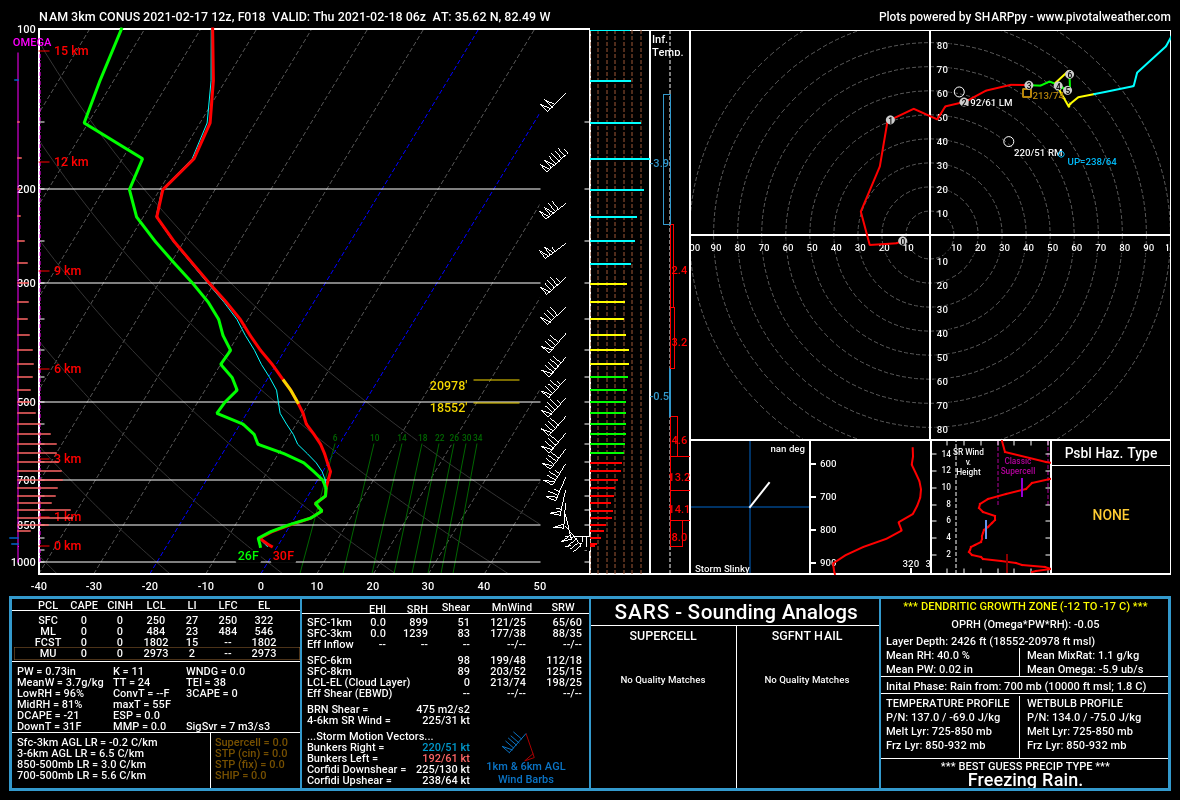
As you move from the Asheville area to the Hendersonville area, surface temperatures early Thursday morning will decrease. Below you can see a sounding from the Asheville area early tomorrow morning. Notice how surface temperatures are right at 30 degrees. Prime temperature for icing.

Asheville Sounding As Precipitation Moves In Courtesy of Pivotalweather.com

Asheville Sounding As Precipitation Moves In Courtesy of Pivotalweather.com

Call the team that keeps my truck clean at A&R Specialist! David, Matt & Harley run A&R Specialist at 621 Brevard Rd. and they are the guys to trust with your vehicle cleaning & detailing. Whether you need a deep wax every once in a …

Call the team that keeps my truck clean at A&R Specialist! David, Matt & Harley run A&R Specialist at 621 Brevard Rd. and they are the guys to trust with your vehicle cleaning & detailing. Whether you need a deep wax every once in a while or a quality clean and detail, you can feel safe putting your car in the hands of A&R Specialist! Call (828) 708-3718 to set up your appointment today. https://www.facebook.com/ARSpecialistsLLC

Power Outages Possible Across NC Thursday

Power outages will certainly be possible around WNC especially along the Blue Ridge Escarpment. As you work into the Piedmont of WNC those power outages will only increase. This will be a significant ice storm for the Piedmont of NC. Trees will likely topple under the weight of ice tomorrow morning and power will likely go out for many. Even here in WNC it will be wise to prepare to have some form of alternative heat. Depending on your location, there is a chance your power could go out due to falling trees as well. Please take this afternoon to make those preparations.

Icing Likely For Portions of WNC Thursday AM

After several rounds of rainfall have moved through WNC without causing any problems, it appears high pressure will finally move into place on Thursday morning and icing could occur. As the high pressure to our North moves over the Northeast, cold air will funnel into areas where cold air is known to dam up. This is called cold air damming. CAD or cold air damming can create for icy conditions all across the Mountains of WNC depending on how strong the cold air source is. Looking at short range models, this cold air source seems to be significant and could cause problems around WNC on your Thursday commute.

Call the team that keeps my truck clean at A&R Specialist! David, Matt & Harley run A&R Specialist at 621 Brevard Rd. and they are the guys to trust with your vehicle cleaning & detailing. Whether you need a deep wax every once in a …

Call the team that keeps my truck clean at A&R Specialist! David, Matt & Harley run A&R Specialist at 621 Brevard Rd. and they are the guys to trust with your vehicle cleaning & detailing. Whether you need a deep wax every once in a while or a quality clean and detail, you can feel safe putting your car in the hands of A&R Specialist! Call (828) 708-3718 to set up your appointment today. https://www.facebook.com/ARSpecialistsLLC

Model Spread

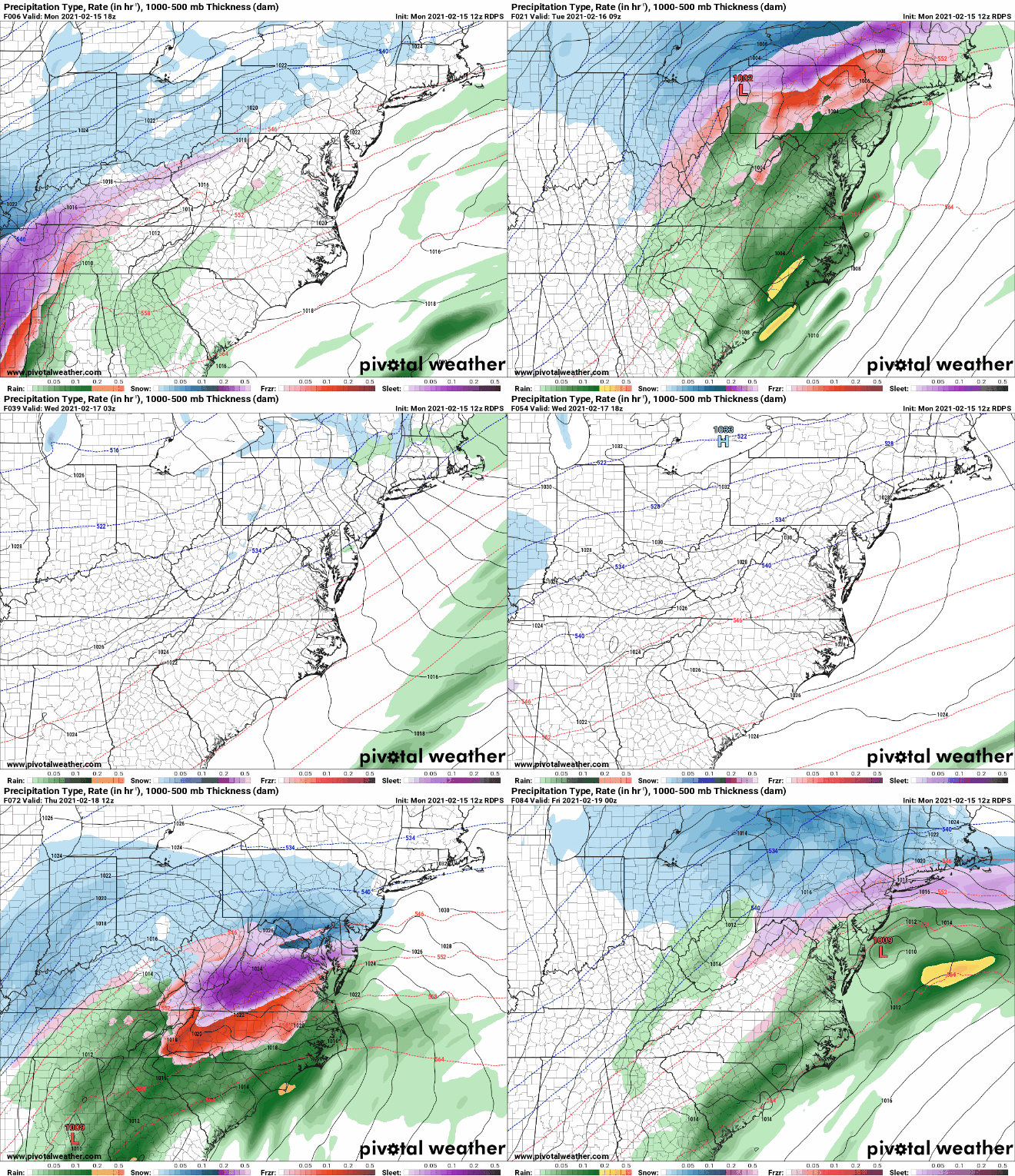
Below you can see the most recent Canadian short range model. This is the most aggressive of the short range models, but does show the possibilities that we could be dealing with. Temperatures will likely fall into the upper 20’s early Thursday morning right before precipitation moves in. Icing will be possible in locations that struggle to push above freezing. Locations in SW WNC like Franklin & Murphy will warm up much quicker compared to Hendersonville & Brevard where icing could last into the mid morning hours. I have also put the map in motion for your pleasure below.

Short Range Canadian Model Courtesy of Pivotalweather.com

Short Range Canadian Model Courtesy of Pivotalweather.com

Contact my local trusted roofing source Matt at RedWolf Contracting Services to take care of all of your roof replacements. From shingles, to metal roofing, and even commercial rubber membrane, Matt has the resources and solutions to take care of yo…

Contact my local trusted roofing source Matt at RedWolf Contracting Services to take care of all of your roof replacements. From shingles, to metal roofing, and even commercial rubber membrane, Matt has the resources and solutions to take care of your job in a professional and cost effective manner. Call (828) 772-9778 or visit nc-roofers.com to set up your free roof inspection.

Short Range Canadian Courtesy of Pivotalweather.com

Short Range Canadian Courtesy of Pivotalweather.com

We're here to help reduce the use of single-use plastics by offering bulk refills of household needs. Come refill your empty containers (shampoo bottles, hand soap dispensers, laundry detergent containers, jars etc) with our more natural products an…

We're here to help reduce the use of single-use plastics by offering bulk refills of household needs. Come refill your empty containers (shampoo bottles, hand soap dispensers, laundry detergent containers, jars etc) with our more natural products and pay by the ounce! To The Brim Click Here

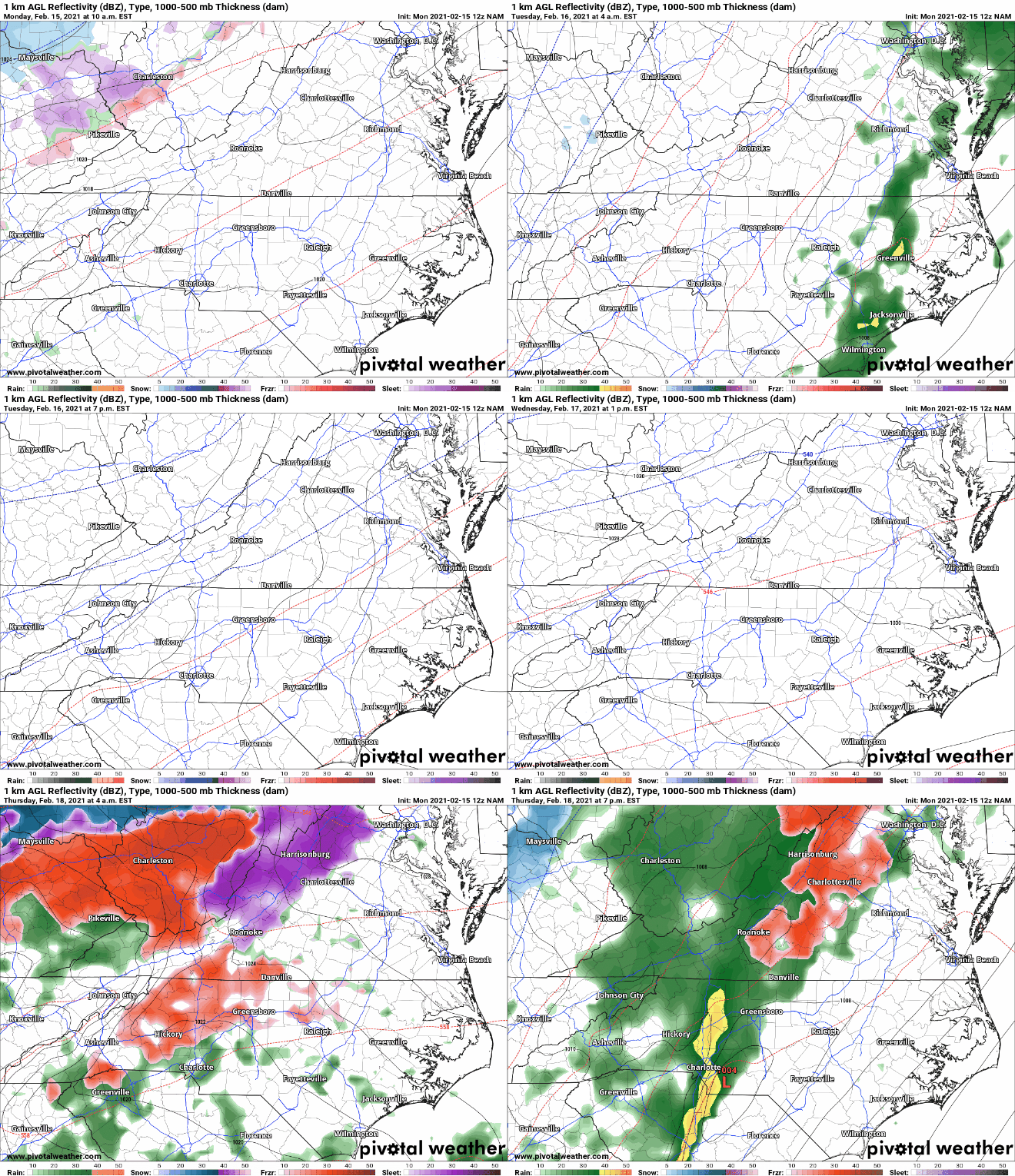
Now let’s take a look at the most recent NAM model and what it depicts. Keep in mind that both of these models are showing some form of icing for a portion of WNC. 1-2 degrees of temperature disparity could cause wildly different results across portions of the area. Locations just a couple of miles down the road from your home can be colder, and their conditions could be must different. Keep this in mind when you are traveling around the area on Thursday. Just because you do not have ice at your house, doesn’t mean that locations to your south, east, or north might not.

The trusted local accounting firm for WNC, let the team of Adrianne, Caroyl, & Naomi take care of all of your tax needs. Whether you need payroll/business accounting help or assistance filing your personal taxes, these ladies are the experts to …

The trusted local accounting firm for WNC, let the team of Adrianne, Caroyl, & Naomi take care of all of your tax needs. Whether you need payroll/business accounting help or assistance filing your personal taxes, these ladies are the experts to put your trust with. Give them a call (828) 684-7374 or visit their website http://www.kruseaccounting.com to set up your appointment today!

NAM Courtesy of Pivotalweather.com

NAM Courtesy of Pivotalweather.com

Come to where Mother Nature waved her magic wand and created one of the most natural of all wonders, Natural Hot Mineral Waters. Heated deep within the earth, these crystal clear carbonated waters are are world famous for their mineral content and l…

Come to where Mother Nature waved her magic wand and created one of the most natural of all wonders, Natural Hot Mineral Waters. Heated deep within the earth, these crystal clear carbonated waters are are world famous for their mineral content and legendary healing powers. We pipe these waters to modern outdoor jetted hot tubs that we rent privately by the hour. In addition to our World Famous Natural Hot Mineral baths the day spa offers massage, body treatments, and skin care options. Hot Springs Resort also offers accommodations and camping options. Please visit http://www.nchotsprings.com for more information.

Projected Ice Totals

Below you can see the ice projection from the most recent NAM model run. These totals should be taken with a grain of salt, but the possibility is there for a medium impact icing event for locations along the Blue Ridge Escarpment. That would include locations like Highlands, Lake Toxaway, Brevard, Hendersonville, Flat Rock, Chimney Rock, Bat Cave, Black Mountain, Spruce Pine, Boone and surrounding areas.

NAM Courtesy of Pivotalweather.com

NAM Courtesy of Pivotalweather.com

NAM ice totals courtesy of Pivotalweather.com

NAM ice totals courtesy of Pivotalweather.com

Lots Of Detail Remain To Be Hammered Out

I am continuing to watch this progression of moisture and evolution of high pressure as we work towards Thursday. I will have another article detailing out the possibility for ice on Thursday later this week when I have more information on what exactly will unfold. Check back soon!

Heavy Snow Likely For WNC Saturday & Into Sunday, Dangerous Travel Possible

A high end overrunning precipitation event appears to be imminent for WNC as moisture streams in from the SW and totals around the area pile up. This will be my last forecast for this event. I will be heading out of time for some planned R&R and will not be furthering my forecast. This is my best guess on what will occur, but it may not pan out exactly how I have projected. Higher totals could be possible. Below you can see my forecast map that Evan Fisher has made for this event!

Come to where Mother Nature waved her magic wand and created one of the most natural of all wonders, Natural Hot Mineral Waters. Heated deep within the earth, these crystal clear carbonated waters are are world famous for their mineral content and l…

Come to where Mother Nature waved her magic wand and created one of the most natural of all wonders, Natural Hot Mineral Waters. Heated deep within the earth, these crystal clear carbonated waters are are world famous for their mineral content and legendary healing powers. We pipe these waters to modern outdoor jetted hot tubs that we rent privately by the hour. In addition to our World Famous Natural Hot Mineral baths the day spa offers massage, body treatments, and skin care options. Hot Springs Resort also offers accommodations and camping options. Please visit http://www.nchotsprings.com for more information.

Call the team that keeps my truck clean at A&R Specialist! David, Matt & Harley run A&R Specialist at 621 Brevard Rd. and they are the guys to trust with your vehicle cleaning & detailing. Whether you need a deep wax every once in a …

Call the team that keeps my truck clean at A&R Specialist! David, Matt & Harley run A&R Specialist at 621 Brevard Rd. and they are the guys to trust with your vehicle cleaning & detailing. Whether you need a deep wax every once in a while or a quality clean and detail, you can feel safe putting your car in the hands of A&R Specialist! Call (828) 708-3718 to set up your appointment today. https://www.facebook.com/ARSpecialistsLLC

Model Data

The most recent NAM & NAM 3km have been showing a significant snowfall for the past several run. With this consistency this storm needs to be taken seriously. High end snow totals of over 6”+ will be possible even around Buncombe Co. & Henderson Co. Take a look at the progression of precipitation below on the most recent NAM 3km.

Contact my local trusted roofing source Matt at RedWolf Contracting Services to take care of all of your roof replacements. From shingles, to metal roofing, and even commercial rubber membrane, Matt has the resources and solutions to take care of yo…

Contact my local trusted roofing source Matt at RedWolf Contracting Services to take care of all of your roof replacements. From shingles, to metal roofing, and even commercial rubber membrane, Matt has the resources and solutions to take care of your job in a professional and cost effective manner. Call (828) 772-9778 or visit nc-roofers.com to set up your free roof inspection.

NAM 3km Courtesy of Weathermodels.com

We're here to help reduce the use of single-use plastics by offering bulk refills of household needs. Come refill your empty containers (shampoo bottles, hand soap dispensers, laundry detergent containers, jars etc) with our more natural products an…

We're here to help reduce the use of single-use plastics by offering bulk refills of household needs. Come refill your empty containers (shampoo bottles, hand soap dispensers, laundry detergent containers, jars etc) with our more natural products and pay by the ounce! To The Brim Click Here

NAM 3km Snowfall Map

The NAM 3km is showing higher total than what I am projecting, and my totals could be a bit low. With that being said, I will not be updated my map. So know that higher totals could be expected, especially in Brevard & Hendersonville.

NAM 3km Snowfall Map Courtesy of Weathermodels.com

The trusted local accounting firm for WNC, let the team of Adrianne, Caroyl, & Naomi take care of all of your tax needs. Whether you need payroll/business accounting help or assistance filing your personal taxes, these ladies are the experts to …

The trusted local accounting firm for WNC, let the team of Adrianne, Caroyl, & Naomi take care of all of your tax needs. Whether you need payroll/business accounting help or assistance filing your personal taxes, these ladies are the experts to put your trust with. Give them a call (828) 684-7374 or visit their website http://www.kruseaccounting.com to set up your appointment today!

Timing

Moisture will begin to stream into the area around 11am tomorrow and that precipitation could begin as rain. As precipitation gets heavier as the afternoon progresses, most locations will switch to snow by 4-5pm. This snowfall will fall through around 2-3am and will accumulate easily after the sun sets. Several inches of heavy wet snow could be possible for your location and power outages could also occur. Today is the day to prepare for this storm! Ensure you have alternative source of heat, water to flush your commodes, and extra food incase you get snowed in!

AshevilleWX Will Be Out Of Town For This Event

I am heading out today for some rest and relaxation. I does appear as though I will get hammered with snow where I am heading, but I won’t be in WNC or providing updates for the storm past this article. I hope that you can respect my time since this just a hobby for me. Please make sure and post your totals in the AshevilleWX Weather Community on Facebook. Enjoy the snow and stay safe!!

Accumulating Snowfall Likely For All of WNC Saturday Afternoon & Into Sunday

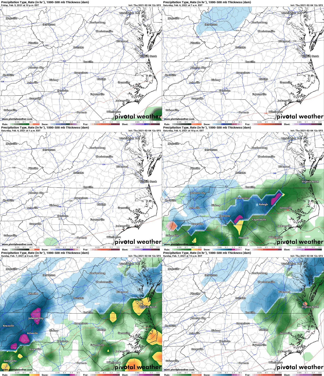
An overrunning precipitation event will likely occur this weekend around WNC where cold temperatures will be in place. Moisture will begin to stream into WNC Saturday afternoon for the SW and will run into a frozen column of air. Snowfall will begin for many as the afternoon progresses and more moisture begins to move in. Models are really just now getting a grip on this solution, so some caution is to be had here but I will do my best to walk you through the possible scenarios.

The trusted local accounting firm for WNC, let the team of Adrianne, Caroyl, & Naomi take care of all of your tax needs. Whether you need payroll/business accounting help or assistance filing your personal taxes, these ladies are the experts to …

The trusted local accounting firm for WNC, let the team of Adrianne, Caroyl, & Naomi take care of all of your tax needs. Whether you need payroll/business accounting help or assistance filing your personal taxes, these ladies are the experts to put your trust with. Give them a call (828) 684-7374 or visit their website http://www.kruseaccounting.com to set up your appointment today!

Model Data

The most recent NAM suite of models has snow beginning late in the afternoon on Saturday, and has several inches on the ground by the time midnight rolls around. Check out the most recent depiction below!

NAM Courtesy of Weathermodels.com

Come to where Mother Nature waved her magic wand and created one of the most natural of all wonders, Natural Hot Mineral Waters. Heated deep within the earth, these crystal clear carbonated waters are are world famous for their mineral content and l…

Come to where Mother Nature waved her magic wand and created one of the most natural of all wonders, Natural Hot Mineral Waters. Heated deep within the earth, these crystal clear carbonated waters are are world famous for their mineral content and legendary healing powers. We pipe these waters to modern outdoor jetted hot tubs that we rent privately by the hour. In addition to our World Famous Natural Hot Mineral baths the day spa offers massage, body treatments, and skin care options. Hot Springs Resort also offers accommodations and camping options. Please visit http://www.nchotsprings.com for more information.

GFS Model Data

The GFS model is showing a similar solution to the NAM with overrunning precipitation becoming predominate later in the afternoon on Saturday.

floop-gfs-2021020412.prateptype_cat.us_state_nc_va.gif
Call the team that keeps my truck clean at A&R Specialist! David, Matt & Harley run A&R Specialist at 621 Brevard Rd. and they are the guys to trust with your vehicle cleaning & detailing. Whether you need a deep wax every once in a …

Call the team that keeps my truck clean at A&R Specialist! David, Matt & Harley run A&R Specialist at 621 Brevard Rd. and they are the guys to trust with your vehicle cleaning & detailing. Whether you need a deep wax every once in a while or a quality clean and detail, you can feel safe putting your car in the hands of A&R Specialist! Call (828) 708-3718 to set up your appointment today. https://www.facebook.com/ARSpecialistsLLC

GFS Snowfall Map

The GFS shows similar accumulation totals for WNC from this snowstorm, and the threat should really start to be taken seriously. 3”-6” of snowfall will cause problems on roadways Saturday evening. Please begin to make preparations.

GFS Snowfall Map Courtesy of Pivotalweather.com

GFS Snowfall Map Courtesy of Pivotalweather.com

GFS Sounding

The column of air that the GFS is showing i’m place over WNC Saturday afternoon is very cold and frozen throughout. This is very supportive of heavy wet snowfall. I believe that wet snow will be the precipitation type with this system as the evening progresses, and several inches of snowfall will be possible!

Contact my local trusted roofing source Matt at RedWolf Contracting Services to take care of all of your roof replacements. From shingles, to metal roofing, and even commercial rubber membrane, Matt has the resources and solutions to take care of yo…

Contact my local trusted roofing source Matt at RedWolf Contracting Services to take care of all of your roof replacements. From shingles, to metal roofing, and even commercial rubber membrane, Matt has the resources and solutions to take care of your job in a professional and cost effective manner. Call (828) 772-9778 or visit nc-roofers.com to set up your free roof inspection.

How Much Snow For WNC?

A lot more information is needed to complete this forecast, but as of now I believe that a general 3”-6” could be possible around the Asheville area, and then those totals will decrease as you head SW. I will have a snowfall map out sometime early tomorrow morning.

We're here to help reduce the use of single-use plastics by offering bulk refills of household needs. Come refill your empty containers (shampoo bottles, hand soap dispensers, laundry detergent containers, jars etc) with our more natural products an…

We're here to help reduce the use of single-use plastics by offering bulk refills of household needs. Come refill your empty containers (shampoo bottles, hand soap dispensers, laundry detergent containers, jars etc) with our more natural products and pay by the ounce! To The Brim Click Here

I Will Be Out Of Town This Weekend

After tomorrow morning, I will be shutting of my devices and heading out of town for a nice, relaxing weekend. I know that many of you have come to rely on my constant updates during the storms, but this trip has been planned for a while and I am looking very much forward to it. Do not expect updates from me throughout this storm. I will make my final forecast on Friday morning, and if things changes so be it.. I hope that you all can respect my personal time. Thanks!

Northwest Flow To Bring Another Round Of Snowfall To All Of WNC Monday & Into Tuesday

Part 1 & 2 of this storm have come and gone, now let’s focus on the backside Northwest flow that will move in early Monday morning. Several models have this flow extremely juiced up, with both the NAM & HRRR models dropping over 3’ of snow in isolated high peaks in the Smokys. It will be interesting to see just how much accumulates at places like Clingmans Dome & Mt. Leconte. Many valley locations around Asheville will also see accumulating snowfall from this flow, but models are somewhat spread on just how much will fall. Below I have put together a projected snowfall accumulation map for the area based off of what I believe to be possible.

We're here to help reduce the use of single-use plastics by offering bulk refills of household needs. Come refill your empty containers (shampoo bottles, hand soap dispensers, laundry detergent containers, jars etc) with our more natural products an…

We're here to help reduce the use of single-use plastics by offering bulk refills of household needs. Come refill your empty containers (shampoo bottles, hand soap dispensers, laundry detergent containers, jars etc) with our more natural products and pay by the ounce! To The Brim Click Here

The trusted local accounting firm for WNC, let the team of Adrianne, Caroyl, & Naomi take care of all of your tax needs. Whether you need payroll/business accounting help or assistance filing your personal taxes, these ladies are the experts to …

The trusted local accounting firm for WNC, let the team of Adrianne, Caroyl, & Naomi take care of all of your tax needs. Whether you need payroll/business accounting help or assistance filing your personal taxes, these ladies are the experts to put your trust with. Give them a call (828) 684-7374 or visit their website http://www.kruseaccounting.com to set up your appointment today!

Timing

Snow showers will arrive on the NC/TN border in the early morning hours of Monday, and this flow will persist until sometime Tuesday morning. Heavy snow will be likely, especially if you live above 3000’. This heavy snow though will break containment periodically and snow showers will drift into the Asheville area. Models will need to continue to refine data, but as of now I am thinking that Asheville could see a couple of inches of accumulation from this backside energy. Check out the progression on the NAM 3km below.

NAM 3km Courtesy of Weathermodels.com

Come to where Mother Nature waved her magic wand and created one of the most natural of all wonders, Natural Hot Mineral Waters. Heated deep within the earth, these crystal clear carbonated waters are are world famous for their mineral content and l…

Come to where Mother Nature waved her magic wand and created one of the most natural of all wonders, Natural Hot Mineral Waters. Heated deep within the earth, these crystal clear carbonated waters are are world famous for their mineral content and legendary healing powers. We pipe these waters to modern outdoor jetted hot tubs that we rent privately by the hour. In addition to our World Famous Natural Hot Mineral baths the day spa offers massage, body treatments, and skin care options. Hot Springs Resort also offers accommodations and camping options. Please visit http://www.nchotsprings.com for more information.

HRRR Model Data

The HRRR model is dropping several feet of snow for the highest elevations of The Smoky Mountains. This flow is one of the strongest signatures I have seen in a long time and it is going to hammer someone. Winds will gust over 50mph in those high elevation locations, and they will even gust over 40mph in valley locations. Check out the depiction from the most recent HRRR model.

HRRR Model Precipitation Depiction Courtesy of Pivotalweather.com

Call the team that keeps my truck clean at A&R Specialist! David, Matt & Harley run A&R Specialist at 621 Brevard Rd. and they are the guys to trust with your vehicle cleaning & detailing. Whether you need a deep wax every once in a …

Call the team that keeps my truck clean at A&R Specialist! David, Matt & Harley run A&R Specialist at 621 Brevard Rd. and they are the guys to trust with your vehicle cleaning & detailing. Whether you need a deep wax every once in a while or a quality clean and detail, you can feel safe putting your car in the hands of A&R Specialist! Call (828) 708-3718 to set up your appointment today. https://www.facebook.com/ARSpecialistsLLC

High Winds For All Of WNC Monday PM

Winds will really begin to pick up around WNC as the afternoon progresses tomorrow. Elevations above 3500’ will see gusts over 50mph and in valley locations we will likely see winds gusting over 40mph as the sun sets. With blowing snow, conditions will be dangerous to travel so please be mindful of this. Rush hour could be somewhat dicey around WNC. Below you can see the winds projected by the NAM 3km Monday night. Notice how it shows peak gusts in the low 50’s at the Asheville Airport. This could simulate Blizzard like conditions for a few hours with enough snowfall.

Contact my local trusted roofing source Matt at RedWolf Contracting Services to take care of all of your roof replacements. From shingles, to metal roofing, and even commercial rubber membrane, Matt has the resources and solutions to take care of yo…

Contact my local trusted roofing source Matt at RedWolf Contracting Services to take care of all of your roof replacements. From shingles, to metal roofing, and even commercial rubber membrane, Matt has the resources and solutions to take care of your job in a professional and cost effective manner. Call (828) 772-9778 or visit nc-roofers.com to set up your free roof inspection.

Conclusion

A high end Northwest flow snowfall is set to begin early Monday morning around WNC. Winds will gust over 60mph in elevations above 5000’ with gusts over 50mph above 3500’. In valley locations close to the NC/TN border, heavy snow will fall throughout the day on Monday. Banding features associated with a deepening low pressure will create for a beautiful scene around the area, but as night falls roadways will become treacherous. It would be wise to be where you need to be by 6pm tomorrow evening. Power outages could be possible from these winds as trees fall due to the weight of snowfall. This event will feature several resurges of moisture through by way of Northwest flow and these pushes will break containment. I see this happening at least 3 times between early tomorrow morning and early Tuesday AM. These resurges will push all the way into the Upstate of SC and Piedmont of NC and could even bring a surprise snowfall to areas outside of the mountains. This event could bring many surprises so stay vigilant. Make sure to report your snowfall to the AshevilleWX Weather Community on Facebook!

Wintry Mix Set To Move Into WNC Late Tonight/Early Sunday AM, Northwest Flow To Follow

A three part storm will affect WNC over the next couple of days, and each facet will have its own interesting weather features as the traverse the area. The initial batch of precipitation will push through the mountains around 4pm-6pm today bring the chance for a rain to snow mix for many valley locations. Elevations above 3500’ will likely see all snow from this, and a quick dusting to 1” could be possible. Then after midnight tonight, the second wave of precipitation will move through. This could cause some driving problems early Sunday morning around WNC, with ice mixing in with snow. Locations in SW WNC will be too warm to see this mix, but as you progress toward the Northern Blue Ridge Escarpment conditions will dramatically go downhill. Snow & sleet will hang on in locations like Hendersonville & Marion even after the sun rises on Sunday morning. 1”-3” of slush could accumulation along the Escarpment areas and into the Northern Piedmont. This will be due to proximity to the cold air source. Locations in SW WNC are much farther away compared to locations like Marion & Hickory. Following this second batch of moisture, focus will turn to the Northwest flow that will follow. Check out my projected map below that Evan has produced. I’ll go more into detail about the NWF snow below.

Contact my local trusted roofing source Matt at RedWolf Contracting Services to take care of all of your roof replacements. From shingles, to metal roofing, and even commercial rubber membrane, Matt has the resources and solutions to take care of yo…

Contact my local trusted roofing source Matt at RedWolf Contracting Services to take care of all of your roof replacements. From shingles, to metal roofing, and even commercial rubber membrane, Matt has the resources and solutions to take care of your job in a professional and cost effective manner. Call (828) 772-9778 or visit nc-roofers.com to set up your free roof inspection.

We're here to help reduce the use of single-use plastics by offering bulk refills of household needs. Come refill your empty containers (shampoo bottles, hand soap dispensers, laundry detergent containers, jars etc) with our more natural products an…

We're here to help reduce the use of single-use plastics by offering bulk refills of household needs. Come refill your empty containers (shampoo bottles, hand soap dispensers, laundry detergent containers, jars etc) with our more natural products and pay by the ounce! To The Brim Click Here

Model Data

Let’s check out the most recent HRRR model below. You can see that initial tongue of precipitation moving through later this afternoon, then as Sunday begins, moisture arrives on the NC/TN border.. It takes some time to erode away the surface cold layer in many areas, and that means ice will be likely. As you progress into the Northern Mountains, snowfall levels will not be affect. Most initial precipitation will not mix with rain above 3500’, and should fall as a sleet/snow mix. That is why totals will be increased Northeast of Asheville.

HRRR Model Courtesy of Pivotalweather.com

The trusted local accounting firm for WNC, let the team of Adrianne, Caroyl, & Naomi take care of all of your tax needs. Whether you need payroll/business accounting help or assistance filing your personal taxes, these ladies are the experts to …

The trusted local accounting firm for WNC, let the team of Adrianne, Caroyl, & Naomi take care of all of your tax needs. Whether you need payroll/business accounting help or assistance filing your personal taxes, these ladies are the experts to put your trust with. Give them a call (828) 684-7374 or visit their website http://www.kruseaccounting.com to set up your appointment today!

NAM 3km Model Data

I always like to show multiple model sources when discussing a winter event, so lets look at the NAM 3km as well. It shows that initial band of precipitation moving in around 3pm-6pm. Then just like the HRRR it brings heavy precipitation back Sunday morning. Roadways could be treacherous early Sunday morning. It would be wise to wait until your locations switches to rain before attempting to move around town.

Nam 3km Courtesy of Weathermodels.com

Come to where Mother Nature waved her magic wand and created one of the most natural of all wonders, Natural Hot Mineral Waters. Heated deep within the earth, these crystal clear carbonated waters are are world famous for their mineral content and l…

Come to where Mother Nature waved her magic wand and created one of the most natural of all wonders, Natural Hot Mineral Waters. Heated deep within the earth, these crystal clear carbonated waters are are world famous for their mineral content and legendary healing powers. We pipe these waters to modern outdoor jetted hot tubs that we rent privately by the hour. In addition to our World Famous Natural Hot Mineral baths the day spa offers massage, body treatments, and skin care options. Hot Springs Resort also offers accommodations and camping options. Please visit http://www.nchotsprings.com for more information.

Northwest Flow Snow To Bring Another Round Of Accumulation To WNC Monday

The backside of this storm appears to be very strong, and could be one of our best Northwest flow setups of the year. Locations above 3500’ could easily see another 2”-4” from this flow, with locations above 5000’ seeing another 3”-6” of snow. Valley locations will also get in on the snowfall action, especially North of I-40. A couple of inches can’t be ruled out for valley locations like Maggie Valley, and even a dusting to 2” will be possible in Waynesville & Canton. Madison County should also do well from this flow with similar totals to Haywood being found in Madison. For Buncombe County North of I-40 I am expecting a dusting to 1” of snowfall accumulation from this flow. South of Asheville a dusting will be possible. These totals may need to be adjusted as I get more data, but that’s my best guess at the moment. Below you can see the NAM showing the flowing moving through.

Call the team that keeps my truck clean at A&R Specialist! David, Matt & Harley run A&R Specialist at 621 Brevard Rd. and they are the guys to trust with your vehicle cleaning & detailing. Whether you need a deep wax every once in a …

Call the team that keeps my truck clean at A&R Specialist! David, Matt & Harley run A&R Specialist at 621 Brevard Rd. and they are the guys to trust with your vehicle cleaning & detailing. Whether you need a deep wax every once in a while or a quality clean and detail, you can feel safe putting your car in the hands of A&R Specialist! Call (828) 708-3718 to set up your appointment today. https://www.facebook.com/ARSpecialistsLLC

NAM Courtesy of Pivotalweather.com