Haywood County Rattled, 5th Earthquake In 2 Weeks Occurs All Within 1 Mile

5 Earthquakes Occur Within 1 Mile of Each Other Over The Past 2 Weeks in Haywood County, NC

Buffalo Springfield would say “There’s somethin happening here. what is is ain’t exactly clear”, and there is never a more true statement about what has occurred in Canton, NC over the past 2 weeks. No I am not here to discuss the Mill closing, though that certainly sent a metaphorical earthquake through our entire community. I want to bring your attention to just north of the mill off of Thickety Rd.

There is something happening here. The USGS has recorded 5 separate Earthquakes over the past 2 weeks all within 1 mile of each other. Below you can see the epicenters along with their times from the 5 that have occurred since May 23rd. There is also another dot on the map for one that occurred near the area in 2019.

Data From USGS

What Is Going On?

There is nothing certain here, but there is something certainly going on. Is this area on an old fault line or is there some type of mining going on? Looking at current fault maps produced by USGS which you can see below, the closest fault line is in Catalochee. There is also one that runs near the French Broad River in Woodfin, but it is around 15 miles from these Epicenters. You can see the WNC Fault Lines below (thin red lines).

With these not occurring in or around a fault line, there must be something else to blame here. Drilling and mining are other actions that have been known to produce earthquakes. Fracking has also been blamed for shakes that register on the Richter Scale.

More Research Is Necessary

This article was written mainly to inform you of the 5 Earthquakes that have occurred over the past 2 weeks within 1 mile of each other. There will need to be significant investigation as to why these occurred and I have only offered up a few possiblities. I am not a degreed geologist, so more insight into this can likely be provided by the USGS. One thing is for certain though, 5 Earthquakes have occurred within the 2 weeks off Thickety Rd in Canton, NC!

Laura Set To Make Run At Major Hurricane Status Before Landfall In Gulf Of Mexico

Tropical Storm Laura is currently moving across Cuba, and will reemerge in the Gulf of Mexico sometime tomorrow morning. From there, a great deal of uncertain remains, but a US landfall appears to be imminent. Many models suggest that after Laura exits Cuba, it could make a run at Major Hurricane status (Category 3 or higher). Will this affect WNC? That remains to be seen, but this article is to keep you updated on unfolding current weather events. Below you can see most recent spread of models regarding the track for Laura.

Courtesy of Weathermodels.com

Come to where Mother Nature waved her magic wand and created one of the most natural of all wonders, Natural Hot Mineral Waters. Heated deep within the earth, these crystal clear carbonated waters are are world famous for their mineral content and l…

Come to where Mother Nature waved her magic wand and created one of the most natural of all wonders, Natural Hot Mineral Waters. Heated deep within the earth, these crystal clear carbonated waters are are world famous for their mineral content and legendary healing powers. We pipe these waters to modern outdoor jetted hot tubs that we rent privately by the hour. In addition to our World Famous Natural Hot Mineral baths the day spa offers massage, body treatments, and skin care options. Hot Springs Resort also offers accommodations and camping options. Please visit http://www.nchotsprings.com for more information.

Large Spread Regarding Current Track

There is certainty that Laura will strengthen to Hurricane status as it exits Cuba, but what is uncertain is where the storm will track. Will it follow in the wake of Marco where some upwelling has occurred and the water is a bit cooler? Or will it meander along the warmest of waters and take the path of least resistance into Texas? There are still mannnny detail to be hammered out. What we do know is that the Gulf Coast will likely be staring down a Hurricane late Wednesday or early Thursday morning. Below you can see the most recent European model run, and the various tracks that each EPS member took.

European Ensemble Spread Courtesy of Weathermodels.com

Call the team that keeps my truck clean at A&R Specialist! David, Matt & Harley run A&R Specialist at 621 Brevard Rd. and they are the guys to trust with your vehicle cleaning & detailing. Whether you need a deep wax every once in a …

Call the team that keeps my truck clean at A&R Specialist! David, Matt & Harley run A&R Specialist at 621 Brevard Rd. and they are the guys to trust with your vehicle cleaning & detailing. Whether you need a deep wax every once in a while or a quality clean and detail, you can feel safe putting your car in the hands of A&R Specialist! Call (828) 708-3718 to set up your appointment today. https://www.facebook.com/ARpressurewashing4/

Where Will Laura Track?

GFS courtesy of Tropicaltidbits.com

Notice how that high pressure is placed close to WNC. That is the factor that I believe keeps WNC relatively dry during this event. That high pressure will be involved in the steering of Laura as it approaches the US. Depending on how strong it is, will determine how far West the storm travels. Like you saw in the European Model spread above, this storm could very easily still make a path towards Brownsville, TX. In fact, one could make a legit argument that Laura will follow the warmest water and move that way. By nature though, these storms tend to move towards the East when they move into higher latitudes. The natural force of earth rotation will pull the storm East, despite the high pressures effort.

When Will Rapid Intensification Occur?

Rapid intensification is when the pressure drops significantly in a storm over the course of 24 hours. A storm can be considered “bombing out” when it successfully records a pressure drop of 24mb in 24 hours. Laura appears as though it will bomb out as it reaches the open bath water of the Caribbean. So how warm is the Gulf? Check below the current sea surface temperatures from NOAA.

Current Sea Surface Temperatures Courtesy of NOAA

Notice the warm streak of water in the Western Gulf? That is where the most fuel exists for intensification. So in my opinion, the farther West the track bends for Laura, the stronger the storm will be. I think a TX Landfall could be more impactful compared to a LA landfall, because the storm will have more time over extremely warm water to get its act together.

Contact my local trusted roofing source Matt at RedWolf Contracting Services to take care of all of your roof replacements. From shingles, to metal roofing, and even commercial rubber membrane, Matt has the resources and solutions to take care of yo…

Contact my local trusted roofing source Matt at RedWolf Contracting Services to take care of all of your roof replacements. From shingles, to metal roofing, and even commercial rubber membrane, Matt has the resources and solutions to take care of your job in a professional and cost effective manner. Call (828) 772-9778 or visit nc-roofers.com to set up your free roof inspection.

Model Spread

You can see below me the most recent HWRF simulated satellite image of Laura as this model sees it before landfall. Folks, this would be a beast of a storm if it unfolds as depicted. We have seen models go wild like this with storms before, and usually they are not wrong.

Most major models have Laura strengthening to at least category 2 status before landfall. Some have it strengthening even more than that!

Last Effects

Wood pricing around the US is at an all time high and this storm will not help that pricing one bit. Yes we will see recover efforts where this makes landfall, but the preparation involved will cause wood to been even more scarce. It will be interesting to see the long term effects of this storm, but lumber prices look to continue to move higher as demand increases even more. Check out the chart below, in the past month wood prices have nearly doubled in the US! This will not help!

Courtesy of Nasdeq

Courtesy of Nasdeq

AshevilleWX Live Cameras

Largest Earthquake In over 100 Years Rattles WNC This Morning

The USGS is reporting that a 5.1 magnitude earthquake occurred this morning in Sparta, NC. This is the largest earthquake to occur in NC since the 5.1 quake occurred in NC in 1916. This earthquake was felt as far away as Ohio. I felt it at my home here in Alexander, NC as it rattled my floors. Did you feel it?

Come to where Mother Nature waved her magic wand and created one of the most natural of all wonders, Natural Hot Mineral Waters. Heated deep within the earth, these crystal clear carbonated waters are are world famous for their mineral content and l…

Come to where Mother Nature waved her magic wand and created one of the most natural of all wonders, Natural Hot Mineral Waters. Heated deep within the earth, these crystal clear carbonated waters are are world famous for their mineral content and legendary healing powers. We pipe these waters to modern outdoor jetted hot tubs that we rent privately by the hour. In addition to our World Famous Natural Hot Mineral baths the day spa offers massage, body treatments, and skin care options. Hot Springs Resort also offers accommodations and camping options. Please visit http://www.nchotsprings.com for more information.


Asheville Felt It!

Here are some accounts from the AshevilleWZ Facebook page..


Screen Shot 2020-08-09 at 9.27.20 AM.png
Screen Shot 2020-08-09 at 9.27.33 AM.png
Call the team that keeps my truck clean at A&R Specialist! David, Matt & Harley run A&R Specialist at 621 Brevard Rd. and they are the guys to trust with your vehicle cleaning & detailing. Whether you need a deep wax every once in a …

Call the team that keeps my truck clean at A&R Specialist! David, Matt & Harley run A&R Specialist at 621 Brevard Rd. and they are the guys to trust with your vehicle cleaning & detailing. Whether you need a deep wax every once in a while or a quality clean and detail, you can feel safe putting your car in the hands of A&R Specialist! Call (828) 708-3718 to set up your appointment today. https://www.facebook.com/ARpressurewashing4/

Screen Shot 2020-08-09 at 9.27.40 AM.png
Screen Shot 2020-08-09 at 9.27.53 AM.png
Screen Shot 2020-08-09 at 9.28.22 AM.png
Screen Shot 2020-08-09 at 9.28.28 AM.png

USGS Felt It Map

Report Your Location If You Felt It!

Visit this site: Here

WNC Persimmon Seeds Project Harsh Winter

The persimmon seed has been used for many years by old timers to project the harshness of winter around the area. One cuts open the seed from within the persimmon, and depending on the predominate shape you find, will foretell how the weather will be in the following winter. A knife shape indicates that a bitter cold winter will follow, a spoon shape foretells a winter with a lot of snow, and a fork means that winter will be mild. Below is a photo sent in from Riece May in Leicester, NC who opened up several persimmons this past week from a persimmon tree in her field.

Call the team that keeps my truck clean at A&R Specialist! David, Matt & Harley run A&R Specialist at 621 Brevard Rd. and they are the guys to trust with your vehicle cleaning & detailing. Whether you need a deep wax every once in a …

Call the team that keeps my truck clean at A&R Specialist! David, Matt & Harley run A&R Specialist at 621 Brevard Rd. and they are the guys to trust with your vehicle cleaning & detailing. Whether you need a deep wax every once in a while or a quality clean and detail, you can feel safe putting your car in the hands of A&R Specialist! Call (828) 708-3718 to set up your appointment today. https://www.facebook.com/ARpressurewashing4/

What do you see? I see several knives and spoons, which would mean a harsh snowy winter for WNC. Many believe this method to be a valid method to foresee winter weather, but as a meteorologist I have to take it with a grain of salt. it is very fun to track though, and I love seeing the photos come in. Do you have a persimmon tree? Send AshevilleWX your photos to share! Thank you Reice May for sending this in! Here are the top 10 Weatherlore That People Use To Project Winter Weather! Look for the AshevilleWX Official Winter Forecast in mid to late October!

Contact my local trusted roofing source Matt at RedWolf Contracting Services to take care of all of your roof replacements. From shingles, to metal roofing, and even commercial rubber membrane, Matt has the resources and solutions to take care of yo…

Contact my local trusted roofing source Matt at RedWolf Contracting Services to take care of all of your roof replacements. From shingles, to metal roofing, and even commercial rubber membrane, Matt has the resources and solutions to take care of your job in a professional and cost effective manner. Call (828) 772-9778 or visit nc-roofers.com to set up your free roof inspection.

See Current Conditions In WNC

Majority of WNC Has Now Entered Into A Moderate Drought

The USDA has released its drought monitor this morning, and even though a good portion of the area saw rainfall this past week, many areas have moved into a Moderate Drought! Severe drought has even been posted for locations in Southern Jackson, Southern Macon, Clay, Cherokee, & even portions of Henderson Co. Below is the map that was produced by the USDA.

Contact my local trusted roofing source Matt at RedWolf Contracting Services to take care of all of your roof replacements. From shingles, to metal roofing, and even commercial rubber membrane, Matt has the resources and solutions to take care of yo…

Contact my local trusted roofing source Matt at RedWolf Contracting Services to take care of all of your roof replacements. From shingles, to metal roofing, and even commercial rubber membrane, Matt has the resources and solutions to take care of your job in a professional and cost effective manner. Call (828) 772-9778 or visit nc-roofers.com to set up your free roof inspection.

Limited Rainfall Expect Over Next 7 Days

Models indicate that less than an inch of rainfall will be possible over the next 7 days for the majority of WNC and that will not help the drought. I expect most of these numbers to hold for the next 7 days. Below is the most recent GFS, and you can see that some rainfall is likely next Tuesday with a frontal passage, but this will not be drought busting rainfall.

Courtesy of Weathermodels.com

Call the team that keeps my truck clean at A&R Specialist! David, Matt & Harley run A&R Specialist at 621 Brevard Rd. and they are the guys to trust with your vehicle cleaning & detailing. Whether you need a deep wax every once in a …

Call the team that keeps my truck clean at A&R Specialist! David, Matt & Harley run A&R Specialist at 621 Brevard Rd. and they are the guys to trust with your vehicle cleaning & detailing. Whether you need a deep wax every once in a while or a quality clean and detail, you can feel safe putting your car in the hands of A&R Specialist! Call (828) 708-3718 to set up your appointment today. https://www.facebook.com/ARpressurewashing4/

Cooler Temps On The Way

After today, two cold front are on the way! In fact, next Wednesday we could dip down in the 40’s! So basically a switch will flipped. Highs this weekend will only push into the 70’s and it will be refreshing around WNC so get out and enjoy it!

The WNC Fog Ladies Prediction Is In For 2019-2020, Read It Here!

The WNC Fog Lady

Many weatherlore float around these mountains about this time.. drifting from conversation to conversation as if they were contagious in the wind. Old timers check their corns husk, and count the fogs in August to foretell what winter will hold. These notions have been passed down from generations, not because they are tall tells, but because there is a little something to their truths. Denise Hager Teague continues to carry on the traditions of the past, and has been counting foggy August mornings at here house in Johnathan Creek, NC for several years. Upon finding this out, I messaged her to see if she could send me some of her data.


Her Data

Some of you in the area may know Denise from her days of owning a toy store in Waynesville where she says she used to post her fog data on the facebook page, but now Denise works as a Finance Manager. She says “I do count fog at my house and I do count snows. I publish it on my Facebook page. I started posting it several years ago when I owned a toy store in Waynesville. I would post it on my store Facebook page as a way to engage people for interaction. When I closed the store, people kept asking so I moved to my personal page.” So here is her data…

Year Fogs Snows

2010-2011 15 13
2011-2012 19 7
2012-2013 15 12
2013-2014 16 16
2014-2015 18 7
2015-2016 8 7
2016-2017 19 17
2017-2018 9 8
2018-2019 19 5

2019-2020 9 ???

Call the team that keeps my truck clean at A&R Specialist! David, Matt & Harley run A&R Specialist at 621 Brevard Rd. and they are the guys to trust with your vehicle cleaning & detailing. Whether you need a deep wax every once in a …

Call the team that keeps my truck clean at A&R Specialist! David, Matt & Harley run A&R Specialist at 621 Brevard Rd. and they are the guys to trust with your vehicle cleaning & detailing. Whether you need a deep wax every once in a while or a quality clean and detail, you can feel safe putting your car in the hands of A&R Specialist! Call (828) 708-3718 to set up your appointment today. https://www.facebook.com/ARpressurewashing4/

So, Denise is expecting the possibility of 9 snows at her house this year in Johnathan Creek at 3200’ For 2019-2020. There are some rules however though to how you derive your counts.

Photo from Denise’s Property In Johnathan Creek

Counting Rules

Here is Denise’s Disclamer: “The number of fogs in August is a forecast of the number of measurable snows during the upcoming season. Measurable means that you are able to track a rabbit. Fog counts and measurable snows are site specific so my count is for my house at approximately 7 am each day in August. It is a FORECAST so it is as "accurate" as anything else we have! Plus it is site-specific - my house!” So Denise is not forecasting 9 snows for your location, but for hers! A good general consensus around WNC though is that we saw 7-11 fog mornings in August, but if you live near a body of water, your count was likely higher.

Foggy Morning At On Denises Road

Denise loves winter, just like many other Ashevillewx followers do. A few more fun facts about Denise is that she and her Daughter sold 2,681 boxes of Girl Scout Cookies in 2017! WOW! Thats a lot of Thin Mints. I want to thank Denise for taking the time to send in her fog data, this is now the second year of this articled I will continue to keep you updated on Denises count each year! Thanks Denise!

Contact my local trusted roofing source Matt at RedWolf Contracting Services to take care of all of your roof replacements. From shingles, to metal roofing, and even commercial rubber membrane, Matt has the resources and solutions to take care of yo…

Contact my local trusted roofing source Matt at RedWolf Contracting Services to take care of all of your roof replacements. From shingles, to metal roofing, and even commercial rubber membrane, Matt has the resources and solutions to take care of your job in a professional and cost effective manner. Call (828) 772-9778 or visit nc-roofers.com to set up your free roof inspection.

Snowfall From Denises Property In Johnathan Creek

Dorian Strengthens To Category 3 Major Hurricane Again, Landfall Likely Along SC Then NC Coasts

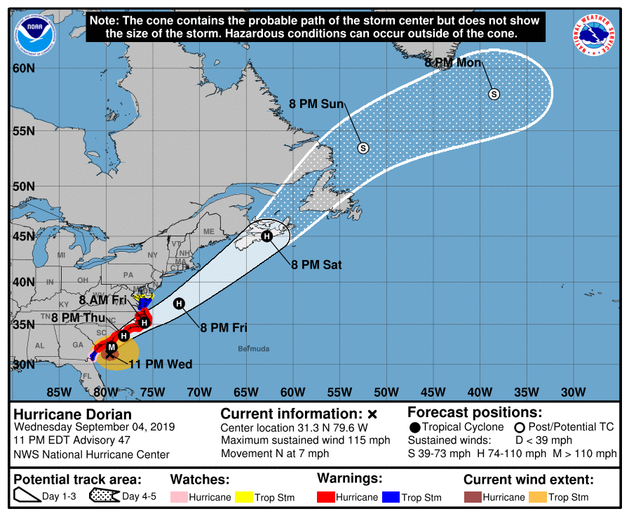
Hurricane Dorian continues to move up the East Coast, and has encountered the Gulf Stream and limited shear. That has allowed it to strengthen over the past several hours back and is now a Category 3 Major Hurricane. Currently located approx. 100 miles south of Charleston, SC.. many models indicate that landfall could occur somewhere between Myrtle Beach and Charleston tomorrow around noon or a couple of hours after. Then the eye wall will move up the coast in some fashion. Whether or not it scrapes the coast, or remains 25-50 miles off the coast will make huge difference. Below you can see the most recent HWRF model run and it has a landfall sometime late tomorrow afternoon.

courtesy of Tropicaltidbits.com
Contact my local trusted roofing source Matt at RedWolf Contracting Services to take care of all of your roof replacements. From shingles, to metal roofing, and even commercial rubber membrane, Matt has the resources and solutions to take care of yo…

Contact my local trusted roofing source Matt at RedWolf Contracting Services to take care of all of your roof replacements. From shingles, to metal roofing, and even commercial rubber membrane, Matt has the resources and solutions to take care of your job in a professional and cost effective manner. Call (828) 772-9778 or visit nc-roofers.com to set up your free roof inspection.

Another short range Hurricane models the HMON also shows a landfall tomorrow around noon between Charleston and Myrtle Beach. Winds could be sustained for 3-6 hours at 100 mph or higher for many beach locations tomorrow afternoon along SC beaches.

Courtesy of Tropicaltidbits.com

Then the storm would move up towards Wilmington late tomorrow evening. The forecast for this storm as to whether it would recurve and miss the coast has been a bit difficult, but I am really beginning to become concerned for both the NC and SC coasts. If these 100mph+ winds translate to the surface and inland, they will cause significant damage to the immediate coast. Beach communities all along the coast need to take evacuations seriously, the time is almost gone for you to leave. Storm surge will be massive will this storm, and will cause problems by flooding many roadways. Some locations could see a 10’+ storm surge. Watch the rendering below and you can see the possibility for track over the next 60 hours. Also, many locations will see over 6” of rainfall from Dorian, further complicating the situation.

courtesy of Tropicaltidbits.com

Impacts

The coastal areas have been preparing for this storm for many days, and it appears that it is coming to fruition. One blessing is that the storm will be moving somewhat faster than it was in the Bahamas, but the winds that could be unleashed will likely do severe damage to structures that are not adequately built. We have not seen a Major Category 3 Hurricane hit the Southeast Coast in nearly 25 years (Fran). The impacts from this will be long felt along many coastal areas, and I hope that the people in those locations have evacuated, or are prepared to experience strong winds over 90mph. Check our Facebook page tomorrow as we share more information regarding the storm!

DorianTrackCloseToCoast.png
212400_5day_cone_no_line_and_wind.png

Hurricane Barry Possible Over Next 48 Hours Along Gulf Coast

many short range models are beginning to show what the European models has hinted at for several days. Currently Potential Tropical Cyclone 2 is located off of the Florida Coast, and will begin to drift west into a more favorable environment for Hurricane development. With limited shear aloft, the atmosphere will be able to stack itself and a decent sized storm could develop. Below you can see the projected path for Potential Tropical Cyclone 2 and the projected intensities provided by the National Hurricane Center.

BerryProjectedPathNHCWednesdayAM.png
Contact my local trusted roofing source Matt at RedWolf Contracting Services to take care of all of your roof replacements. From shingles, to metal roofing, and even commercial rubber membrane, Matt has the resources and solutions to take care of yo…

Contact my local trusted roofing source Matt at RedWolf Contracting Services to take care of all of your roof replacements. From shingles, to metal roofing, and even commercial rubber membrane, Matt has the resources and solutions to take care of your job in a professional and cost effective manner. Call (828) 772-9778 or visit nc-roofers.com to set up your free roof inspection.

Chances of Development

Potential Tropical Cyclone 2 is currently not a Tropical Depression just yet, but there is a 100% of development over the next 2 days according to the National Hurricane Center. This will likely bring flooding to an area that does not need any more water! River levels in the area projected to see the most rainfall are already very high from excessive runoff from an overly wet Spring in the Midwest.

ChanceForDevelopmentBerry (1).png

Flooding Concerns

River levels are now projected to reach almost record high levels as deep tropical moisture moves over areas of Louisiana & Texas. Below you can see the river gauge for The Mississippi in New Orleans and the projected hight that it is supposed to rise to over the next several days. It could reach record high levels! This could bring intense flooding to the area. Flooding is already ongoing, and I believe that it will only get worse through the weekend.

MissiippiNearRecordHighLevelsLA.png
Call the team that keeps my truck clean at A&R Specialist! Matt & Harley run A&R Specialist at 621 Brevard Rd. and they are the guys to trust with your vehicle cleaning & detailing. Whether you need a deep wax every once in a while o…

Call the team that keeps my truck clean at A&R Specialist! Matt & Harley run A&R Specialist at 621 Brevard Rd. and they are the guys to trust with your vehicle cleaning & detailing. Whether you need a deep wax every once in a while or a quality clean and detail, you can feel safe putting your car in the hands of A&R Specialist! Call (828) 708-3718 to set up your appointment today. https://www.facebook.com/ARpressurewashing4/

Model Projections

Several short range models really ramp up this storm and have the pressure deepening into the 970’s. That could be a Category 1 or 2 storm. The fear is that it will be strengthen at landfall and that will maximize localized wind damage. It is still too far out to tell how much development will occur with this system, but locations between Nola & Houston would be wise to prepare. Below are a few short range models images.

Will This Storm Affect WNC?

There is an increasing likelihood that sometime late this weekend or early next week that WNC will see rainfall and some gusty winds from the remnants of whatever develops. Below is what is consider a spaghetti plot off model solutions that show all the various paths that are being manifested. The main takeaway from this image is that there is great uncertainty as to how the storm will interact with a passing trough that could pick it up. If the trough picks it up quickly, it could move towards WNC.. But if the trough leaves it behind, the storm will continue into the interior of the United States.

I will keep you updated regarding how WNC will be impacted by this storm, but just know that it is too far out to tell at this point in time. Until the storm gets its act together, we will have a very limited idea on where exactly it will head.

Warmest May Week Ever Recorded This Week At Asheville Airport

In the 74 years that data has been kept at the Asheville Airport, there has never been a 7-day period in May where the average daily high temperature has been higher! Data obtained from The Southeast Regional Climate Center shows that since last Wednesday, Asheville and surrounding area have experienced record heat. This is astonishing, and we are 3 weeks away from summer! This doesn’t mean that this summer will be excessively hot, but what it does mean is that the high pressure that has setup on top of us has been the most dominate high pressure ever recorded in May. This data was provide by Southeast Regional Climate Center and can be found at this link:http://sercc.com.

The most trusted roofing contractor in WNC is only one call away! Give Matt and the team a chance to evaluate your roof for free! Call (828)772-9778 or visit their website nc-roofers.com to set up your appointment today!

The most trusted roofing contractor in WNC is only one call away! Give Matt and the team a chance to evaluate your roof for free! Call (828)772-9778 or visit their website nc-roofers.com to set up your appointment today!

Relief Is On The Way

Cooler temperatures and highs only in the 70’s are likely this weekend as this dome of high pressure finally breaks down. Some showers will also be possible with chances increasing into early next week. That will be nice since this past week was tied for the driest May period on record as well. I will have a full update on shower potential moving into the weekend in the coming days, so check back soon and have a great day!

Knoxville Recycling Plant Fire Large Enough To Be Detected By Radar

A fire that is currently ongoing at a Knoxville, Tennessee recycling plant is producing a smoke plume that is large enough to be detected by radar.  Local news outlets (WVLT) are reporting that the fire could have been cause by a machine spark.  All 25 employees have safely been evaluated, but the fire is still burning and being picked up by radar.  More info to come when it becomes available. 

IMG_6551.GIF
IMG_6552.PNG
FullSizeRender.jpg

At aprox 5:30pm the Knoxville Fire Department reported that the fire was still burning and evacuations were still in place for the immediate area.

Today Was The Wettest Day In Over 100 Years Across WNC, Top 3 All-Time

With 5.22” of rainfall recorded today at the Asheville airport, today will rank in the top three wettest days ever in Asheville. In fact it has been the wettest day since October 25th, 1918! This brought flash flooding to many locations around the Asheville area. Below are social media photos that we're posted to AshevilleWX’s Facebook page.

Amboy Rd. sent in by Paula Hayes

Photo from Hendersonville, NC sent in by Missy Barnwell

Canton, NC Flooding sent in by Steve & Darla Brown

Call Matt at (828)772-9778 for all your roofing repair needs and tell him that Hunter sent you!

Call Matt at (828)772-9778 for all your roofing repair needs and tell him that Hunter sent you!

Jessica Lewis sent in this photo of flooding on Highway 64

Jessica Lewis sent in this photo of flooding on Highway 64

Another photo from Highway 64 sent in by Jessica Lewis

Time-lapse sent in by Holly Harwood form Biltmore, NC

Biltmore, Sent in by Dennis Buck

Biltmore, Sent in by Dennis Buck

Water Rescue sent in by Claire Stauchan Poole

Water Rescue sent in by Claire Stauchan Poole

Drone Video of the French Broad River and Carrier Park today from Daren Gummy.

Please send in your photos of flooding around the area to have them added to the article! Hunter@ashevillewx.com

Snow Showers Cant Be Ruled Out Tomorrow Around WNC

After this dynamic system dropped over 5” of rainfall for many in WNC, the backside will bring the chance for snow showers for some tomorrow morning. Below you can see a depiction a the most recent NAM 3km, and it shows some snow showers building in SW WNC tomorrow morning. I am still not certain exactly where this band will set up, but it does appear that some snowflakes will be possible below 3000’ in isolated valleys. High elevation locations(above 4500’) will likely see a few inches of snow accumulation.. but that will melt off quickly by Sunday. All and all this appears to be somewhat of a low impact backside event, but some surprise snowflakes are certainly possible. Below you can see the most recent Nam 3km precipitation depiction.

Call Matt at (828)772-9778 and tell him that Hunter sent you or visit their facebook page here!

Call Matt at (828)772-9778 and tell him that Hunter sent you or visit their facebook page here!

18z Nam 3km Precipitation Depiction Courtesy of Weathermodels.com

Temps Rebound Into The 60’s Sunday

Don’t cancel the Easter plans just yet! Models show temperatures rebounding into the upper 50’s or lower 60’s! After this upper level low exits, so will the cold temperatures and next week will be nice to begin the week. Be sure to check the AshevilleWX Weather Cameras tomorrow morning to see if and where snow is falling. Have a great weekend!

Strong Storms Bring Accumulating Hail To Downtown Brevard, NC On Tuesday

At around 2:20pm this afternoon, a strong thunderstorm developed over Brevard, NC and dropped dime to quarter sized hail across the majority of the city. Below you can see the radar grab from when the storm developed along with the precipitation classification (red=hail).

Social Media Posts

Video Courtesy of Laura Leatherwood.

Photo Courtesy of Laura Leatherwood

Photo Courtesy of Laura Leatherwood

Photo Courtesy of Laura Leatherwood

Tax Time Is Now

Call the local professionals at C.P. Kruse to handle your tax prep. It’s not too late! Call (828)684-7374 or visit kruseaccounting.com

Photo Courtesy of Carla Berkshire Posted to AshevilleWX Facebook Page

Photo Courtesy of Melissa Ashe posted to AshevilleWX Facebook Page

Photo of Downtown Brevard, NC Posted on The AshevilleWX Facebook Page By Alissa Puckett

Hail also fell in other places around WNC including Highway 441 on Cowee Mountain. Felicia Garrett Troyer sent in this video of traffic pulled off to the side of the road between Sylva & Franklin, NC.

It's Snowing This Morning Around Wilmington, NC

Mping reports are show snow falling just west of Wilmington, NC this morning.. and many locations in SE NC experience a dusting of snowfall overnight. Below you can see the radar scan with an Mping report of snow just west of town. Scanning around social media, and you can see that locations like Lumberton, NC, & Whiteville , NC received a dusting of snow from this coastal low development. These snow showers will move out of the area in the next 6 hours, but it is still neat to see snow falling along the coast of NC!

Tax Time Is Now!

Set up your appointment today with the best accountants in WNC. Call (828)684-7374 or visit Kruseaccounting.com to set up your appointment today!

Mud Slide Occurs On US 74 In Jackson Co. West Bound Lanes Blocked

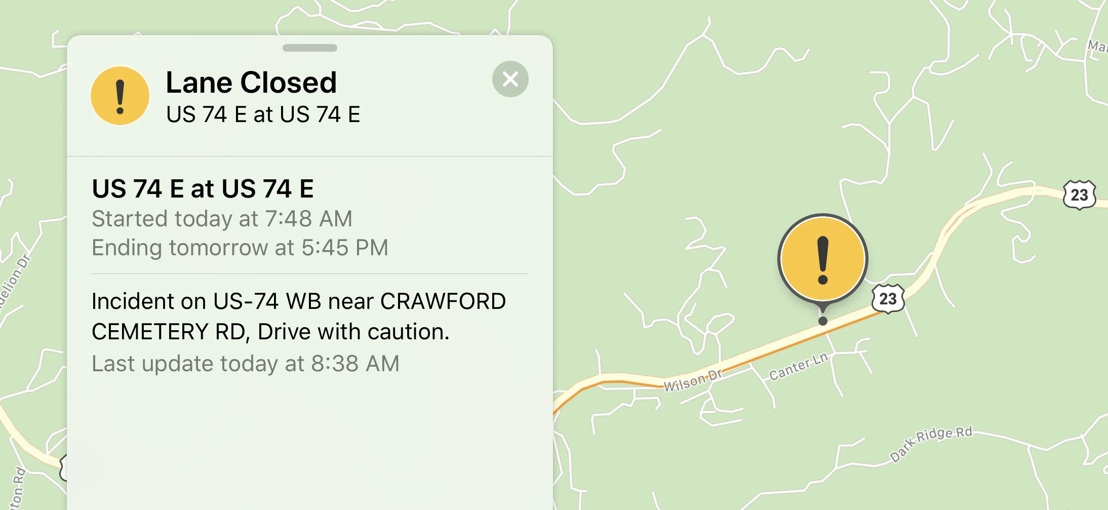
A mud slide has occurred this morning around 7:30am on US 74 in Jackson Co. Currently crews are assessing the situation, and clean up should begin shortly. It is undetermined how long exactly the cleanup will take, but the west bound lanes could be closed for a couple of days. Below are photos sent in by AshevilleWX viewer Amber Hannah.

IMG_6330.jpg

It’s Tax Time

Trust the best in the business at C.P. Kruse with your tax preparation this year. Call them at (828)684-7374 or visit their website kruseaccounting.com to set up your appointment today!

Detour

It appears that Skyland Dr. can be taken to and from Sylva, by way of Dark Ridge Rd., but I will need some to verify that for me. Please be patient and allow crews time to properly secure the slope before traffic resumes.


I-40 To Be Closed For The Next Week For Rock Slide Clean Up, Use I-26 to I-81

NC Dot has released a tweet stating that they will need one week to safely clean up the 500ft area where rocks have slide onto I-40. Then the traffic will be slow going with only 1 lane open on each side for the next 6-8 weeks.

Other Slides Cant Be Ruled Out

Rainfall will continue through the next day or so, but the front will finally move through Sunday afternoon. Winds will pick up around WNC and some higher elevation locations could see gusts over 50mph Sunday afternoon and into Monday. Slopes around the area are very weak, and high winds could bring down trees all across the area.

Go With The Local Experts

C.P. Kruse is the trusted local company to chose this year for your tax preparation! Call them at (828)684-7374 or visit their website at kruseaccounting.com to set up your appointment, and tell them Hunter sent you!

High Winds Create Power Outage Concern

With the soil so wet around the area, winds that are gusting above 35mph will bring trees down all across WNC. Please be mindful of this, and know that you could lose power over the next 36 hours. Below you can see the most recent Nam 3km wind gust map on Sunday afternoon.

projectedwindssundayfeb24th2019.png

Cold Returns Next Week

Cananda air will move into WNC on Monday morning, and we will once again dip below freezing. In fact, some locations could dip well below freezing and into the mid 20’s. This will cause problems with trees that have been fooled into believing it is already Spring. I am worried that tree blooms this year are going to suffer, because much of March looks to be setting up to be below average. I have my eye on next week, and long range models are hinting at the potential for another storm, but thats all I will say about it for now. Stay tuned to AshevilleWX, and check back soon for another update!

Rock Slide Closes I-40 In Both Directions, More Rain On The Way

A rock slide occurred on I-40 last night around 7:30pm between exits 7 and exits 20. Both lanes are current closed at this point in time and traffic is being detoured on I-26 to I-81 near Johnson City. Please find an alternative route if you have plans to travel through the Gorge today.

Slide Area

Tax Season Is Here

Why not trust the best in town at C.P. Kruse with your taxes this year?? Give them a call (828)684-7374 or visit Kruseaccounting.com to set up your appointment today!


More Rain Moving In

Crews will not get any help today with rainfall continuing to move through the area. Showers will be heavier along the NC/TN border, so that will not help the situation either. I expect for that location to receive another two inches of rainfall today if not more. Until rokks stop moving, cleanup will struggle to progress. Until rainfall stops, rocks will likely continue to move. Below you can see the most recent Nam 3km. I have circled the slide area.

More Slides Could Occur

The ground is extremely saturated around WNC, and that will only get worse over the next two days. Rainfall will finally move out of the area late Sunday, but it will take several days for WNC to dry out. Honestly the ground is as soggy as I can every remember it begins around WNC. Most everywhere you step in grass, it leaves a footprint. The creeks are all at bank-full and even a drizzle causes ponding on the roadways. Please be careful driving around WNC today, and report any flooding you see to the AshevilleWX Community on Facebook.

Heavy rainfall moving into slide area again

4”+ of rainfall has fallen over slide area in past several days


Slick Roadways Cancel Some Schools Around WNC

Freezing rain began across portions of WNC early this morning, and has made for a tricky commute around the area for many. Many wrecks have been reported around Henderson Co. where schools have been closed for the day due to slick roadways. The Reynolds & Roberson districts in Buncombe County will also be closed today due to slick roadways. Temperatures will climb into the lower 50’s later today as the frontal passage approaches, so if you have slick roadways in your area, stay put until temperatures rise. Heavy rain is expected to push through the area late Wednesday night and into Thursday with over 1.5” of rainfall possible in many areas. Some flash flooding cannot be ruled out with this system. Looking ahead towards the weekend, the sun will return! Temperatures will push into the 40’s each day with lows in the mid 20’s. Please have a great day and stay safe traveling around the area this morning!

Photo of wreck in Fletcher, NC due to icy roadway provided by Tamela Davis Rich Fanning Bridge Rd. at Hendersonville Highway

Photo of wreck in Fletcher, NC due to icy roadway provided by Tamela Davis Rich Fanning Bridge Rd. at Hendersonville Highway

Tax Time Is Here!

Beat the rush and schedule your tax appointment today with the trusted local pros at C.P. Kruse & Co. Give them a call at (828) 684-7374 or visit their website for more info. http://www.kruseaccounting.com

Newfound Rd. In Leicester provided by Cherrie Moody Grindstaff

Newfound Rd. In Leicester provided by Cherrie Moody Grindstaff

Many Rain Gauges IN WNC Top 100" Of Rain For 2018

Data continues to come in regarding the record rainfall year of 2018 in WNC, and I wanted to share some interesting maps that NOAA has generated. Below you can see the total estimated radar rainfall for the year of 2018. As you can see, many locations along the Blue Ridge Escarpment received over 100” of rainfall. Even in Buncombe Co. some gauges in Fairview & Black Mountain topped the 100” mark. The wet pattern looks to continue into 2019, but hopefully we can experience some drying over the next week that will minimize flash flooding threats!

The Best In Town

Tax preparation time is upon us so why not set up your appointment with the trusted local professionals at C.P. Kruse & Co. call (828) 684-7274 or visit http://www.kruseaccounting.com