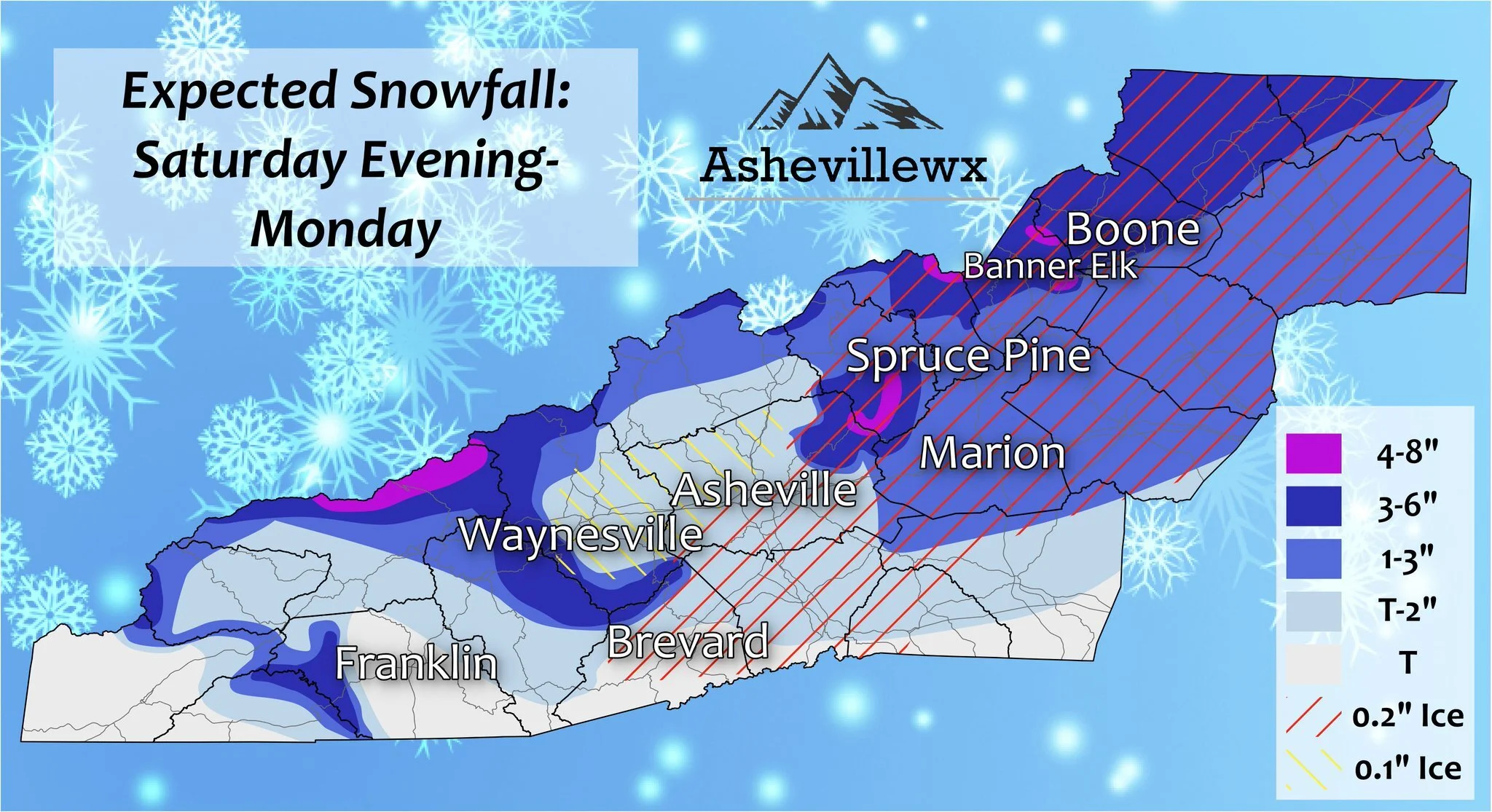
A three part storm will affect WNC over the next couple of days, and each facet will have its own interesting weather features as the traverse the area. The initial batch of precipitation will push through the mountains around 4pm-6pm today bring the chance for a rain to snow mix for many valley locations. Elevations above 3500’ will likely see all snow from this, and a quick dusting to 1” could be possible. Then after midnight tonight, the second wave of precipitation will move through. This could cause some driving problems early Sunday morning around WNC, with ice mixing in with snow. Locations in SW WNC will be too warm to see this mix, but as you progress toward the Northern Blue Ridge Escarpment conditions will dramatically go downhill. Snow & sleet will hang on in locations like Hendersonville & Marion even after the sun rises on Sunday morning. 1”-3” of slush could accumulation along the Escarpment areas and into the Northern Piedmont. This will be due to proximity to the cold air source. Locations in SW WNC are much farther away compared to locations like Marion & Hickory. Following this second batch of moisture, focus will turn to the Northwest flow that will follow. Check out my projected map below that Evan has produced. I’ll go more into detail about the NWF snow below.
Contact my local trusted roofing source Matt at RedWolf Contracting Services to take care of all of your roof replacements. From shingles, to metal roofing, and even commercial rubber membrane, Matt has the resources and solutions to take care of your job in a professional and cost effective manner. Call (828) 772-9778 or visit nc-roofers.com to set up your free roof inspection.
We're here to help reduce the use of single-use plastics by offering bulk refills of household needs. Come refill your empty containers (shampoo bottles, hand soap dispensers, laundry detergent containers, jars etc) with our more natural products and pay by the ounce! To The Brim Click Here
Model Data
Let’s check out the most recent HRRR model below. You can see that initial tongue of precipitation moving through later this afternoon, then as Sunday begins, moisture arrives on the NC/TN border.. It takes some time to erode away the surface cold layer in many areas, and that means ice will be likely. As you progress into the Northern Mountains, snowfall levels will not be affect. Most initial precipitation will not mix with rain above 3500’, and should fall as a sleet/snow mix. That is why totals will be increased Northeast of Asheville.
HRRR Model Courtesy of Pivotalweather.com
The trusted local accounting firm for WNC, let the team of Adrianne, Caroyl, & Naomi take care of all of your tax needs. Whether you need payroll/business accounting help or assistance filing your personal taxes, these ladies are the experts to put your trust with. Give them a call (828) 684-7374 or visit their website http://www.kruseaccounting.com to set up your appointment today!
NAM 3km Model Data
I always like to show multiple model sources when discussing a winter event, so lets look at the NAM 3km as well. It shows that initial band of precipitation moving in around 3pm-6pm. Then just like the HRRR it brings heavy precipitation back Sunday morning. Roadways could be treacherous early Sunday morning. It would be wise to wait until your locations switches to rain before attempting to move around town.
Nam 3km Courtesy of Weathermodels.com
Come to where Mother Nature waved her magic wand and created one of the most natural of all wonders, Natural Hot Mineral Waters. Heated deep within the earth, these crystal clear carbonated waters are are world famous for their mineral content and legendary healing powers. We pipe these waters to modern outdoor jetted hot tubs that we rent privately by the hour. In addition to our World Famous Natural Hot Mineral baths the day spa offers massage, body treatments, and skin care options. Hot Springs Resort also offers accommodations and camping options. Please visit http://www.nchotsprings.com for more information.
Northwest Flow Snow To Bring Another Round Of Accumulation To WNC Monday
The backside of this storm appears to be very strong, and could be one of our best Northwest flow setups of the year. Locations above 3500’ could easily see another 2”-4” from this flow, with locations above 5000’ seeing another 3”-6” of snow. Valley locations will also get in on the snowfall action, especially North of I-40. A couple of inches can’t be ruled out for valley locations like Maggie Valley, and even a dusting to 2” will be possible in Waynesville & Canton. Madison County should also do well from this flow with similar totals to Haywood being found in Madison. For Buncombe County North of I-40 I am expecting a dusting to 1” of snowfall accumulation from this flow. South of Asheville a dusting will be possible. These totals may need to be adjusted as I get more data, but that’s my best guess at the moment. Below you can see the NAM showing the flowing moving through.
Call the team that keeps my truck clean at A&R Specialist! David, Matt & Harley run A&R Specialist at 621 Brevard Rd. and they are the guys to trust with your vehicle cleaning & detailing. Whether you need a deep wax every once in a while or a quality clean and detail, you can feel safe putting your car in the hands of A&R Specialist! Call (828) 708-3718 to set up your appointment today. https://www.facebook.com/ARSpecialistsLLC
NAM Courtesy of Pivotalweather.com


