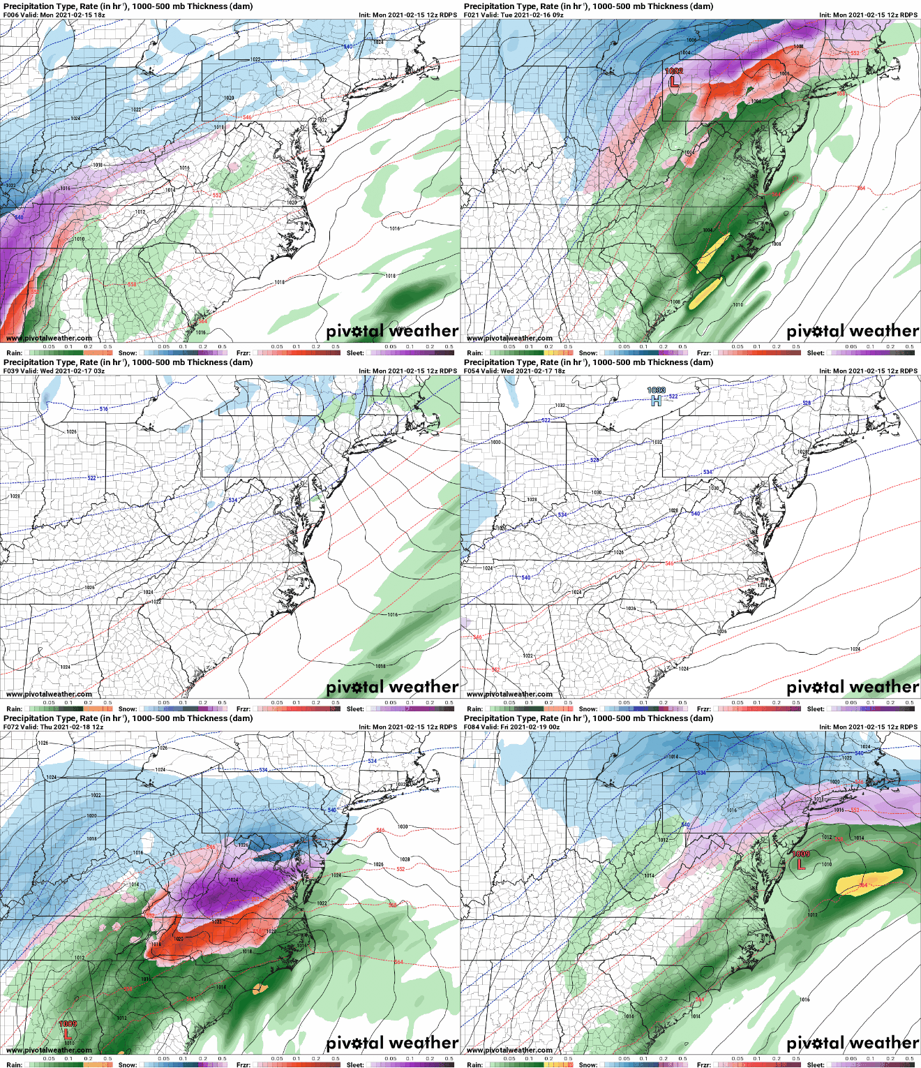
After several rounds of rainfall have moved through WNC without causing any problems, it appears high pressure will finally move into place on Thursday morning and icing could occur. As the high pressure to our North moves over the Northeast, cold air will funnel into areas where cold air is known to dam up. This is called cold air damming. CAD or cold air damming can create for icy conditions all across the Mountains of WNC depending on how strong the cold air source is. Looking at short range models, this cold air source seems to be significant and could cause problems around WNC on your Thursday commute.
Call the team that keeps my truck clean at A&R Specialist! David, Matt & Harley run A&R Specialist at 621 Brevard Rd. and they are the guys to trust with your vehicle cleaning & detailing. Whether you need a deep wax every once in a while or a quality clean and detail, you can feel safe putting your car in the hands of A&R Specialist! Call (828) 708-3718 to set up your appointment today. https://www.facebook.com/ARSpecialistsLLC
Model Spread
Below you can see the most recent Canadian short range model. This is the most aggressive of the short range models, but does show the possibilities that we could be dealing with. Temperatures will likely fall into the upper 20’s early Thursday morning right before precipitation moves in. Icing will be possible in locations that struggle to push above freezing. Locations in SW WNC like Franklin & Murphy will warm up much quicker compared to Hendersonville & Brevard where icing could last into the mid morning hours. I have also put the map in motion for your pleasure below.
Short Range Canadian Model Courtesy of Pivotalweather.com
Contact my local trusted roofing source Matt at RedWolf Contracting Services to take care of all of your roof replacements. From shingles, to metal roofing, and even commercial rubber membrane, Matt has the resources and solutions to take care of your job in a professional and cost effective manner. Call (828) 772-9778 or visit nc-roofers.com to set up your free roof inspection.
Short Range Canadian Courtesy of Pivotalweather.com
We're here to help reduce the use of single-use plastics by offering bulk refills of household needs. Come refill your empty containers (shampoo bottles, hand soap dispensers, laundry detergent containers, jars etc) with our more natural products and pay by the ounce! To The Brim Click Here
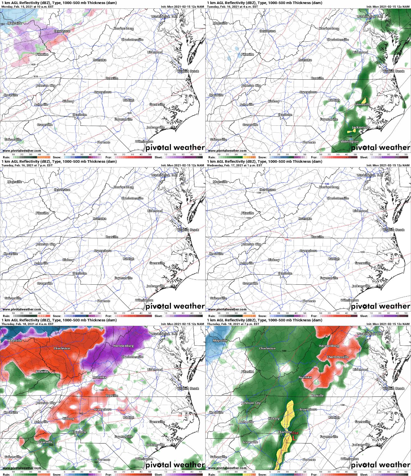
Now let’s take a look at the most recent NAM model and what it depicts. Keep in mind that both of these models are showing some form of icing for a portion of WNC. 1-2 degrees of temperature disparity could cause wildly different results across portions of the area. Locations just a couple of miles down the road from your home can be colder, and their conditions could be must different. Keep this in mind when you are traveling around the area on Thursday. Just because you do not have ice at your house, doesn’t mean that locations to your south, east, or north might not.
The trusted local accounting firm for WNC, let the team of Adrianne, Caroyl, & Naomi take care of all of your tax needs. Whether you need payroll/business accounting help or assistance filing your personal taxes, these ladies are the experts to put your trust with. Give them a call (828) 684-7374 or visit their website http://www.kruseaccounting.com to set up your appointment today!
NAM Courtesy of Pivotalweather.com
Come to where Mother Nature waved her magic wand and created one of the most natural of all wonders, Natural Hot Mineral Waters. Heated deep within the earth, these crystal clear carbonated waters are are world famous for their mineral content and legendary healing powers. We pipe these waters to modern outdoor jetted hot tubs that we rent privately by the hour. In addition to our World Famous Natural Hot Mineral baths the day spa offers massage, body treatments, and skin care options. Hot Springs Resort also offers accommodations and camping options. Please visit http://www.nchotsprings.com for more information.
Projected Ice Totals
Below you can see the ice projection from the most recent NAM model run. These totals should be taken with a grain of salt, but the possibility is there for a medium impact icing event for locations along the Blue Ridge Escarpment. That would include locations like Highlands, Lake Toxaway, Brevard, Hendersonville, Flat Rock, Chimney Rock, Bat Cave, Black Mountain, Spruce Pine, Boone and surrounding areas.
NAM Courtesy of Pivotalweather.com
NAM ice totals courtesy of Pivotalweather.com
Lots Of Detail Remain To Be Hammered Out
I am continuing to watch this progression of moisture and evolution of high pressure as we work towards Thursday. I will have another article detailing out the possibility for ice on Thursday later this week when I have more information on what exactly will unfold. Check back soon!


