Flash Flooding Likely Today & Tomorrow Around WNC As Heavy Rain Moves In

Heavy Rain, Flash Flooding Possible Friday & Saturday around WNC

I am becoming increasingly concerned about the threat for flash flooding around WNC this afternoon and tomorrow around WNC. A stalled frontal boundary has inundated the South and a large swath of moisture is currently moving across Tennessee. This will eventually make it to WNC. Isolated locations could see 2”+ of rain fall very quickly. Many locations already have saturated ground so this will make for a dangerous situation as rain continue to fall. Storm could also train over some areas and that will enhance flooding. Below you see the most recent NAM 3km model precipitation depiction.

Contact my local trusted roofing source Matt at RedWolf Contracting Services to take care of all of your roof replacements. From shingles, to metal roofing, and even commercial rubber membrane, Matt has the resources and solutions to take care of your job in a professional and cost effective manner. Call (828) 772-9778 or visit nc-roofers.com to set up your free roof inspection.

HRRR image provided by Pivotalweather.com

Models Vary, Heavy Swath of Rain Possible Around WNC

Short range models are really struggling with the variation in precipitation around the area. It appears to me as though isolated heavy rain bands are going to pop up this afternoon and right now it appears they favor the northern portion of Buncombe County. Some models show over 2” of rain falling very quickly. Isolated flash flooding will happen quickly where these storms develop so please do not proceed into flood covered roadways!

Report Flash Flooding To Social Media

If you see flooding around WNC please tag me on any social media channel. The links are below!

Winter Weather Returns To WNC Early Saturday Morning, Accumulating Snowfall Likely For Many

Projected Snowfall Total Map For March 12th

The trusted local accounting firm for WNC, let the team of Adrianne & Caroyl take care of all of your tax needs. Whether you need payroll/business accounting help or assistance filing your personal taxes, these ladies are the experts to put your trust with. Give them a call (828) 684-7374 or visit their website http://www.kruseaccounting.com to set up your appointment today!

Snowfall To Return Early Saturday AM

Snowfall will begin early tomorrow morning around 4am and persist through the noon. As the front moves through rain will switch to sleet and then snow likely while you are sleeping. Many around WNC could wake up to a quick burst of snowfall that coats everything. Check out the most recent 3km NAM below.

Contact my local trusted roofing source Matt at RedWolf Contracting Services to take care of all of your roof replacements. From shingles, to metal roofing, and even commercial rubber membrane, Matt has the resources and solutions to take care of your job in a professional and cost effective manner. Call (828) 772-9778 or visit nc-roofers.com to set up your free roof inspection.

Varying Model Accumulation Projections

Below I will detail out all of the various accumulation maps that I have to work from. You’ll see the GFS, EURO, NAM3km, & HRRR models. I have taken a blend of these to produce my forecast.

GFS Model

GFS Courtesy of Weathermodels.com

As you start thinking about your next vacation, make sure your plans include TIME TO TRAVEL. Our services are free and our travel advisors will assist every step of the way from planning your dream vacation, to keeping you up to date on the constant changes in travel protocols. Time to Travel is an Authorized Disney Vacation Planner, a Certified Universal Orlando Resort Specialist as well as a Preferred Sandals Agency. We would love to book your next vacation regardless of the destination. We make the Plans, You make the memories. Click Here!

European Model

Euro Snowfall Map Courtesy of Weathermodels.com

NAM 3km

NAM 3km Courtesy of Weathermodels.com

HRRR Model

HRRR Snowfall Map Courtesy of Weathermodels.com

High Winds & Bitter Cold To Be Story Into Sunday

Winds will pick up considerably during the day on Saturday as Northwest flow moves through. Some locations could see gusts over 40mph. Then temperatures will plummet into the mid teens around the area early Sunday morning. I expect temps to recover into the low 50’s Sunday afternoon, but winds will still be somewhat gusty. Make sure to cover any sensitive vegetation because this cold has the potential to kill things that have already budded.

Upper Level Low & Backside Northwest Flow To Bring Snow To WNC Friday Night & Saturday

Projected Snowfall Total Map For January 28th-29th

As you start thinking about your next vacation, make sure your plans include TIME TO TRAVEL. Our services are free and our travel advisors will assist every step of the way from planning your dream vacation, to keeping you up to date on the constant changes in travel protocols. Time to Travel is an Authorized Disney Vacation Planner, a Certified Universal Orlando Resort Specialist as well as a Preferred Sandals Agency. We would love to book your next vacation regardless of the destination. We make the Plans, You make the memories. Click Here!

The trusted local accounting firm for WNC, let the team of Adrianne & Caroyl take care of all of your tax needs. Whether you need payroll/business accounting help or assistance filing your personal taxes, these ladies are the experts to put your trust with. Give them a call (828) 684-7374 or visit their website http://www.kruseaccounting.com to set up your appointment today!

Current Model Trends

The most recent NAM 3km is suggesting a more robust deformation feature that stays over WNC from around 5pm-9pm. That would be 3-4 hours of heavy snowfall for many on Friday evening. If this comes to fruition some may see higher total compared to what I am projecting now. Check out the simulated radar from the most recent NAM 3km below.

NAM 3km Courtesy of Weathermodels.com

Contact my local trusted roofing source Matt at RedWolf Contracting Services to take care of all of your roof replacements. From shingles, to metal roofing, and even commercial rubber membrane, Matt has the resources and solutions to take care of your job in a professional and cost effective manner. Call (828) 772-9778 or visit nc-roofers.com to set up your free roof inspection.

NAM 3km Snowfall Projection Map

Below you can see the most recent depiction of snowfall as well. Watch as the map populates near the end of the frame run. This is around sundown on Friday evening. I think that sundown will be key for accumulation to occur around WNC. The more snow that falls at your location after the sun sets on Friday will equate to more accumulation with less melt occurring. I think that locations South of Asheville like Hendersonville have a good shot to see 3-4 hours of heavy snow.

Snowfall Map Courtesy of Weathermodels.com

Winds To Be A Factor Into Saturday

High wind gusts around 30 mph will be possible as the Upper Level Low moves through. Then winds could again pick up as the Northwest flow enhances. Here is the peak wind gusts projected for the WNC area as the bulk of the precip moves through WNC. Check back for more info as I continue to monitor this storm!

Updated Projected Snowfall Map, High Winds Will Be Problematic Sunday.. Power Outages Likely

Updated Projected Snowfall Total Map For January 16th-17th

The trusted local accounting firm for WNC, let the team of Adrianne & Caroyl take care of all of your tax needs. Whether you need payroll/business accounting help or assistance filing your personal taxes, these ladies are the experts to put your trust with. Give them a call (828) 684-7374 or visit their website http://www.kruseaccounting.com to set up your appointment today!

Contact my local trusted roofing source Matt at RedWolf Contracting Services to take care of all of your roof replacements. From shingles, to metal roofing, and even commercial rubber membrane, Matt has the resources and solutions to take care of your job in a professional and cost effective manner. Call (828) 772-9778 or visit nc-roofers.com to set up your free roof inspection.

High Winds To Be A Problem

We can focus on snowfall totals, but the main concern here are the high winds on the backside as the Upper Level Low moves through. Some trees could have 9”+ of frozen precipitation coating them with winds gusting over 40mph. This is a serious recipe for power outages. Check out the wind map at the peak from the most recent HRRR model.

HRR Wind Gusts Courtesy of Pivotalweather.com

Time Running Out To Prep

There are several more hours for preparation but this storm looks to begin around WNC at 10pm or so. The highest wind gust will be around 6am so there will be no time to prep tomorrow. Things like filling up a bath tub to flush toilets if you have a well, and getting alternative heat are all things to think about. Be safe!!

Major Winter Storm Expected For WNC Sunday & Into Monday AshevilleWX Initial Projected Snowfall Totals

Major Winter Storm To Affect WNC Sunday & Into Monday

Contact my local trusted roofing source Matt at RedWolf Contracting Services to take care of all of your roof replacements. From shingles, to metal roofing, and even commercial rubber membrane, Matt has the resources and solutions to take care of your job in a professional and cost effective manner. Call (828) 772-9778 or visit nc-roofers.com to set up your free roof inspection.

Long Range Models Show Major Storm, Short Range Models Beginning To Hone In

GFS

GFS Courtesy of Pivotalweather.com

The trusted local accounting firm for WNC, let the team of Adrianne & Caroyl take care of all of your tax needs. Whether you need payroll/business accounting help or assistance filing your personal taxes, these ladies are the experts to put your trust with. Give them a call (828) 684-7374 or visit their website http://www.kruseaccounting.com to set up your appointment today!

European Model

European Courtesy of Pivotalweather.com

NAM Courtesy of Pivotalweather.com

Dry Slot Of Concern For Snow Lovers In WNC

So short range models are showing a dry slot that could develop during the storm around WNC that could cut down on overall snowfall totals. My snowfall totals may need to adjust to compensate for now, but there is good agreement among models that most will see over 6” of snowfall. I will keep watching the dry slot progression and keep you updated!

Double Shot Of Snowfall Possible For WNC Thursday Night & Then Saturday Night Into Sunday

Two Chances For Snowfall Around WNC Over Next 7 Days

A weak front will push through WNC on Thursday evening, bring with it the chance for snow showers especially on the NC/TN border above 3500’. I am expecting 2”-4” of accumulation for those above 3500’ and a dusting could even be possible for some valley locations. Then I am tracking a Gulf Low that will develop sometime on Saturday and move towards WNC late Saturday night. Below I will detail out both events and show you what the models are showing for each system.

The trusted local accounting firm for WNC, let the team of Adrianne & Caroyl take care of all of your tax needs. Whether you need payroll/business accounting help or assistance filing your personal taxes, these ladies are the experts to put your trust with. Give them a call (828) 684-7374 or visit their website http://www.kruseaccounting.com to set up your appointment today!

Thursday Night Storm

A weak low will move through WNC beginning Thursday afternoon. With cold in place, many areas could see rain switch to snowfall as the system moves through. Low end totals are expected around Asheville with a dusting to 1” seeming like a reasonable forecast as of now. For locations closer to the NC/TN border those totals will increase as NWF picks up on Friday am. Above 3500’ I believe 2”-4” of snowfall will be possible. Below check out the depiction from the 6z GFS.

6z GFS Courtesy of Pivotalweather.com

European Model Thursday Event

The European model is less amped with this system and is not as optimistic about snowfall potential. However it does still have the threat for many around WNC. Check out the European model below, it shows a 1”-3” event for above 3500’ and then just a few flurries on the backside for Asheville. I tend to think the GFS has a better handle on this solution and looks similar to the NAM when compared.

6z Euro Courtesy of Pivotalweather.com

Contact my local trusted roofing source Matt at RedWolf Contracting Services to take care of all of your roof replacements. From shingles, to metal roofing, and even commercial rubber membrane, Matt has the resources and solutions to take care of your job in a professional and cost effective manner. Call (828) 772-9778 or visit nc-roofers.com to set up your free roof inspection.

Saturday-Sunday Gulf Low

Models have been throwing around a lot of energy here recently in regards to a system that looks to move through WNC on Saturday night and through the day on Sunday. The GFS has a classic Gulf low track on its most recent run that hammers WNC with over a foot of snowfall. The European model is weaker with the system and a bit quicker, it also is late on the phase compared to the GFS that brings the big snowfall totals to WNC. The main takeaway here is that the threat for a significant winter storm is increasing for all of WNC this weekend. Below take a look at the progression of the system on both the GFS and European models. I won’t show those large snowfall totals that the GFS just spit out because it could cause confusion, but know this storm has the potential to be a large winter weather producer over all of NC.

GFS

GFS Courtesy of Pivotalweather.com

European Model

European Model Courtesy of Pivotalweather.com

Lots More Info To Come Stay Tuned

Snowfall Possible Tomorrow Around WNC, Accumulation Possible For Many

Weak Low & Backside Northwest Flow To Bring Snow

Who gets snow exactly is uncertain of course, but below is my best guess as to where exactly accumulation of snowfall could occur tomorrow. This storm will persist into the wee hours of Friday morning for many as temperatures crash into the teens and northwest snowfall moves in. I expect roadways in many locations to become snow covered late Thursday night and that will cause problems for travel around WNC on Friday am. Above is my lastest video with a detailed look at the most recent models. I have also attached a gif of the most recent GFS model run below as weak as my projected snowfall map.

Contact my local trusted roofing source Matt at RedWolf Contracting Services to take care of all of your roof replacements. From shingles, to metal roofing, and even commercial rubber membrane, Matt has the resources and solutions to take care of your job in a professional and cost effective manner. Call (828) 772-9778 or visit nc-roofers.com to set up your free roof inspection.

The trusted local accounting firm for WNC, let the team of Adrianne & Caroyl take care of all of your tax needs. Whether you need payroll/business accounting help or assistance filing your personal taxes, these ladies are the experts to put your trust with. Give them a call (828) 684-7374 or visit their website http://www.kruseaccounting.com to set up your appointment today!

GFS Courtesy of Pivotalweather.com

7am Friday AM Temps Courtesy of Pivotalweather.com

Updated Snowfall Projection Map.. Thundersnow Possible For Some In WNC Monday AM

The trusted local accounting firm for WNC, let the team of Adrianne & Caroyl take care of all of your tax needs. Whether you need payroll/business accounting help or assistance filing your personal taxes, these ladies are the experts to put your trust with. Give them a call (828) 684-7374 or visit their website http://www.kruseaccounting.com to set up your appointment today!

Winter Storm Warnings Up, Thundersnow Possible

A more clear picture is beginning to be painted by model data and higher end snowfall total are coming to fruition. We will battle warm ground temps here in WNC, but high rates will overcome those warm ground temps eventually. Below is my most recent snowfall map. I also go in-depth in my video above regarding what to expect over the next 24 hours.

Contact my local trusted roofing source Matt at RedWolf Contracting Services to take care of all of your roof replacements. From shingles, to metal roofing, and even commercial rubber membrane, Matt has the resources and solutions to take care of your job in a professional and cost effective manner. Call (828) 772-9778 or visit nc-roofers.com to set up your free roof inspection.

AshevilleWX Projected Snowfall Map January 2nd-3rd

Threat Increasing For Accumulating Snowfall Late Sunday Night/Early Monday Morning

Models continue to struggle with the approaching frontal passage, but a common theme among models is the first chance at accumulating snowfall for many in WNC. Below is my initial projected snowfall map for this event. I will likely tweak this again before tomorrow night, but these are my thoughts on accumulation through early Monday morning around WNC.

Contact my local trusted roofing source Matt at RedWolf Contracting Services to take care of all of your roof replacements. From shingles, to metal roofing, and even commercial rubber membrane, Matt has the resources and solutions to take care of your job in a professional and cost effective manner. Call (828) 772-9778 or visit nc-roofers.com to set up your free roof inspection.

Model Discussion

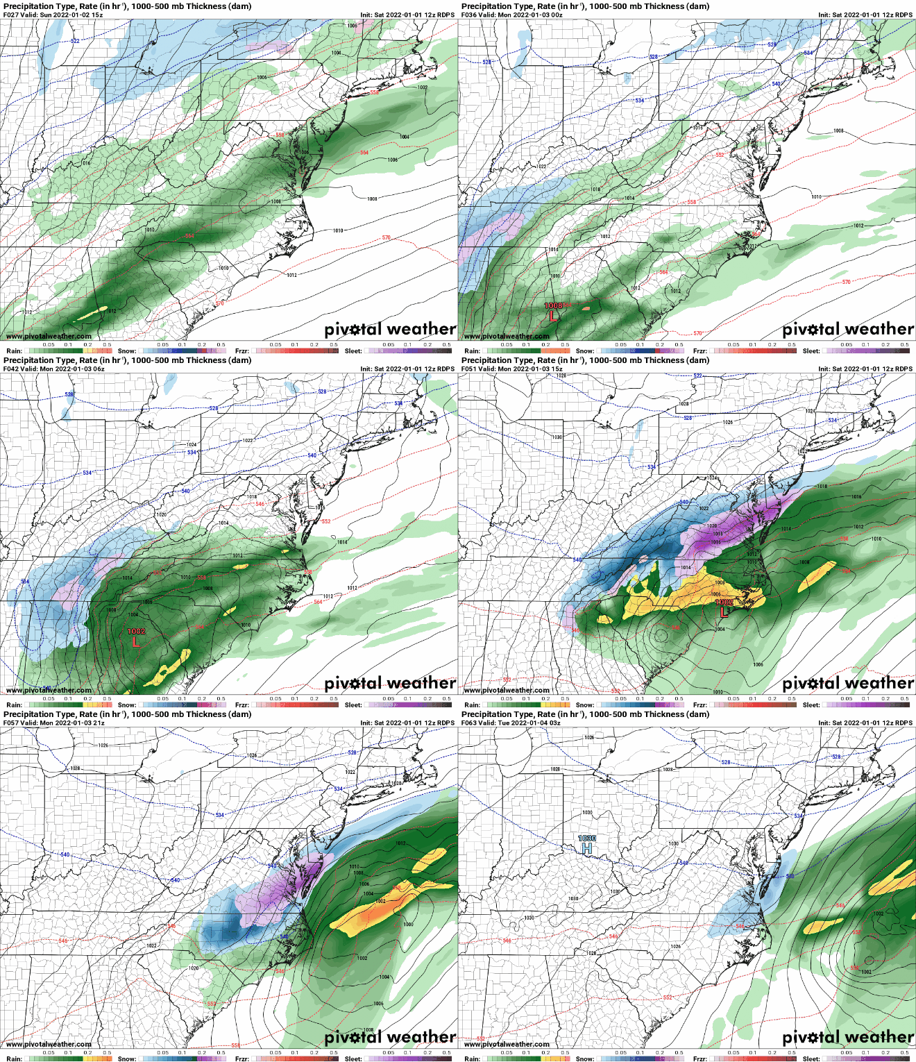
At this point in time meteorologist begin to switch their focus from models like the GFS and European model to short range models like the NAM, HRRR, & RGEM. Only 36 away from this event, we should be getting some consensus at least among models like the GFS and Euro, but that is not happening. That is do to the extreme dynamics that are going to come into play with this storm. With 4-5 things that will be key to produce this snowstorm across WNC, it will be difficult to nail down actual projected totals until I see what the storm looks like on radar tomorrow. Nonetheless lets look at the most recent short range models, as well as what the GFS and European models are showing.

12z NAM

12z NAM Courtesy of Pivotalweather.com

The trusted local accounting firm for WNC, let the team of Adrianne & Caroyl take care of all of your tax needs. Whether you need payroll/business accounting help or assistance filing your personal taxes, these ladies are the experts to put your trust with. Give them a call (828) 684-7374 or visit their website http://www.kruseaccounting.com to set up your appointment today!

12z NAM-3km

3km NAM Courtesy of Pivotalweather.com

12z HRRR

12z HRRR Courtesy of Pivotalweather.com

Ground Temps A Concern For Accumulation

Heavy rate of snowfall will overcome very warm ground temperatures in many situations. I believe that is why the models still show accumulation with this system, even though the ground has been so warm. If the snow can create a slushy layer on top of the ground, then it starts to insulate itself as accumulation occurs. As soon as the accumulation stops, melting takes over. With temperatures not expected to get out of the 30’s on Monday, melt will be occurring but temperatures won’t rebound a quickly as we would like. Roadway issues could be a problem on Monday am, especially above 3000’. Depending on how strong the system gets, roadways could become an issue even in some valley locations. Still a lot of information to be detailed out. Below is one more short range model (RGEM) & then the most recent GFS & European model runs.

12z RDPS

RDPS Courtesy of Pivotalweather.com

12z GFS

GFS Courtesy of Pivotalweather.com

6z European

6z European Model Courtesy of Pivotalweather.com

Conclusion

More info is need and I will produce another snowfall map tomorrow before the storm. Look for that and look for another YouTube video tomorrow detailing out the radar trends.

First Accumulating Snowfall of Season Possible For All of WNC Sunday Night & Into Monday

Models Trending Toward Very Cold & Snowy Sunday

Flooding Rain Threat Has Diminished

We have had our eye on this for several days, and we are beginning to see a common trend of cold and blowing snow on Sunday afternoon and into Monday for all of WNC among global models. Temperatures on Sunday appear as though they will rocket to near 60 before the frontal passage occurs, then early Sunday afternoon as the front passes temperatures will plummet into the 20’s. Check out the depiction below of the GFS that shows how quickly the temperatures will change.

GFS Courtesy of Pivotalweather.com

The trusted local accounting firm for WNC, let the team of Adrianne & Caroyl take care of all of your tax needs. Whether you need payroll/business accounting help or assistance filing your personal taxes, these ladies are the experts to put your trust with. Give them a call (828) 684-7374 or visit their website http://www.kruseaccounting.com to set up your appointment today!

Who Will See Snowfall?

Right now it appears as though most everyone who lives above 2000’ will see some form of snowfall on Sunday as this strong system passes by. Accumulation around the Asheville area is still very much in question, but the GFS model has been indicating it will be possible for the past 8 runs now, so it should be taken seriously. Below you can see the most recent GFS (6z) and how it depicts the system to move through.

GFS Courtesy of Pivotalweather.com

Contact my local trusted roofing source Matt at RedWolf Contracting Services to take care of all of your roof replacements. From shingles, to metal roofing, and even commercial rubber membrane, Matt has the resources and solutions to take care of your job in a professional and cost effective manner. Call (828) 772-9778 or visit nc-roofers.com to set up your free roof inspection.

European Model

The European model has been struggling with this solution and has now at the 0z run came towards a similar solution to what the GFS was showing. With the strong low cutting across the state of NC, this backside will have some power. It will also have access to the Great Lakes which haven’t frozen yet, so expect that to enhance the Northwest Flow. Below you can see how the Euro compares to the GFS.

Euro Courtesy of Pivotalweather.com

Flash Flooding Threat Reduced

The threat for flash flooding appears to have subsided with only beneficial rainfall expected to fall now. 1”+ or so of rainfall will be likely around most areas of WNC with higher totals found on the Blue Ridge Escarpment. Totals of 4”-6” will not be found as the dynamics of this storm will setup more conducive to snow compared to heavy rainfall. Below you can see the snowfall totals projected by the GFS.

GFS Snowfall Map Courtesy of Pivotalweather.com

Cold Week In Store For WNC Next Week

Below you can the European Ensemble and its projected temperatures for next week. It will certainly feel like winter!! The days of 60’s-70’s may be gone until March now so I hope you enjoyed them. We will continue to have frontal passages through the early part of January so the pattern will stay active. Be sure to subscribe to my YouTube page to get all the latest updates!