
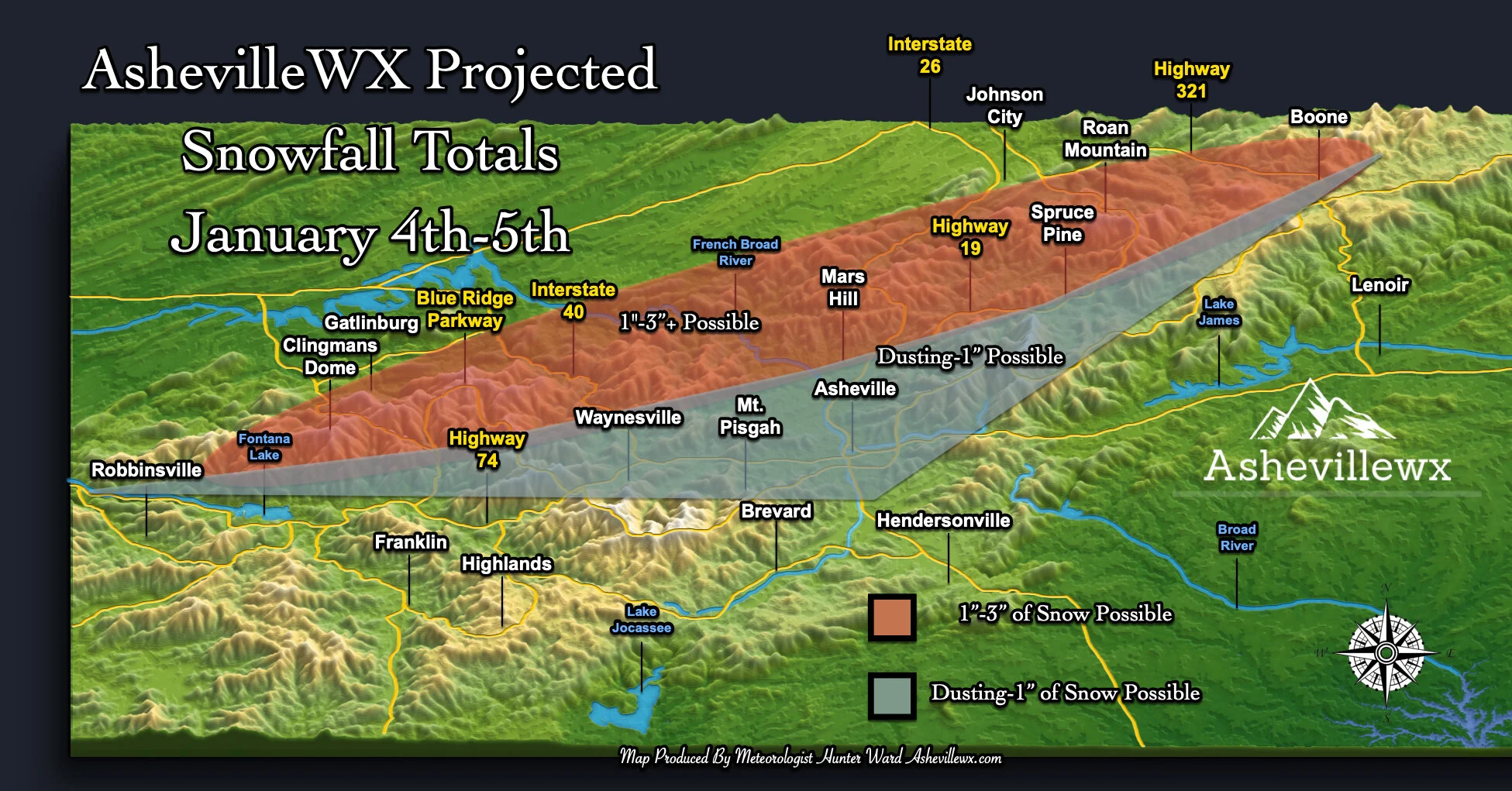
Below is my projected snowfall map for WNC as an Upper Level Low brings snow to many Saturday evening and into Sunday. This will be similar to the other minor snowfall events that we have experience already this winter, and low impacts should be expected. Roadways above 3000’ could become slick as night falls on the area tomorrow evening and frozen precipitation begins to fall. Locations below 3000’ could experience some mixing issues for an hour or so as the cold air aloft works its way down. Surface temperatures are not conducive for accumulation below 3000’, especially on the roadways. Isolated accumulation will be possible below 3000’, but as you get closer to Asheville the chances will decrease.

Contact my local trusted roofing source Matt at RedWolf Contracting Services to take care of all of your roof replacements. From shingles, to metal roofing, and even commercial rubber membrane, Matt has the resources and solutions to take care of your job in a professional and cost effective manner. Call (828) 772-9778 or visit nc-roofers.com to set up your free roof inspection.
The trusted local accounting firm for WNC, let the team of Adrianne, Caroyl, & Naomi take care of all of your tax needs. Whether you need payroll/business accounting help or assistance filing your personal taxes, these ladies are the experts to put your trust with. Give them a call (828) 684-7374 or visit their website http://www.kruseaccounting.com to set up your appointment today!
What Do Models Show This Morning?
We have transitioned somewhat to short range models now, and although I still look at long range models… I use the short range models to nail down my projected totals. Below you can the most recent precipitation depiction for the entire run of the Nam 3km. Another round of rainfall will move in over the next 2-3 hours, and then scattered showers could follow. Then all eyes will turn to the Upper Level Low and the backside moisture that it will bring Saturday afternoon.
3km Nam Precipitaion GIF Courtesy of Weathermodels.com

Come to where Mother Nature waved her magic wand and created one of the most natural of all wonders, Natural Hot Mineral Waters. Heated deep within the earth, these crystal clear carbonated waters are are world famous for their mineral content and legendary healing powers. We pipe these waters to modern outdoor jetted hot tubs that we rent privately by the hour. In addition to our World Famous Natural Hot Mineral baths the day spa offers massage, body treatments, and skin care options. Hot Springs Resort also offers accommodations and camping options. Please visit http://www.nchotsprings.com for more information.
Model Snowfall Maps
The 3km Nam is very bullish for the High Elevations and believes that some locations could receive over 5” of snowfall. Usually this model is a bit high with total though, so that’s why I am call for 1”-3”+ for locations above 3500’ within 15 miles of the NC/TN border. Below you can see the 3km Nam projected snowfall.
3km Nam projected snowfall totals courtesy of Weathermodels.com
The National Weather Service also puts out a projection for snowfall and below is that map. They believe that around an inch will be possible in the Boone area, and just a dusting around Asheville. My thoughts are in line with theirs.
NWS Map Provided By Weathermodels.com
High Wind Gusts Likely Sunday Morning
The Nam 3km is indicating that 40mph+ gusts will be possible around Downtown Asheville early Sunday morning, and gusts over 60mph will be possible above 3500’. It would be wise to secure outdoor accessories tonight. This will not be the weekend to take down Christmas lights! I gave you your warning last week! Below you can see the most recent Nam 3km regarding wind gust Sunday AM.
Call the team that keeps my truck clean at A&R Specialist! David, Matt & Harley run A&R Specialist at 621 Brevard Rd. and they are the guys to trust with your vehicle cleaning & detailing. Whether you need a deep wax every once in a while or a quality clean and detail, you can feel safe putting your car in the hands of A&R Specialist! Call (828) 708-3718 to set up your appointment today. https://www.facebook.com/ARpressurewashing4/
Nam 3km Wind Gusts For Sunday AM Courtesy of Weathermodels.com
Relatively Low Impact Event For Asheville
There may be some snow showers for the area, and a dusting of snowfall cannot be ruled out.. but this will be another low impact event for the Asheville area. Our high impact events typically move in from the South, and only a few times can I remember an Upper Level Low dropping more than an inch or two of snow around Asheville. I think that the wind chill and blowing snow will be the story on Sunday morning around Asheville, with limit if any ice on roadways. Check out the AshevilleWX Live Cameras to see where snow is falling!


