
After a near record high for Christmas Day around WNC, another front will bring rainfall to the area late this weekend and into early next week. The next threes days though (Thursday, Friday & Saturday) should be beautiful days with highs in the upper 50’s & low 60’s, so get out and enjoy them because a pattern change is coming. Below you can see the most recent Nam 3km temperature depiction for this afternoon (Thursday) and temps could push close to 60 degrees or even higher in some locations! The next two days will be choice days to take down Christmas lights!!
Courtesy of Weathermodels.com

Call the team that keeps my truck clean at A&R Specialist! David, Matt & Harley run A&R Specialist at 621 Brevard Rd. and they are the guys to trust with your vehicle cleaning & detailing. Whether you need a deep wax every once in a while or a quality clean and detail, you can feel safe putting your car in the hands of A&R Specialist! Call (828) 708-3718 to set up your appointment today. https://www.facebook.com/ARpressurewashing4/
With highs expected in the upper 50’s and low 60’s it will feel very unseasonable around WNC! This theme will continue through Saturday. Then a strong low pressure will get its act together moving across the Midwest. As the pressure drops over the Great Lakes, severe weather could be possible late Sunday evening. In fact I wouldn’t be surprised to hear a few rumbles of thunder around WNC late Sunday. That will soon be followed by several individuals proclaiming that snow will follow in the next 10 days.

Contact my local trusted roofing source Matt at RedWolf Contracting Services to take care of all of your roof replacements. From shingles, to metal roofing, and even commercial rubber membrane, Matt has the resources and solutions to take care of your job in a professional and cost effective manner. Call (828) 772-9778 or visit nc-roofers.com to set up your free roof inspection.
Heavy Rain Expected Sunday Night
As this low pressure deepens around the Great Lakes, the chances for severe weather around WNC will increase. Below you can see a depiction of what the most recent GFS shows timing wise when the system moves in. As you can see, this model shows the heaviest of rain moving in late Sunday evening and persisting through the early hours of Monday around WNC.
GFS Courtesy of TropicalTidbits.com
How Much Rainfall Is Expected?
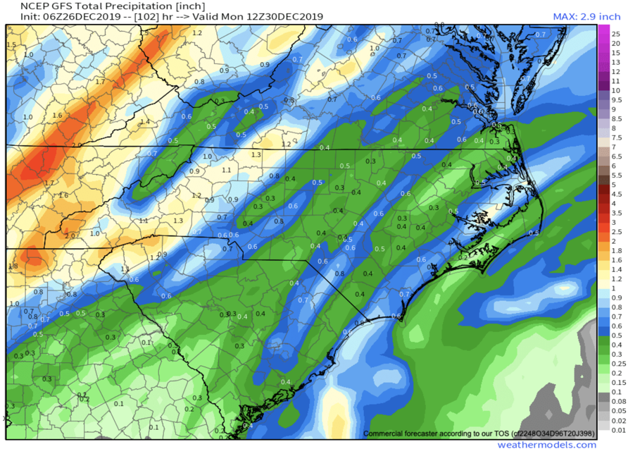
Around an inch for most areas looks possible through Monday morning, but isolated locations in SW WNC like Murphy could see higher totals. As this front approaches from the Southwest, excesses moisture will be strained out along those SW WNC locations in the tip of NC. Below you can compare both the Euro and GFS precipitation totals through Tuesday. Both indicate around 1” of precipitation is possible.
GFS Courtesy of Weathermodels.com
The trusted local accounting firm for WNC, let the team of Adrianne, Caroyl, & Naomi take care of all of your tax needs. Whether you need payroll/business accounting help or assistance filing your personal taxes, these ladies are the experts to put your trust with. Give them a call (828) 684-7374 or visit their website http://www.kruseaccounting.com to set up your appointment today!
ECMWF Courtesy of Weathermodels.com
From the images you can see that the GFS is somewhat more bullish on the amount of precipitation that will fall. The Euro orients the heaviest band of precipitation along the Blue Ridge Escarpment whereas the GFS orients the precipitation to move over the Murphy/Franklin area. Depending on where this strong banding sets up will determine who gets the most rainfall.

Come to where Mother Nature waved her magic wand and created one of the most natural of all wonders, Natural Hot Mineral Waters. Heated deep within the earth, these crystal clear carbonated waters are are world famous for their mineral content and legendary healing powers. We pipe these waters to modern outdoor jetted hot tubs that we rent privately by the hour. In addition to our World Famous Natural Hot Mineral baths the day spa offers massage, body treatments, and skin care options. Hot Springs Resort also offers accommodations and camping options. Please visit http://www.nchotsprings.com for more information.
High Winds/Snow Showers Likely Above 3500’ on Backside
After this front passes, winds will really pick up and gust over 30mph in many locations around WNC. As the low pressure continues to strengthen over the Great Lakes, Northwest Flow moisture will begin to move into the higher elevations of WNC. This appears to occur late Monday night and into Tuesday Morning. There are still several details that will need to be hammered down to determine how much snow is expected for the higher elevations. I will also have to dive a bit more into the details over the next few days to identify if snowflakes will indeed make it to Asheville with this flow. Check back near the end of the weekend for another update!


