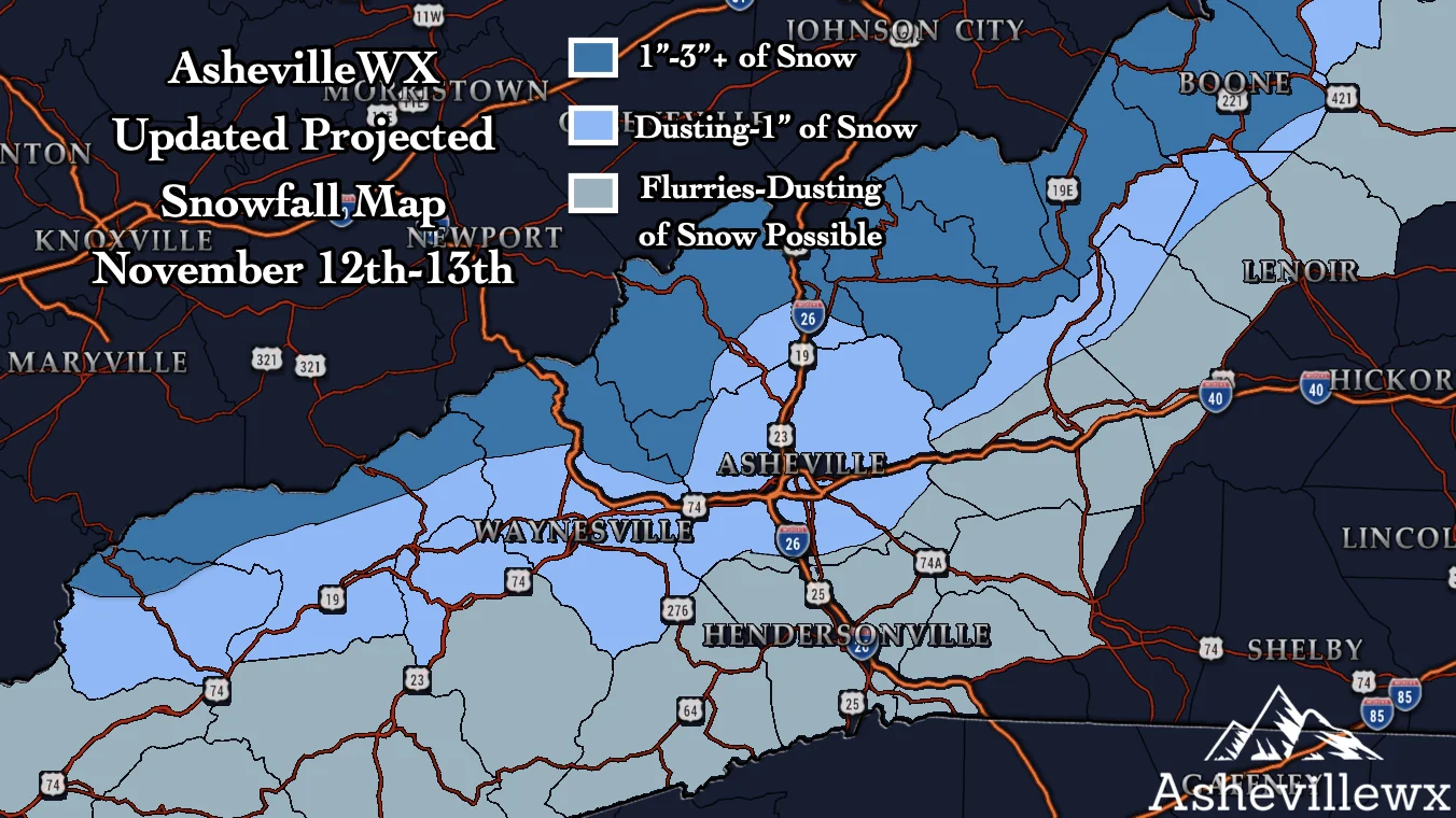
I am still watching a strong arctic front that is expected to move into WNC early Tuesday morning. As it pushes cold air out in front, some locations will switch from rain to snow early Tuesday morning. Locations above 3500’ stand a much chance of switching over on the frontside. After the front passes, the winds will pick up all across the area, and Northwest Flow snow showers will commence. This will begin around sunset or a couple of hours before in Asheville I believe, and that is when I believe the chance for accumulation will be possible. Below you can see my projected snowfall amounts for this event. These amount are subject to change, but it should give you a general idea of what I am expecting for the area.
Call the team that keeps my truck clean at A&R Specialist! David, Matt & Harley run A&R Specialist at 621 Brevard Rd. and they are the guys to trust with your vehicle cleaning & detailing. Whether you need a deep wax every once in a while or a quality clean and detail, you can feel safe putting your car in the hands of A&R Specialist! Call (828) 708-3718 to set up your appointment today. https://www.facebook.com/ARpressurewashing4/
Timing
Here is the Nam 3km and as you can see, rain will quickly switch to snow on Tuesday morning around portions of WNC. Then Northwest flow moisture pushes into the area following that. Winds will likely gust over 30mph Tuesday afternoon, and as moisture is strained along the NC/TN border, those winds will propel flakes into the valleys below.
Come to where Mother Nature waved her magic wand and created one of the most natural of all wonders, Natural Hot Mineral Waters. Heated deep within the earth, these crystal clear carbonated waters are are world famous for their mineral content and legendary healing powers. We pipe these waters to modern outdoor jetted hot tubs that we rent privately by the hour. In addition to our World Famous Natural Hot Mineral baths the day spa offers massage, body treatments, and skin care options. Hot Springs Resort also offers accommodations and camping options. Please visit http://www.nchotsprings.com for more information.
Nam3km Simulated Radar Courtesy of Weathermodels.com
Contact my local trusted roofing source Matt at RedWolf Contracting Services to take care of all of your roof replacements. From shingles, to metal roofing, and even commercial rubber membrane, Matt has the resources and solutions to take care of your job in a professional and cost effective manner. Call (828) 772-9778 or visit nc-roofers.com to set up your free roof inspection.
High Winds & Teens Likely
Winds will gust close to 40mph around Asheville on Tuesday evening, and that could cause several problems around the area including power outages. Schools could also be affected on Wednesday morning with frozen roads possible around the area due to most locations dropping into the upper teens! Join me live tonight at 8pm for a live update regarding what to expect for your area!


