
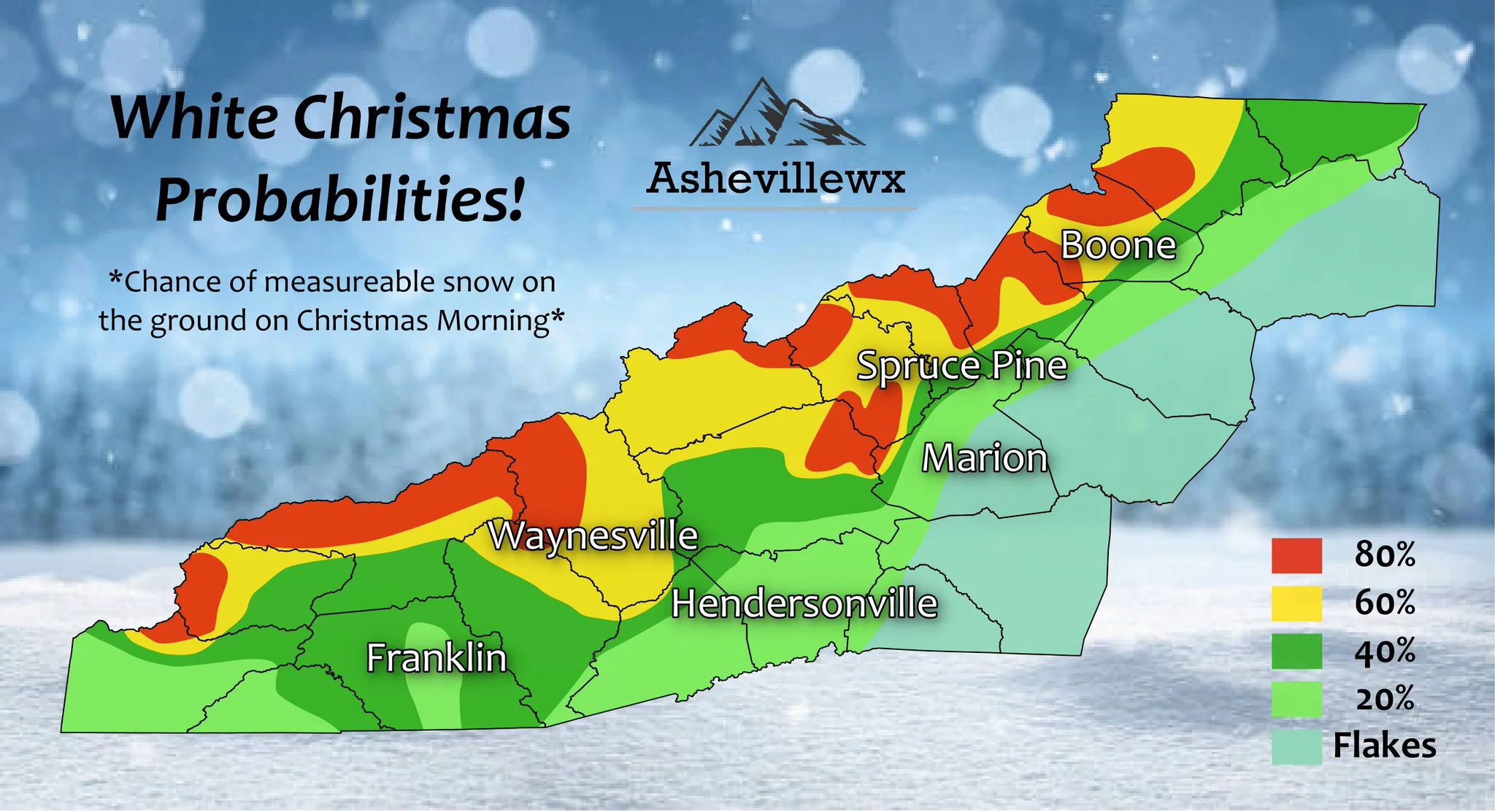
Model data continues to come in, but what has been consistent is the idea of very strong Upper Level Low moving over WNC later Christmas Eve night and into Early Christmas Morning. The timing of this low will be crucial for snow accumulation, and a late night/early Christmas morning arrival will be imperative for snow to accumulate in valley locations. Below you can see the map that Evan Fisher has put together for us regarding our thoughts currently on your chances for seeing a White Christmas. Which we are considering measurable snowfall on the ground on Christmas Morning.
Map Produced By Evan Fisher
We're here to help reduce the use of single-use plastics by offering bulk refills of household needs. Come refill your empty containers (shampoo bottles, hand soap dispensers, laundry detergent containers, jars etc) with our more natural products and pay by the ounce! To The Brim Click Here
Model Data
Timing is really what will be key with this system to get accumulating snowfall down into many valley locations where most of the population lives. If this backside Upper Level Low comes through right as the sun is setting Christmas Eve night, then the chance for accumulation increases. If it comes through around noon on Christmas Eve then we will just see some festive snow showers that accumulation on grassy surfaces. Watch the GFS below for the most recent depiction of what could unfold.
GFS Courtesy of Pivotalweather.com

Come to where Mother Nature waved her magic wand and created one of the most natural of all wonders, Natural Hot Mineral Waters. Heated deep within the earth, these crystal clear carbonated waters are are world famous for their mineral content and legendary healing powers. We pipe these waters to modern outdoor jetted hot tubs that we rent privately by the hour. In addition to our World Famous Natural Hot Mineral baths the day spa offers massage, body treatments, and skin care options. Hot Springs Resort also offers accommodations and camping options. Please visit http://www.nchotsprings.com for more information.
Short Range Model Data
Now let’s compare the GFS with what the NAM is showing. Keep in mind that this occurs at the very end of the NAM and it is just getting into range. Also not the severe threat for WNC on Thursday during the day. Don’t be surprised to see Thunderstorms sometime during the day on Christmas Eve.
12z NAM Courtesy of Pivotalweather.com
The trusted local accounting firm for WNC, let the team of Adrianne, Caroyl, & Naomi take care of all of your tax needs. Whether you need payroll/business accounting help or assistance filing your personal taxes, these ladies are the experts to put your trust with. Give them a call (828) 684-7374 or visit their website http://www.kruseaccounting.com to set up your appointment today!
Christmas Eve Thunderstorm Threat
Ahead of the snowfall chance, a wicked arctic front will move through. This strong gradient will create great lift and thunderstorms will develop out ahead of the frontal passage. Some locations could even see hail or a switch to snow/grapel as the arctic front pushes through during the day Thursday. These dynamic systems can produce interesting weather and heavy bursts of snow will be likely during the day above 4500’.
Sharp Temperature Drop & Flash Freeze Possible Christmas Eve
The coldest temperatures of the season so far are coming on Christmas. Watch for a flash freeze on Christmas Eve night and into Christmas Morning as wet roads are greeted with temps in the 20’s. The high will likely not rise above freezing on Christmas day, and snow flurries could be flying for many throughout the day. It will not be a good day to get outside and try out your new toys! Lows on Christmas night will drop into the low teens and even single digits in many areas. Locations above 4500’ could fall below zero! Watch below as the GFS depicts the incoming arctic front!
GFS Temperatures Courtesy of Pivotalweather.com

Call the team that keeps my truck clean at A&R Specialist! David, Matt & Harley run A&R Specialist at 621 Brevard Rd. and they are the guys to trust with your vehicle cleaning & detailing. Whether you need a deep wax every once in a while or a quality clean and detail, you can feel safe putting your car in the hands of A&R Specialist! Call (828) 708-3718 to set up your appointment today. https://www.facebook.com/ARpressurewashing4/
Cold Weekend Ahead
The long range European temperature spread is bitter cold for next weekend. Lows will drop into the teens each night and we will struggle to push out of the 40’s each day.
Euro Temperature Spread Courtesy of Weathermodels.com

Contact my local trusted roofing source Matt at RedWolf Contracting Services to take care of all of your roof replacements. From shingles, to metal roofing, and even commercial rubber membrane, Matt has the resources and solutions to take care of your job in a professional and cost effective manner. Call (828) 772-9778 or visit nc-roofers.com to set up your free roof inspection.
Long Range Models Favorable For Snowfall
I have my eye on this pattern change, and the long range indices are pointing towards a -NAO developing and a -AO also coming to fruition. That means cold air will be dumping into the central portion of the US and storms that come through will be turned up the East Coast rather than moving out to sea. A perfect recipe for a strong winter storm on the East Coast around the begining of the New Year. I am watching around the 30th-1st for a low pressure to come out of Mexico. This has a chance of running into some very favorable Canadian or even Arctic air. This occurs because it appears that the Polar Vortex will split, and that cold air that usually is bottled up north, will move down south. Right now I am just watching this, but I will have more information on possibilities as model runs become more consistent.


