
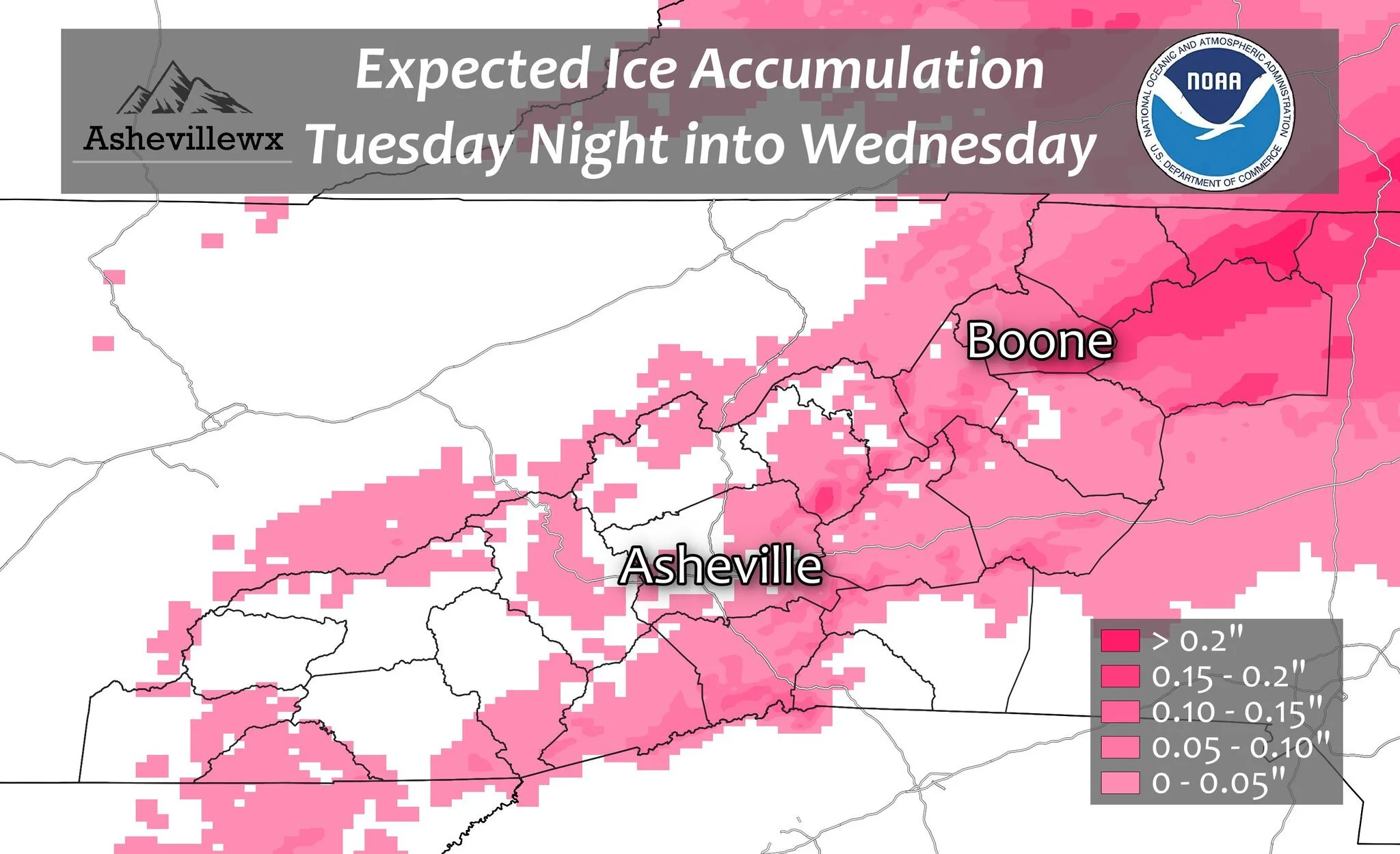
A Miller B type system will move into WNC late tonight where a cold wedge will have entrenched itself over WNC. This shallow layer of cold air that is funneled in by a strong high to our NW will create a difficult forecast for the area. Locations along The Blue Ridge Escarpment will have the highest chance to see accumulating ice, but the chance will be possible for slight ice accumulation even into the Asheville area. Below you can see a map produced by the National Weather Service regarding projected ice totals.
Map Data Created By NWS & Map Produced By Evan Fisher
The trusted local accounting firm for WNC, let the team of Adrianne, Caroyl, & Naomi take care of all of your tax needs. Whether you need payroll/business accounting help or assistance filing your personal taxes, these ladies are the experts to put your trust with. Give them a call (828) 684-7374 or visit their website http://www.kruseaccounting.com to set up your appointment today!
Model Details
Models continue to show light freezing rain moving into WNC very late tonight or early tomorrow morning. Though light, this could cause some slight problems on roadways in counties that border the NC/SC line. Below you can see the most recent NAM 3km precipitation depiction.
NAM 3km Courtesy of Weathermodels.com

Call the team that keeps my truck clean at A&R Specialist! David, Matt & Harley run A&R Specialist at 621 Brevard Rd. and they are the guys to trust with your vehicle cleaning & detailing. Whether you need a deep wax every once in a while or a quality clean and detail, you can feel safe putting your car in the hands of A&R Specialist! Call (828) 708-3718 to set up your appointment today. https://www.facebook.com/ARpressurewashing4/
Now you can compare that with the GFS model that also shows the light icing. Once again, I think that this will be a light event, but even light icing can cause isolated problems for some. Initially a few sleet pellets or even snowflakes could mix in as precipitation begins, but this will quickly switch to rain or freezing rain for most all. As you progress towards the Piedmont the chance for more significant icing will come into play. Locations like Hickory and Greensboro have a much better chance to see Ice accretion compared to Asheville.

GFS Courtesy of TropicalTidbits.com

Contact my local trusted roofing source Matt at RedWolf Contracting Services to take care of all of your roof replacements. From shingles, to metal roofing, and even commercial rubber membrane, Matt has the resources and solutions to take care of your job in a professional and cost effective manner. Call (828) 772-9778 or visit nc-roofers.com to set up your free roof inspection.
Northwest Flow Snow Possible On Backside
Several details still need to be resolved, but there is a chance on the backside of this storm that we see some snowflakes flying around the Asheville area. This would be Thursday morning if it were to occur. I expect locations above 3000’ along the NC/TN border to certainly see snowfall on this backside with at least a light accumulation. Above 4500’ 1”-2” will be possible and 3”+ will be likely in those highest elevations above 5000’. Below you can see the most recent projected snowfall map from the NAM 3km.
Nam3km Snowfall Map Courtesy of Weathermodels.com
We're here to help reduce the use of single-use plastics by offering bulk refills of household needs. Come refill your empty containers (shampoo bottles, hand soap dispensers, laundry detergent containers, jars etc) with our more natural products and pay by the ounce! To The Brim Click Here
Extended Forecast
A cold front will dominate the area through the end of the week, and then Saturday appears to be the choice day of the weekend! Following Saturday, rainfall could move in late on Sunday bringing around a half inch of rain or so to the area. Check out the most recent European model 10 Day projection below.
10 Day Euro Courtesy of Weathermodels.com

Come to where Mother Nature waved her magic wand and created one of the most natural of all wonders, Natural Hot Mineral Waters. Heated deep within the earth, these crystal clear carbonated waters are are world famous for their mineral content and legendary healing powers. We pipe these waters to modern outdoor jetted hot tubs that we rent privately by the hour. In addition to our World Famous Natural Hot Mineral baths the day spa offers massage, body treatments, and skin care options. Hot Springs Resort also offers accommodations and camping options. Please visit http://www.nchotsprings.com for more information.


