It has been hot around WNC! Currently September of 2019 ranks 3rd for the hottest September ever recorded in WNC! With the average temperature currently for the whole month at 73.3 degrees, it ranks just behind 1925 (73.6 degrees), and 2018 at (74.1 degrees). With temperatures expected to reach close to 85 again today and tomorrow, we could easily see 2019 move into second place behind 2018.
A Cool Down Is Coming!
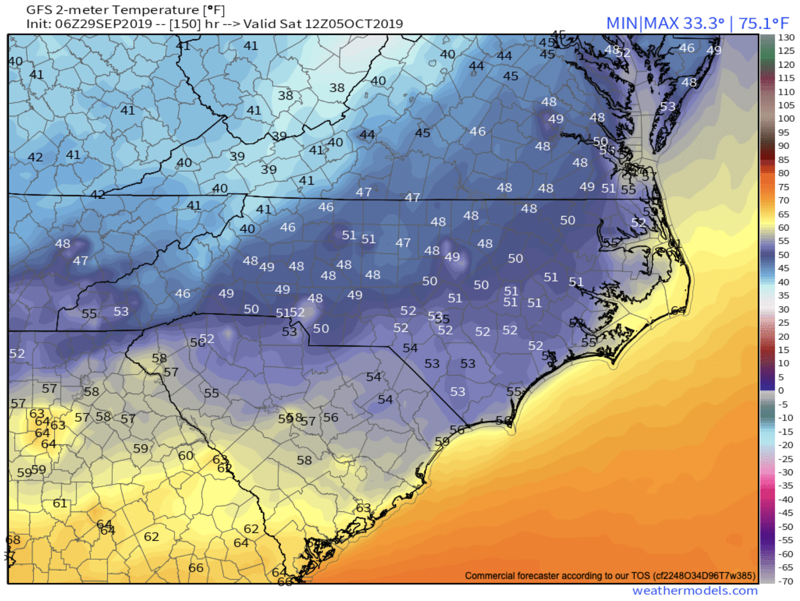
Finally the long range models are beginning to lock onto an extended period of average to below average temperatures. We should at least experience 3-4 days of 70 degree highs, and lows in the mid to upper 40’s next weekend. Below you can see the most recent GFS model run, and it indicates that mid 40’s will be possible early next Saturday morning. This will finally feel like fall, and it will be fitting since fall is already here lol.
Courtesy of Weathermodels.com
How Much Rainfall Will WNC Receive This Week?
This is a great question, and will vary from valley to valley around WNC. Yesterday I saw reports of some locations seeing over 2” of rainfall from the strong storm that developed in South Asheville. At my location in Alexander, NC I received .05” of rainfall. So, some locations got hammered with rain, while others barely receive any precipitation. Looking ahead, that theme appears to continue. Storms will be possible Sunday, Monday, & Tuesday around WNC, and then we will see another front late next week. Below you can see the most recent NAM 3km model run.
courtesy of Weathermodels.com
Contact my local trusted roofing source Matt at RedWolf Contracting Services to take care of all of your roof replacements. From shingles, to metal roofing, and even commercial rubber membrane, Matt has the resources and solutions to take care of your job in a professional and cost effective manner. Call (828) 772-9778 or visit nc-roofers.com to set up your free roof inspection.
Wetter Pattern In Store
Most long range models now show a somewhat wet pattern beginning late next week around WNC, and that is great news. Currently all locations around WNC are in a drought, and there are several burn bans in place including one for Buncombe County. Below you can see the most recent European Model run and it suggests that a good slug of moisture will likely move in late next weekend or early next week. We haven’t seen precipitation like this showing up on long range models for some time, so in my opinion this is a very good sign regarding breaking out of the drought.
Courtesy of Weathermodels.com
Drought Monitor
Below is the Southeast Drought Monitor produced every Thursday by the USDA. This week, many locations in WNC were added to this map. The progressing pattern though appears to bring in more moisture compared to what we have seen over the past month, so there is a decent chance that we could break out of this drought in the next two weeks. Stick with me here at AshevilleWX and I will keep you updated!
Call the team that keeps my truck clean at A&R Specialist! David, Matt & Harley run A&R Specialist at 621 Brevard Rd. and they are the guys to trust with your vehicle cleaning & detailing. Whether you need a deep wax every once in a while or a quality clean and detail, you can feel safe putting your car in the hands of A&R Specialist! Call (828) 708-3718 to set up your appointment today. https://www.facebook.com/ARpressurewashing4/


