
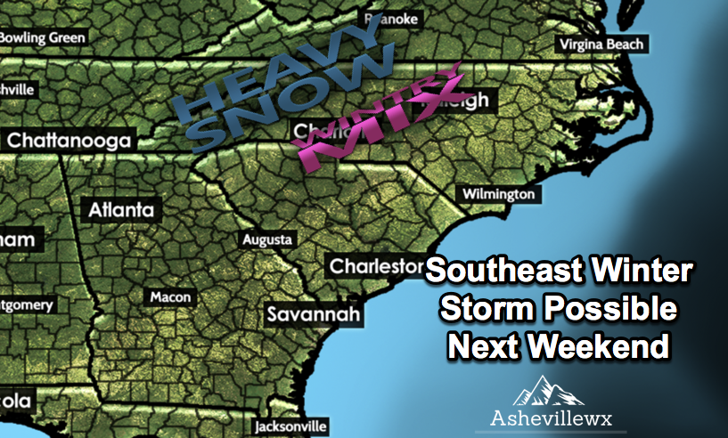
Interesting Week Of Weather On Tap For WNC
With snow flurries possible both Tuesday and Wednesday, then the potential for a gulf low to develop into the weekend.. the weather around WNC is about to get very interesting. Many of the major models suggest that a large winter storm could move through the southeast next weekend, causing a multitude of problems. This is not set in stone though, so some caution must be taken when review the following model data. These are simply model depictions and should not be taken as spoken word.
Snow Showers/Flurries Tuesday & Wednesday
Backside moisture will stream through the area Tuesday and into Wednesday bring the chance for snow showers in the higher elevations (above 3500’), and snow flurries in the lower elevations around Asheville. A couple of inches cannot be ruled out in the highest elevations, and a dusting cannot be ruled out north of Asheville.. but this appears to be less impactful compared to the system projected to move in late Friday night.

Need Tax Help?
Let C.P. Krause & Co. help guide you through the confusion of tax season with ease! Set up your appointment today by calling (828) 684-7374 or by visiting their website at http://www.kruseaccounting.com
Gulf Low Develops
On Friday, a system develops over Texas, and begins to move towards the Southeast. This is aided by a strong banana high pressure that moves in tandem with the low. The banana high funnels in the cold air that could potential keep WNC as snow throughout the duration of the event. As you can see below on the GFS precipitation depiction, overrunning moisture begins to stream in late Friday night or early Saturday morning, and falls in the form of snow in many locations.
6z Precipitation Depiction Saturday Morning Courtesy of Weathermodels.com
The European model has been persistent with a similar solution for the past several days. The European Ensemble has also been showing a signal for a large winter storm for the past 2.5 days. This can all change quickly, but a stout high pressure like what is being modeled, is what many expected to occur this winter and can lead to some very impactful storms around WNC. Below you can see the potential snowfall total map produced by the most recent GFS. This is just one model depiction, but other models including the European have been spitting out similar solutions.

GFS 24hr snowfall total For Dec8th-9th Only A Model Depiction! Courtesy of Weathermodels.com
Here you can contrast that with what the European Models shows on these free maps that can be found at weather.us.
0z European Snow Depth Map Courtesy of Weather.us
Main Takeaway
Your main takeaway from this article is that there is the potential for a very impactful winter storm to affect WNC next weekend. Nothing is certain at this moment, but models have a frozen column in place when a strong system moves in, and they are spitting at large snowfall totals. I am watching every model update, so check back soon for another update!
