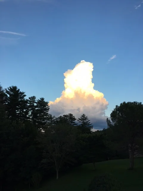
A rare and incredible sunset lit up the sky around WNC last night (September 3rd), and small supercells that had pop-up around sunset were set ablaze.
Time-lapse from Hendersonville, NC provided to Ashevillewx by Paul Jackson
These updrafts were in a relatively dry atmosphere aloft, so the cloud debris didn’t spread out. As the sun sets, the rays refracting around the earths surface fade and since red wave lengths are longer they linger the longest. These cloud are 30000ft in the air, so they see sunlight for long compared to the earths surface! You can even see some hints of mammatus clouds showing up in the photo from Black Mountain. Also, an interesting phenomenon known as anti-crepuscular rays can be seen from a few photos, especially from the one below near the Asheville Airport. I have never seen a cloud top produce anti-crepusuclar rays and have only seen photos of mountains producing them. It is a rare occurrence for sure.
Photo taken from near the Asheville Airport and provided by Sara Bender Hope
Photo taken from Brevard, NC and provided by ColinKirkman
You can see how the top of the cloud almost looks on fire, and the rays of light are absorbed and bend around the structure. At the base of the cloud you can see the red of the light spectrum. Those last lingering rays that bend around earths surface as the sun retreats. These rays hit the base of the cloud with a hue of red, because they have traveled farther than any other. One can see that since the top of cloud is higher, the sun can still hit it because if the angle in which the light is traveling. In a sense this represents the light spectrum, and could be used to prove that the earth is round. I as a meteorologist get caught up on the anti-crepuscular rays coming from behind the could, but there is just so much to marvel at in these various photos.
Photo taken in Etowah, NC provided by Jennifer Young
Photo taken from Mills River, NC proved by Michelle Johnston
Photo taken from Black Mountain, NC provided by Roxie Nation
Photo from Candler, NC taken by Stephaine Harris
Photo from Canton, NC taken by Carol Larsen
Usually these cells will spread out and winds aloft will blow cloud debris in a way that obscures your view from seeing the entire updraft. Luckily last night, unique conditions were set up, and it appeared to many that these cells we on fire! Thanks for sharing!
Photo taken from Travelers Rest, SC and provided by Stella Galyean
Photo taken from Fairview, NC by Mary Deckard
Photo sequence taken from Flat Rock, NC and provided by Didi Salvatierra


