

Rainfall Expected Tuesday For WNC
It has been quite some time since we have seen any sort of significant rainfall across WNC and many locations have moved into severe drought territory. Relief appears to be on the way for most on Tuesday though as a strong front moves through. High elevation locations could even see some icing from this event as temperatures will be marginal when precip arrives. Here is everything you need to know below about the front, how much rain will fall, and who could see winter weather.

How Much Rainfall Is Possible?
Upwards of 2” of rainfall could be possible for many locations around WNC as this low pressure moves through beginning early Tuesday morning. Below you can see a depiction of the GFS model and how much precipitation is projected to fall. The European model does not show as much precipitation, but still shows a good swath of rainfall. This will dampen the threat for fires and help firefighters get control of those blazes that are ongoing.
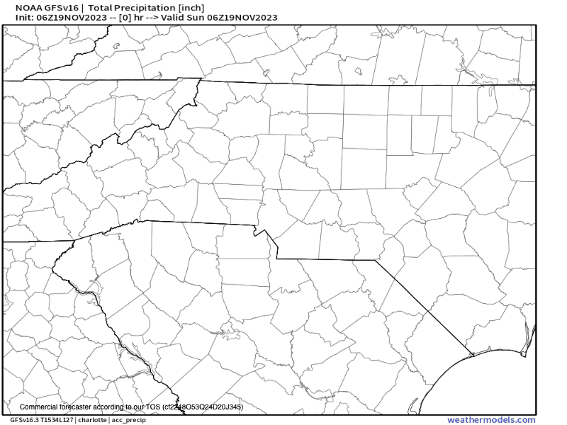
GFS Precipitation Totals Courtesy of Weathermodels.com

NAM Simulated Radar Courtesy of Weathermodels.com
When Will Rainfall Begin
Most models show scattered showers showing up very late Monday night or early Tuesday morning. That is followed by heavier rainfall that could have some embedded thunder. So rain will be lighter Tuesday AM, with heavier showers moving in as we progress towards darkness. There are some significant concerns with this system that I will go over below.
Dangerous System In Store
This storm is very much a blessing since we have been so dry around WNC. It will certainly put a damper on the wildfire concerns though it will not pull us out of a drought. There are some significant concerns to go over though with how dry things have been.
Heavy rainfall on very dry ground will immediately turn into runoff and could raise flash flooding concern.
Heavy rainfall on burn scar areas could cause mudslide conditions, especially around I-40 in the gorge near the Black Bear Fire.
Icing could occur above 5000’ closing parkway access to high elevations.
Winds on Monday Evening will raise fire concerns even more with gusts over 30mph in locations where fires are already occurring.
Wetter Pattern In Store
Most models have a Southern Jet that develops over the next 7 days that brings in a stream of much needed moisture into the South. This could really begin to crack the drought. There are also signs of cold being present near the end of the month and with a wetter pattern, that should raise snow lovers interest. Thanksgiving Day appears to be clear though so enjoy the Holiday and check back soon for more info!


